
Sülm
| coat of arms | Germany map | |
|---|---|---|

|
Coordinates: 49 ° 55 ' N , 6 ° 34' E |
|
| Basic data | ||
| State : | Rhineland-Palatinate | |
| County : | Eifel district Bitburg-Prüm | |
| Association municipality : | Bitburger Land | |
| Height : | 340 m above sea level NHN | |
| Area : | 7.05 km 2 | |
| Residents: | 409 (Dec. 31, 2019) | |
| Population density : | 58 inhabitants per km 2 | |
| Postal code : | 54636 | |
| Area code : | 06562 | |
| License plate : | BIT, PRÜ | |
| Community key : | 07 2 32 125 | |
| Association administration address: | Hubert-Prim-Strasse 7 54634 Bitburg |
|
| Website : | ||
| Mayoress : | Klara Weber | |
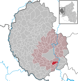
| Location of the local community Sülm in the Eifel district Bitburg-Prüm | ||
  |
||


Sülm is a municipality in the Eifelkreis Bitburg-Prüm in Rhineland-Palatinate . It belongs to the Verbandsgemeinde Bitburger Land .
geography
Sülm is located in the southwest Eifel , about five kilometers southeast of the district town of Bitburg . The municipal area extends over the so-called Bitburg plateau and covers an area of 705 hectares. 61.3% of this is used for agriculture, with 23.8% a comparatively low proportion of forest (as of 2017).
The Bernhardshof and Looskyllermühle residential areas also belong to Sülm .
history
In 634 Sülm and the places Welschbillig , Newel and Röhl with their churches and affiliations were given to the Church of St. Paulinus ( Paulinstift Trier ) by King Dagobert I (reign: 622–638, Trier stay: 624 to 625) . At that time Modoald was Bishop of Trier. In 981 this donation is mentioned in a document from Archbishop Egbert von Trier (Bishop from 977 to 993). Sülm is mentioned in the document mentioned for the first time under the name "Sulmana" and, as part of the Electorate of Trier, was subordinate to the Archbishop of Trier.
- Statistics on population development
The development of the population of Sülm, the values from 1871 to 1987 are based on censuses:
|
|
Municipal council
The municipal council in Sülm consists of eight council members, who were elected by a majority vote in the local elections on May 26, 2019 , and the honorary local mayor as chairman.
Attractions
Numerous renovated old farmhouses are spread across the municipality. The old war memorial chapel with a sandstone altar dates from 1631. Also worth seeing are grave crosses from the 16th and 17th centuries at the Sülmer cemetery smauer. In contrast to most burial sites in the Eifel district, several gravestones from the late 19th century have been preserved in the Sülmer cemetery . The construction of the parish church St. Petrus began in 1826, it had a late Gothic predecessor.
See also: List of cultural monuments in Sülm
Economy and Infrastructure
Today Sülm is an agricultural and touristic community. The place is the location of several full-time and part-time businesses as well as three schnapps distilleries . In the service area, it has a village inn, two private guest houses, a kindergarten and a public library .
The federal highway 51 , which leads to Bitburg and the federal highway 60 about ten kilometers away, runs about two kilometers west of the village .
Sports
Sülm forms the DJK Eintracht DIST sports club with the neighboring communities of Dahlem , Idenheim and Trimport .
Sons and daughters of the place
- Bernhard Lemling (1904–1961), well-known Eifel poet
Web links
- Website of the local community Sülm - www.suelm.de
- Local community Sülm on the website of the Verbandsgemeinde Bitburger Land
- To search for cultural assets of the local community Sülm in the database of cultural assets in the Trier region .
Individual evidence
- ↑ State Statistical Office of Rhineland-Palatinate - population status 2019, districts, communities, association communities ( help on this ).
- ↑ a b State Statistical Office Rhineland-Palatinate: Regional data.
- ↑ State Statistical Office Rhineland-Palatinate (ed.): Official directory of the municipalities and parts of the municipality. Status: January 2019 [ Version 2020 is available. ] . S. 109 (PDF; 3 MB).
- ↑ pfarierendengemeinschaft-speicher.de: Parish Sülm. History of the parish. Retrieved January 23, 2020.
- ^ The Regional Returning Officer Rhineland-Palatinate: Local elections 2019, city and municipal council elections
- ↑ Homepage of the DJK Eintracht DIST
Bath | Balesfeld | Baustert | Bettingen | Bickendorf | Biersdorf am See | Birtlingen | Brecht | Brimingen | Burbach | Dahlem | Dockendorf | Dudeldorf | Echtershausen | Ehlenz | Enzen | Esslingen | Etteldorf | Feilsdorf | Flowem | Gindorf | Gondorf | Gransdorf | Halsdorf | Hamm | Heilenbach | Hütterscheid | Hüttingen an der Kyll | Idenheim | Idesheim | Ingendorf | Kyllburg | Kyllburgweiler | Ließem | Malberg | Malberg soft | Meckel | Messerich | Metterich | Mülbach | Nattenheim | Neidenbach | Neuheilenbach | Niederstedem | Niederweiler | Oberkail | Oberstedem | Oberweiler | Oberweis | Olsdorf | Orsfeld | Pickleneem | Rittersdorf | Röhl | Saint Thomas | Sharply cheap | Schleid | Seffern | Seffer soft | Field of being | Steinborn | Stockem | Sülm | Trimport | Usch | Wettlingen | Wiersdorf | Wilsecker | Wissmannsdorf | Wolsfeld | Zendscheid