
Azé (Saône-et-Loire)
| Azé | ||
|---|---|---|
.svg)
|
|
|
| region | Bourgogne-Franche-Comté | |
| Department | Saône-et-Loire | |
| Arrondissement | Mâcon | |
| Canton | Hurigny | |
| Community association | Mâconnais Beaujolais Agglomération | |
| Coordinates | 46 ° 26 ' N , 4 ° 46' E | |
| height | 220-550 m | |
| surface | 14.97 km 2 | |
| Residents | 1,046 (January 1, 2017) | |
| Population density | 70 inhabitants / km 2 | |
| Post Code | 71260 | |
| INSEE code | 71016 | |
| Website | http://www.aze.fr/ | |

Azé is a French commune with 1,046 inhabitants (as of January 1 2017) in the department of Saone-et-Loire in the region of Bourgogne Franche-Comté . It belongs to the arrondissement of Mâcon and the canton of Hurigny (until 2015: canton of Lugny ). The inhabitants are called Azéens .
geography
Azé is located about 15 kilometers north-northwest of the city center of Mâcon in the Mâconnais in the Bourgogne wine-growing region . Azé is surrounded by the neighboring communities of Blanot in the north and north-west, Saint-Gengoux-de-Scissé in the north, Péronne in the east, Saint-Maurice-de-Satonnay in the east and south-east, Igé in the south, Cluny in the west and Donzy-le- Pertuis in the northwest.
Population development
| year | 1962 | 1968 | 1975 | 1982 | 1990 | 1999 | 2006 | 2013 |
|---|---|---|---|---|---|---|---|---|
| Residents | 570 | 548 | 553 | 649 | 807 | 940 | 992 | 1,030 |
| Source: Cassini and INSEE | ||||||||
Attractions
- prehistoric caves
- church
- Castle Aine with the arboretum
- Vaux-sur-Aine castle
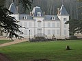
Aine Castle

Vaux-sur-Aine castle
_-_1.JPG)

Personalities
- Claude Guichard (born December 26, 1861 in Azé, † May 6, 1924 in Paris), mathematician and university professor
Web links
Commons : Azé - collection of images, videos and audio files