
Buhl (Haut-Rhin)
| Buhl | ||
|---|---|---|
.svg)
|
|
|
| region | Grand Est | |
| Department | Haut-Rhin | |
| Arrondissement | Thann-Guebwiller | |
| Canton | Guebwiller | |
| Community association | Region of Guebwiller | |
| Coordinates | 47 ° 56 ' N , 7 ° 11' E | |
| height | 313-842 m | |
| surface | 8.80 km 2 | |
| Residents | 3,310 (January 1, 2017) | |
| Population density | 376 inhabitants / km 2 | |
| Post Code | 68530 | |
| INSEE code | 68058 | |
| Website | http://www.ville-buhl.fr/ | |
,_Mairie.jpg) Mairie Buhl |
||

Buhl (German Bühl ) is a French commune with 3310 inhabitants (as of January 1, 2017) in the Haut-Rhin department in the Grand Est region (until 2015 Alsace ). She is a member of the Association of Municipalities Région de Guebwiller .
geography
Buhl is located on the river Lauch in the Ballons des Vosges Regional Nature Park . The D430 serves as the departmental road. It crosses a valley known as Florival , which extends south-east to Guebwiller . Buhl's neighboring villages are Murbach in the southwest (in between is the district of Rimlishof ), the Hugstein settlement with castle ruins in the southeast and Schweighouse (district of Lautenbach ) in the north. On both sides, the area is heavily forested, the east by a spur of the Forêt de Orschwihr communal (community forest of Orschwihr ).
Buhl station was on the Bollwiller – Lautenbach railway line .
history
Buhl was first mentioned in writing under the name Bühele in 1135. Later spellings were Buohele , Buohile , Bühel , and since the 16th century Bühl .
In 1227 Hugo (Hugues) de Rothenbourg, abbot of the Murbach monastery , had a castle built to protect the entrance to the Murbach valley.
From 1871 until the end of the First World War , Buhl belonged to the German Empire as part of the realm of Alsace-Lorraine and was assigned to the Gebweiler district in the Upper Alsace district .
| year | 1826 | 1861 | 1905 | 1936 | 1962 | 1968 | 1975 | 1982 | 1990 | 1999 | 2006 | 2017 | ||||||||||||||||||||||||||||||||||||||||||||||||||||||||||||||||||||||||||||||||||||||||||||||||||||||||||||||||||||||||||||||||||||||||||||||||||||||||||||||||||||||||||||||||||||||||||||||||||||||||||||||||||||||||||||||||||||||||||||||||||||||||||||||||||||||||||||||||||||||||||||||||||||||||||||||||||||||||||||||||||||||||||||||||||||||||||||||||||||||||||||||||||||||||||||||||||||||||||||||||||||||||||||||||||||||||||||||||||||||||||||||||||||||||||||||||||||||||||||||||||||||||
|---|---|---|---|---|---|---|---|---|---|---|---|---|---|---|---|---|---|---|---|---|---|---|---|---|---|---|---|---|---|---|---|---|---|---|---|---|---|---|---|---|---|---|---|---|---|---|---|---|---|---|---|---|---|---|---|---|---|---|---|---|---|---|---|---|---|---|---|---|---|---|---|---|---|---|---|---|---|---|---|---|---|---|---|---|---|---|---|---|---|---|---|---|---|---|---|---|---|---|---|---|---|---|---|---|---|---|---|---|---|---|---|---|---|---|---|---|---|---|---|---|---|---|---|---|---|---|---|---|---|---|---|---|---|---|---|---|---|---|---|---|---|---|---|---|---|---|---|---|---|---|---|---|---|---|---|---|---|---|---|---|---|---|---|---|---|---|---|---|---|---|---|---|---|---|---|---|---|---|---|---|---|---|---|---|---|---|---|---|---|---|---|---|---|---|---|---|---|---|---|---|---|---|---|---|---|---|---|---|---|---|---|---|---|---|---|---|---|---|---|---|---|---|---|---|---|---|---|---|---|---|---|---|---|---|---|---|---|---|---|---|---|---|---|---|---|---|---|---|---|---|---|---|---|---|---|---|---|---|---|---|---|---|---|---|---|---|---|---|---|---|---|---|---|---|---|---|---|---|---|---|---|---|---|---|---|---|---|---|---|---|---|---|---|---|---|---|---|---|---|---|---|---|---|---|---|---|---|---|---|---|---|---|---|---|---|---|---|---|---|---|---|---|---|---|---|---|---|---|---|---|---|---|---|---|---|---|---|---|---|---|---|---|---|---|---|---|---|---|---|---|---|---|---|---|---|---|---|---|---|---|---|---|---|---|---|---|---|---|---|---|---|---|---|---|---|---|---|---|---|---|---|---|---|---|---|---|---|---|---|---|---|---|---|---|---|---|---|---|---|---|---|---|---|---|---|---|---|---|---|---|---|---|---|---|---|---|---|---|---|---|---|---|---|---|---|---|---|---|---|---|---|---|---|---|---|---|---|---|---|---|---|---|---|---|---|---|---|---|---|---|---|---|---|---|---|---|---|---|---|---|---|---|---|---|---|---|---|---|---|---|---|---|---|---|---|---|---|---|---|---|---|---|---|---|---|---|---|---|---|---|---|---|---|---|---|---|---|---|---|---|
| Residents | 975 | 2,090 | 3,352 | 2,635 | 2,931 | 2,945 | 3,048 | 2,674 | 2,755 | 3,079 | 3,190 | 3,310 | ||||||||||||||||||||||||||||||||||||||||||||||||||||||||||||||||||||||||||||||||||||||||||||||||||||||||||||||||||||||||||||||||||||||||||||||||||||||||||||||||||||||||||||||||||||||||||||||||||||||||||||||||||||||||||||||||||||||||||||||||||||||||||||||||||||||||||||||||||||||||||||||||||||||||||||||||||||||||||||||||||||||||||||||||||||||||||||||||||||||||||||||||||||||||||||||||||||||||||||||||||||||||||||||||||||||||||||||||||||||||||||||||||||||||||||||||||||||||||||||||||||||||
| From 1962 official figures excluding residents with a second residence | ||||||||||||||||||||||||||||||||||||||||||||||||||||||||||||||||||||||||||||||||||||||||||||||||||||||||||||||||||||||||||||||||||||||||||||||||||||||||||||||||||||||||||||||||||||||||||||||||||||||||||||||||||||||||||||||||||||||||||||||||||||||||||||||||||||||||||||||||||||||||||||||||||||||||||||||||||||||||||||||||||||||||||||||||||||||||||||||||||||||||||||||||||||||||||||||||||||||||||||||||||||||||||||||||||||||||||||||||||||||||||||||||||||||||||||||||||||||||||||||||||||||||||||||||||||
coat of arms
Description : A silver triangle in red .
Attractions
In the neo-Romanesque church of Saint-Jean-Baptiste ( John the Baptist ) from the 19th century , you can see the Bühler winged altar , an altarpiece from the second half of the 1490s, which was created by successors and imitators of Martin Schongauer . It was brought to Buhl from a Colmar monastery during the French Revolution to protect it from destruction.
The ruins of Hugstein Castle from the 13th century are at the entrance to the Murbach Valley . Their remains are not only on the municipality of Buhl, but also on that of Guebwiller , because the border between the two municipalities runs right through the middle of the keep .
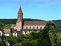
Johanneskirche in Buhl

Altar retable in the Johanneskirche

Remains of the gate tower of Hugstein Castle


Personalities
- Maurice Koechlin (1856–1946), a French engineer who played a key role in the construction of the Eiffel Tower , was born in Buhl.
literature
- Le Patrimoine des Communes du Haut-Rhin. Flohic Editions, Volume 1, Paris 1998, ISBN 2-84234-036-1 , pp. 471-475.
Web links
Individual evidence
- ↑ Municipal directory Germany 1900 - Gebweiler district
- ^ Jean-Marie Nick: Le Hugstein on chateauxforts-alsace.org, accessed November 17, 2011.