
Cristești (Mureș)
|
Cristești Maroskeresztúr |
|||||
|
|||||
| Basic data | |||||
|---|---|---|---|---|---|
| State : |
|
||||
| Historical region : | Transylvania | ||||
| Circle : | Mureș | ||||
| Coordinates : | 46 ° 30 ′ N , 24 ° 30 ′ E | ||||
| Time zone : | EET ( UTC +2) | ||||
| Height : | 302 m | ||||
| Area : | 13.35 km² | ||||
| Residents : | 5,824 (October 20, 2011) | ||||
| Population density : | 436 inhabitants per km² | ||||
| Postal code : | 547185 | ||||
| Telephone code : | (+40) 02 65 | ||||
| License plate : | MS | ||||
| Structure and administration (as of 2016) | |||||
| Community type : | local community | ||||
| Structure : | Cristeşti, Vălureni | ||||
| Mayor : | Edit Kovács (independent) | ||||
| Postal address : | Str. Principală, no. 678 loc. Cristeşti, jud. Mureș, RO-547185 |
||||
| Website : | |||||


Cristeşti [ kristeʃtʲ ] (deprecated Muras-Cristur ; Hungarian Maroskeresztúr ) is a commune in Mureş County , in the region of Transylvania in Romania .
Geographical location

The municipality of Cristești is located in the Transylvanian Basin (Podișul Transilvaniei) , north of the Kokel Valley (Podișul Târnavelor) , on the upper reaches of the Mureș (Mieresch) . On the national road DN15 - here part of the European route 60 - and the railway line Alba Iulia – Târgu Mureş (stop Târgu Mureş Sud ), the place Cristeşti borders on the south of the district capital Târgu Mureş (Neumarkt am Mieresch) .
The incorporated village of Vălureni (Hungarian Székelykakasd ) is about five kilometers from the community center.
history
The place Cristeşti was first mentioned in 1332.
On the area of the place, known by the locals as Hosuba - Asomureș , archaeological finds point to settlement as far back as Roman times - probably a Roman fort . At Cariera de nisip (sand pit), on the national road to Târgu Mureș, a Scythian necropolis from the Latène period is noted.
In the Middle Ages Cristeşti was a place inhabited by Szekler , in which the Hungarian noble family Vas settled after 1660 Romanian serfs.
In the Kingdom of Hungary , today's municipality belonged to the Maros alsó (Unter-Maros) district in Maros-Torda County , then to the historical Mureș District and, from 1950, today's Mureș District.
population
The population of the Cristești municipality developed as follows:
| census | Ethnic composition | ||||
|---|---|---|---|---|---|
| year | population | Romanians | Hungary | German | other |
| 1850 | 764 | 283 | 455 | 2 | 24 |
| 1930 | 1,739 | 461 | 1,164 | 2 | 112 |
| 1966 | 4.164 | 1,459 | 2,681 | 5 | 19th |
| 1992 | 5,622 | 2,250 | 2,833 | 1 | 538 |
| 2011 | 5,824 | 2,465 | 2,512 | - | 847 |
The highest number of inhabitants has been registered in the area of today's municipality since 1850 and that of Romanians and Roma (599) in 2011. The highest population of the Magyars was determined in 1992 and that of the Romanian Germans in 1966.
Attractions
- In the community center the old reformed church , built at the end of the 18th century.
- The reformed church in the incorporated village of Vălureni, built around 1860.

town hall

In the background the old reformed church in Cristeşti
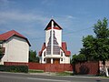
New Reformed Church in Cristeşti

Reformed Church in Vălureni


personality
- József Tövissi (1927–2015), born in Vălureni, was a geographer and university professor.
Web links
Individual evidence
- ↑ 2011 census in Romania ( MS Excel ; 1.3 MB)
- ↑ a b Heinz Heltmann, Gustav Servatius (Ed.): Travel Guide Siebenbürgen . Kraft, Würzburg 1993, ISBN 3-8083-2019-2 , p. 517 .
- ↑ List of historical monuments of the Romanian Ministry of Culture, updated 2015 (PDF; 12.7 MB; Romanian)
- ↑ Censuses 1850–2002, last updated November 2, 2008 (PDF; 1 MB; Hungarian)
- ↑ Information on the Reformed Church in Cristești at biserici.org, accessed on April 8, 2018 (Romanian)
- ↑ Information on the Reformed Church in Vălureni at biserici.org, accessed on April 8, 2018 (Romanian)
- ↑ Memory of József Tövissi
Acățari | Adămuș | Albeşti | Aluniș | Apold | Ațintiș | Băgaciu | Bahnea | Băla | Bălăușeri | Band | Batoș | Beica de Jos | Bereni | Bichiș | Bogata | Brâncoveneşti | Breaza | Ceuașu de Câmpie | Chețani | Chiheru de Jos | Coroisânmărtin | Corunca | Cozma | Crăciuneşti | Crăiești | Cristești | Cucerdea | Cuci | Daneș | Deda | Hermit | Ernei | Fântânele | Fărăgău | Gălești | Găneşti | Gheorghe Doja | Ghindari | Glodeni | Gorneşti | Grebenișu de Câmpie | Gurghiu | Hodac | Hodoșa | Ibăneşti | Iclănzel | Ideciu de Jos | Livezeni | Lunca | Lunca Bradului | Măgherani | Mica | Miheșu de Câmpie | Nadeș | Neaua | Ogra | Pănet | Papiu Ilarian | Păsăreni | Petelea | Pogăceaua | Râciu | Răstolița | Rușii-Munți | Sâncraiu de Mureș | Sângeorgiu de Mureș | Singer | Sânpaul | Sânpetru de Câmpie | Sântana de Mureș | Saschiz | Sărățeni | Șăulia | Șincai | Solovăstru | Stânceni | Suplac | Suseni | Tăureni | Valea Largă | Vânători | Vărgata | Vătava | Vețca | Viișoara | Voivodeni | Zagăr | Zau de Câmpie