
Railway bridge Wesel

The historic Wesel railway bridge was built between 1872 and 1874 by the Cöln-Mindener Eisenbahn-Gesellschaft (CME) as part of the Hamburg-Venloer Bahn and was the northernmost Rhine bridge in Germany throughout its existence. From 1917 an additional road bridge existed near the railway bridge until both bridges were destroyed during the Second World War. Only the road bridge was then rebuilt.
Building history


The reason for bridging the lower Lower Rhine in Wesel was the construction of the Hamburg-Venloer Bahn from Venlo via Wesel, Haltern , Münster and Bremen to Hamburg . The route through the densely populated Ruhr area with a bridge over the Rhine near Duisburg , originally planned by a foreign consortium, was prevented by the Prussian state, which demanded a route across the Prussian fortress of Wesel and granted CME the necessary concession for the entire route to Hamburg. This enabled the soldiers stationed in the fortress of Wesel to defend the bridge against a Rhine crossing in the event of war or to use it as a base for a march to the west. A covering of the track zone with planks was provided for in the planning stage so that the bridge could also be used by other vehicles.
On both sides of the actual river bridge there were foreshore bridges made of hard-fired bricks , 65 on the left bank of the Rhine with a total length of 770 meters, on the right bank of the river 32 also brick and 6 steel bridges with a total of 766 meters. In between, the Rhine was spanned at kilometer 815 with a river bridge consisting of four individual steel parts, each 104 meters long. At the time of construction, the structure with its 1950 meters was the longest bridge on the Rhine. During construction, the bricks were burned on site from the clay extracted from the excavation of the pillars. The extraordinary dimension of the structure was chosen not only because of the frequent risk of flooding, but also because the military did not tolerate a railway embankment and wanted a clear view of the fortress.
At the beginning and the end of the river bridge, the bridge was given so-called drum mechanisms for defense , as was common with Rhine bridges at the time . Further fortifications were also built in the foreland. On the left bank of the Rhine, behind the dike, next to the tracks, Fort I was built at the expense of the Cöln-Mindener Eisenbahn. It is still completely preserved and is privately owned. On the right bank of the Rhine there were other forts on the Wesel railway lines, which were supposed to protect the Wesel fortress. No traces of these fortifications have been preserved.
The Cöln-Mindener Eisenbahngesellschaft exhibited the plans for the Rhine bridge and the Elbe bridges in Hamburg, which were still under construction, at the 1873 World Exhibition in Vienna and received an honorary diploma from Section III (for road, bridge and railway construction).
Concrete bunkers were built on both sides of the Rhine during the First World War to defend the Wesel bridgehead. These were blown up in 1921 by order of the Allies .
Towards the end of the Second World War in 1945, the bridge was the last line of retreat of the retreating Wehrmacht during the conquest of the left Lower Rhine by English, Canadian and American troops ( Operation Varsity from the north, Operation Grenade from the south ). On the morning of March 10, 1945, German pioneers blew up the Wesel railway bridge on the orders of General Alfred Schlemm - three days after US troops captured the Ludendorff Bridge near Remagen. The bridge was not rebuilt after the war; at last it was only used by two branch lines .
It was not until 1968 that the remains of the two river pillars that hindered navigation on the Rhine were removed. The bridge is part of the Route of Industrial Heritage .
Railway history
On March 1, 1874, the section Wesel - holders of the Paris-Hamburg railway was opened; On New Year's Eve 1874, the first train crossed the new bridge without any major celebrations. From July 1, 1878, it was also used by the Boxteler Bahn , which led to the Venloer line in Büderich . The hopes of the builders in the use of the Haltern – Venlo railway line were not fulfilled, however, and a branch line- like operation remained. Only the international express trains of the Boxteler Bahn frequented the bridge heavily until the First World War. Because of the high construction costs and the low use of the route, the Cöln-Mindener Eisenbahn and, after its nationalization, also the Prussian State Railroad charged a surcharge of 11.25 kilometers for each ticket of the bridge users. In 1926 and 1927 the bridge on the old river pillars was renewed and adapted to the increased train weights.
Picture gallery - construction of the railway bridge

View of the construction site

Construction of the approach bridge

Construction of the approach bridge

View of the approach bridge before completion

view

View of the construction site with a view of the approach bridge

Construction of the river bridge

View through the iron structure of the river bridge


Picture gallery

Remains of the Wesel railway bridge on the left bank of the Rhine
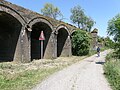
Open arches with water drains

Detail view
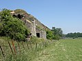
Bunker just before the Rhine

Railway bridge Wesel, postcard 1916

In the foreground the Niederrhein Bridge


In the background the Niederrhein Bridge


See also
literature
- Krabbe: The renewal of the iron superstructures of the railway bridge over the Rhine near Wesel. In: Die Bautechnik , 5th year 1927.
- Ernst: The bridge structures of the Deutsche Reichsbahn. In: Reichsbahn , 4th year 1928, issue 22.
- Hans-P. Höpfner: Railways. Your story on the Lower Rhine. Duisburg 1986.
- Jutta Prieur: History of the city of Wesel. Volume 1, Düsseldorf 1991 / Volume 2, Düsseldorf 1992.
- Ulrich Dinkelaker: Wesel bridgehead. Lünen 1993.
- Alexander Berkel: War on your own doorstep. Rhine crossing and air landing on the Lower Rhine in 1945. Wesel 1994.
- Vincent Freriks: The Venlo - Wesel - Haltern line. In: Railways on the Lower Rhine. (Ed. on behalf of the city of Wesel) Wesel 2005.
- Hans Schlieper, Vincent Freriks: The Boxteler Bahn. The North Brabant German Railway Company and the international Vlissingen postal route. German Society for Railway History eV, Werl 2014, ISBN 978-3-937189-79-6 .
swell
- Annual reports of the Cöln-Mindener Eisenbahn 1865–1876
- Excerpts from the negotiations of the general meetings of the shareholders of the Cöln-Mindener Eisenbahn 1869–1879
Web links
- Description of this sight on the route of industrial culture
- Entry on the Wesel railway bridge in the " KuLaDig " database of the Rhineland Regional Association
Individual evidence
- ^ Centralcommission of the German Empire for the Vienna World Exhibition (ed.): Official report on the Vienna World Exhibition in 1873. Volume 2, Friedrich Vieweg & Sohn, Braunschweig 1874, p. 355.
- ↑ Bloody winter. The last weeks of the Second World War in Kevelaer. In: Blattus.de. Retrieved April 17, 2015 .
Visitor center and anchor points (from west to east): Museum of German Inland Shipping | Inner harbor Duisburg | LVR Industrial Museum Oberhausen | Landscape Park Duisburg-Nord | Gasometer Oberhausen | Aquarius Water Museum | St. Antony Hut | Villa Huegel | Nordsternpark | Zeche Zollverein World Heritage Site and Zollverein Coking Plant | Ewald colliery | Marl Chemical Park | Railway Museum Bochum-Dahlhausen | Henrichshütte | Centennial Hall Bochum | Recklinghausen substation | German Mining Museum | Nightingale colliery | Henrichenburg ship lift | DASA | Hansa coking plant | Zeche Zollern II / IV | Hohenhof | Hagen Open Air Museum | Lindenbrauerei Unna | Maximilian Park Hamm
Themed routes (in ascending order by number): 1. Duisburg: City and Harbor | 2. Industrial cultural landscape Zollverein | 3. Duisburg: industrial culture on the Rhine | 4. Oberhausen: Industry makes the city | 5. Krupp and the city of Essen | 6. Dortmund: triad coal, steel and beer | 7. Industrial culture on the Lippe | 8. Erzbahn-Emscherbruch | 9. Industrial culture at Volme and Ennepe | 10. Brine, steam and coal | 11. Early industrialization | 12. The past and present of the Ruhr | 13. On the way to the blue Emscher | 14. Canals and shipping | 15. Lanes in the area | 16. Westphalian mining route | 17. Rhenish mining route | 18. Chemistry, Glass and Energy | 19. Workers' settlements | 20. Entrepreneur villas | 21. Bread, grain and beer | 22. Myth of the Ruhr Area | 23. Parks and Gardens | 24. Industrial nature | 25. Panoramas and Landmarks | 26. Sacred buildings | 27. Iron & Steel | 28. Water: works, towers and turbines | 29. Bochum - industrial culture in the heart of the district | 30. Gelsenkirchen | 31. Industrial Culture and Bauhaus Route | by bike

Maximilianpark ![]() |
Way to school footbridge |
Werries lock |
Lippe lock Heessen |
Kurpark Hamm |
Water handover Hamm |
Hamm lock |
Klostermühle Pohl |
Water towers on Hellweg |
Hamm train station |
Hamm city harbor |
Zeche Sachsen today Öko-Zentrum NRW |
Vogelsang settlement |
Radbod colliery |
Radbod Colliery Memorial |
Gersteinwerk |
East mine , Heinrich Robert shafts |
Kissinger Höhe
|
Way to school footbridge |
Werries lock |
Lippe lock Heessen |
Kurpark Hamm |
Water handover Hamm |
Hamm lock |
Klostermühle Pohl |
Water towers on Hellweg |
Hamm train station |
Hamm city harbor |
Zeche Sachsen today Öko-Zentrum NRW |
Vogelsang settlement |
Radbod colliery |
Radbod Colliery Memorial |
Gersteinwerk |
East mine , Heinrich Robert shafts |
Kissinger Höhe ![]() |
Ost colliery , shaft Lerche |
Rünthe express train settlement |
Schacht III cultural center |
Marina Rünthe |
Werne colliery | Old office building today Karl-Pollender-Stadtmuseum Werne |
Monopol mine, Grimberg shaft 1/2 |
Heap of large wood
|
Ost colliery , shaft Lerche |
Rünthe express train settlement |
Schacht III cultural center |
Marina Rünthe |
Werne colliery | Old office building today Karl-Pollender-Stadtmuseum Werne |
Monopol mine, Grimberg shaft 1/2 |
Heap of large wood ![]() |
Colliery House Aden |
Seepark Lünen |
"Westfalia" canteen |
Prussia port |
Ziethenstrasse settlement
|
Colliery House Aden |
Seepark Lünen |
"Westfalia" canteen |
Prussia port |
Ziethenstrasse settlement ![]() |
"Am Kanal" settlement |
Victoria Settlement |
Brickwork Siegeroth |
Cappenberg Castle |
Lünen power plant |
Zeche Minister Achenbach , shaft 4 with the LÜNTEC tower |
Miners Residential Museum |
Waltrop colliery |
Waltrop Local History Museum in the Riphaushof |
Old Henrichenburg ship lift
|
"Am Kanal" settlement |
Victoria Settlement |
Brickwork Siegeroth |
Cappenberg Castle |
Lünen power plant |
Zeche Minister Achenbach , shaft 4 with the LÜNTEC tower |
Miners Residential Museum |
Waltrop colliery |
Waltrop Local History Museum in the Riphaushof |
Old Henrichenburg ship lift ![]() in the Waltrop lock park |
Beisenkamp settlement |
Hermann Grochtmann Museum |
Canal cross dates |
Remote control center for water supply Datteln |
Datteln-Natrop lock group |
Canal bridge Alte Fahrt |
"Leaning Bridge" in Olfen |
Canal bridge over the Stever | Former Lippe lock Vogelsang |
Waterworks Haltern of Gelsenwasser AG |
Quartz sand and grinder Haltern-Sythen |
Auguste Victoria Mine Shaft 8 |
Auguste Victoria mine shaft 1/2 |
Auguste Victoria mine shaft 3/7 |
Marl Chemical Park
in the Waltrop lock park |
Beisenkamp settlement |
Hermann Grochtmann Museum |
Canal cross dates |
Remote control center for water supply Datteln |
Datteln-Natrop lock group |
Canal bridge Alte Fahrt |
"Leaning Bridge" in Olfen |
Canal bridge over the Stever | Former Lippe lock Vogelsang |
Waterworks Haltern of Gelsenwasser AG |
Quartz sand and grinder Haltern-Sythen |
Auguste Victoria Mine Shaft 8 |
Auguste Victoria mine shaft 1/2 |
Auguste Victoria mine shaft 3/7 |
Marl Chemical Park ![]() |
Ready settlement ( Marl ) of the chemical works Hüls |
Brassert settlement |
Auguste Victoria colliery , shaft 4/5 |
Loemühle Airport |
Ruhrgas Dorsten |
Prince Leopold Mine |
Fürst Leopold settlement |
Dorsten lock group |
Dorsten station |
Gahlenscher Kohlenweg |
Dorsten-Holsterhausen waterworks |
Tüshaus-Mühle |
Menting earth building |
Roof tile works Nelskamp | Lippe-Treidlerdorf Krudenburg |
Black Heath Airfield |
Friedrichsfeld lock group | Former Lippe Harbor Wesel |
Old waterworks Wesel |
Water tower Wesel |
Rhine bridge Wesel |
Municipal Rhine port of Wesel |
Prussia Museum Wesel
|
Ready settlement ( Marl ) of the chemical works Hüls |
Brassert settlement |
Auguste Victoria colliery , shaft 4/5 |
Loemühle Airport |
Ruhrgas Dorsten |
Prince Leopold Mine |
Fürst Leopold settlement |
Dorsten lock group |
Dorsten station |
Gahlenscher Kohlenweg |
Dorsten-Holsterhausen waterworks |
Tüshaus-Mühle |
Menting earth building |
Roof tile works Nelskamp | Lippe-Treidlerdorf Krudenburg |
Black Heath Airfield |
Friedrichsfeld lock group | Former Lippe Harbor Wesel |
Old waterworks Wesel |
Water tower Wesel |
Rhine bridge Wesel |
Municipal Rhine port of Wesel |
Prussia Museum Wesel
Railway Museum Bochum-Dahlhausen ![]() |
Dahlhausen railway station |
Hattingen train station |
Ruhr Valley Railway |
Henrichshütte
|
Dahlhausen railway station |
Hattingen train station |
Ruhr Valley Railway |
Henrichshütte ![]() |
Railway line Hattingen - Schee - Silschede with the Sprockhövel train station |
Ennepetal station |
Kruiner Tunnel |
Haspe - Voerde - Breckerfeld railway line |
Harkort coal railway |
Viaduct of the Rheinische Eisenbahngesellschaft |
Goldberg tunnel |
Hagen Central Station |
Ruhr-Sieg route |
Herdecke Ruhr Viaduct |
Railway repair shop Schwerte and Kreinberg settlement |
Upper Ruhr Valley Railway and Langschede Station |
Hamm train station |
Kamen train station |
Seseke Bridge |
Immermannstrasse depot |
Local Transport Museum Dortmund |
Turnout construction hall machine factory Germany |
Dortmund Central Station |
Dortmund railway bridge ensemble |
Dortmund depot |
Water tower Dortmund Südbahnhof |
Zeche Zollern II / IV
|
Railway line Hattingen - Schee - Silschede with the Sprockhövel train station |
Ennepetal station |
Kruiner Tunnel |
Haspe - Voerde - Breckerfeld railway line |
Harkort coal railway |
Viaduct of the Rheinische Eisenbahngesellschaft |
Goldberg tunnel |
Hagen Central Station |
Ruhr-Sieg route |
Herdecke Ruhr Viaduct |
Railway repair shop Schwerte and Kreinberg settlement |
Upper Ruhr Valley Railway and Langschede Station |
Hamm train station |
Kamen train station |
Seseke Bridge |
Immermannstrasse depot |
Local Transport Museum Dortmund |
Turnout construction hall machine factory Germany |
Dortmund Central Station |
Dortmund railway bridge ensemble |
Dortmund depot |
Water tower Dortmund Südbahnhof |
Zeche Zollern II / IV ![]() |
Recklinghausen Central Station |
Herne train station |
Wanne-Eickel main station |
Local history and natural history museum Wanne-Eickel |
Railway depot Gelsenkirchen-Bismarck |
Gelsenkirchen Central Station |
Dorsten station |
RBH Logistics |
Werksbahn Bochumer Verein and Erzbahn |
Bochum Association |
Bochum Nord railway station and steel bridges of the Rheinische Bahn |
Bochum Central Station |
BOGESTRA head office |
Langendreer train station (with the cultural center ) |
Tram depot Witten and garden city Crengeldanz |
Switch factory Witten |
Witten Central Station |
Ruhr Viaduct Witten |
Mine and field railway museum Zeche Theresia | Railway systems of the Nachtigall colliery
|
Recklinghausen Central Station |
Herne train station |
Wanne-Eickel main station |
Local history and natural history museum Wanne-Eickel |
Railway depot Gelsenkirchen-Bismarck |
Gelsenkirchen Central Station |
Dorsten station |
RBH Logistics |
Werksbahn Bochumer Verein and Erzbahn |
Bochum Association |
Bochum Nord railway station and steel bridges of the Rheinische Bahn |
Bochum Central Station |
BOGESTRA head office |
Langendreer train station (with the cultural center ) |
Tram depot Witten and garden city Crengeldanz |
Switch factory Witten |
Witten Central Station |
Ruhr Viaduct Witten |
Mine and field railway museum Zeche Theresia | Railway systems of the Nachtigall colliery ![]() and the Muttental |
Zollverein station |
Rheinische Bahn in Essen |
Locomotive factory and works railway Krupp |
Essen Central Station |
Railway Headquarters Essen |
Villa Hügel
and the Muttental |
Zollverein station |
Rheinische Bahn in Essen |
Locomotive factory and works railway Krupp |
Essen Central Station |
Railway Headquarters Essen |
Villa Hügel ![]() and train station Essen-Hügel |
Ruhr Bridge Steele |
Kupferdreh station and Hespertalbahn museum railway | " Hundebrücke " and " Deilthaler Eisenbahn " |
Kettwig railway bridge |
City viaduct and Ruhr bridge Mülheim |
Roundhouse and Camera Obscura |
Railway repair shop Speldorf with the old turning shop |
Tram depot Speldorf |
Bridge landscape Ruhraue |
Shunting yard , railway repair shop Wedau and railway settlement Wedau |
Water Tower Rheinhausen-Friemersheim and railway settlement Rheinhausen-Friemersheim |
Duisburg-Hochfelder Railway Bridge |
Lifting tower "Homberg-Ruhrorter Rheintrajektanstalt" |
Duisburg Central Station |
Green path |
HOAG route |
Thyssen works railway |
House Knipp Railway Bridge |
Rhine bridge Wesel |
Oberhausen Central Station |
LVR Industrial Museum Oberhausen
and train station Essen-Hügel |
Ruhr Bridge Steele |
Kupferdreh station and Hespertalbahn museum railway | " Hundebrücke " and " Deilthaler Eisenbahn " |
Kettwig railway bridge |
City viaduct and Ruhr bridge Mülheim |
Roundhouse and Camera Obscura |
Railway repair shop Speldorf with the old turning shop |
Tram depot Speldorf |
Bridge landscape Ruhraue |
Shunting yard , railway repair shop Wedau and railway settlement Wedau |
Water Tower Rheinhausen-Friemersheim and railway settlement Rheinhausen-Friemersheim |
Duisburg-Hochfelder Railway Bridge |
Lifting tower "Homberg-Ruhrorter Rheintrajektanstalt" |
Duisburg Central Station |
Green path |
HOAG route |
Thyssen works railway |
House Knipp Railway Bridge |
Rhine bridge Wesel |
Oberhausen Central Station |
LVR Industrial Museum Oberhausen ![]()
|
The next bridge upstream: Niederrheinbrücke Wesel |
Bridges over the Rhine |
The next bridge downstream: Rhine bridge Rees-Kalkar |
Coordinates: 51 ° 39 ′ 11 " N , 6 ° 35 ′ 27.9" E