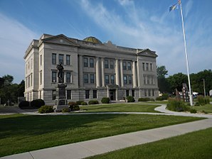
Grant County, South Dakota
 Grant County Courthouse |
|
| administration | |
|---|---|
| US state : | South Dakota |
| Administrative headquarters : | Milbank |
| Address of the administrative headquarters: |
Grant County Courthouse 210 East 5th Avenue Milbank, SD 57252-2433 |
| Foundation : | 1873 |
| Made up from: | Codington and Deuel Counties |
| Area code : | 001 605 |
| Demographics | |
| Residents : | 7356 (2010) |
| Population density : | 4.2 inhabitants / km 2 |
| geography | |
| Total area : | 1782 km² |
| Water surface : | 14 km² |
| map | |
The Grant County is a county in the US -amerikanischen State South Dakota . In 2010 , the county had 7,356 residents and a population density of 4.2 people per square kilometer. The county seat is Milbank .
geography
The county is located in northeast South Dakota on the Coteau des Prairies on the border with Minnesota , which is formed in the northeast by Big Stone Lake . 'It is traversed by the Whetstone River and the two arms of the Yellow Bank River , all of which are right tributaries of the Minnesota River .
The county covers an area of 1782 square kilometers, divided into 1768 square kilometers of land and 14 square kilometers (0.78 percent) of water.
The following neighboring counties border Grant County:
| Roberts County |
Big Stone County, Minnesota |
|
| Day County |

|
Lac qui Parle County, Minnesota |
| Codington County | Deuel County |
The northwestern portion of the county is occupied by the Lake Traverse Indian Reservation area. The Indian reservation is home to the Sisseton Wahpeton Oyate , a subgroup of the Dakota . The reservation area spans several counties in South Dakota and North Dakota.
history
Grant County was formed on January 8, 1878, and its administrative organization was completed on June 17, 1878. It was named after Ulysses S. Grant (1822-1885), commander in chief of Union troops in the Civil War and later 18th President of America.
But after it was first administered from Deuel County, its own administration was set up in June 1978. The first administrative seat was in Inkpa City . Milbank , along with three other localities, later became a candidate for the new administrative headquarters and ultimately won the competition for it.

15 buildings and sites in the county are listed on the National Register of Historic Places (NRHP) (as of July 31, 2018).
| Population development | |||
|---|---|---|---|
| Census | Residents | ± in% | |
| 1900 | 9103 | - | |
| 1910 | 10.303 | 13.2% | |
| 1920 | 10,880 | 5.6% | |
| 1930 | 10,729 | -1.4% | |
| 1940 | 10,552 | -1.6% | |
| 1950 | 10,233 | -3% | |
| 1960 | 9913 | -3.1% | |
| 1970 | 9005 | -9.2% | |
| 1980 | 9013 | 0.1% | |
| 1990 | 8372 | -7.1% | |
| 2000 | 7847 | -6.3% | |
| 2010 | 7356 | -6.3% | |
| 2012 estimate | 10.303 | 40.1% | |
| 1900–1990 2000 2010–2012 | |||
Demographic data
According to the 2010 census , Grant County had 7,356 people in 3,180 households. The population density was 4.2 inhabitants per square kilometer. Statistically, 2.22 people lived in each of the 3180 households.
The racial the population was composed of 97.4 percent white, 0.4 percent African American, 0.8 percent Native American, 0.4 percent Asian and other ethnic groups; 0.9 percent were descended from two or more races. Regardless of ethnicity, 2.5 percent of the population was Hispanic or Latino of any race.
22.2 percent of the population were under 18 years old, 58.2 percent were between 18 and 64 and 19.6 percent were 65 years or older. 49.1 percent of the population was female.
The median income for a household was 44,444 USD . The per capita income was $ 24,344. 12.6 percent of the population lived below the poverty line.
Grant County localities
structure
In addition to the two cities and seven towns, Grant County is divided into 17 townships :
|
|
See also
Individual evidence
- ^ Grant County in the United States Geological Survey's Geographic Names Information System.Retrieved February 22, 2011
- ↑ a b c U.S. Census Bureau, State & County QuickFacts - Grant County, SD ( Memento of the original from July 10, 2011 on WebCite ) Info: The archive link was automatically inserted and not yet checked. Please check the original and archive link according to the instructions and then remove this notice. Retrieved July 18, 2013
- ^ A b National Association of Counties. Retrieved July 18, 2013
- ↑ Charles Curry Aiken, Joseph Nathan Kane: The American Counties: Origins of County Names, Dates of Creation, Area, and Population Data, 1950-2010 . 6th edition. Scarecrow Press, Lanham 2013, ISBN 978-0-8108-8762-6 , p. 118 .
- ^ E-ReferenceDesk - Grant County.Retrieved July 18, 2013
- ↑ Search mask database in the National Register Information System. National Park Service , accessed July 31, 2018.
- ^ Extract from Census.gov.Retrieved February 28, 2011
- ↑ Missouri Census Data Center - South Dakota ( page no longer available , search in web archives ) Info: The link was automatically marked as defective. Please check the link according to the instructions and then remove this notice. Retrieved July 18, 2013
Web links
Coordinates: 45 ° 10 ′ N , 96 ° 46 ′ W

