
Stephanskirchen
| coat of arms | Germany map | |
|---|---|---|

|
Coordinates: 47 ° 51 ' N , 12 ° 11' E |
|
| Basic data | ||
| State : | Bavaria | |
| Administrative region : | Upper Bavaria | |
| County : | Rosenheim | |
| Height : | 440 m above sea level NHN | |
| Area : | 26.51 km 2 | |
| Residents: | 10,593 (Dec 31, 2019) | |
| Population density : | 400 inhabitants per km 2 | |
| Postal code : | 83071 | |
| Primaries : | 08031, 08036 | |
| License plate : | RO , AIB , WS | |
| Community key : | 09 1 87 177 | |
| LOCODE : | DE SKN | |
| Community structure: | 48 districts | |
| Address of the municipal administration: |
Rathausplatz 1 (Schloßberg) 83071 Stephanskirchen |
|
| Website : | ||
| Mayor : | Karl Mair (Free Citizens of Stephankirchen) | |
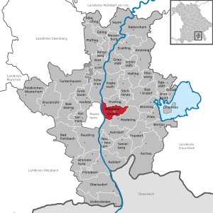
| Location of the municipality of Stephanskirchen in the district of Rosenheim | ||
  |
||

Stephanskirchen is one of the largest communities in the Upper Bavarian district of Rosenheim . The town hall and the administrative headquarters are in the Schloßberg district. Stephanskirchen is one of the five Simssee communities with Bad Endorf , Riedering , Prutting and Söchtenau .
geography
Geographical location


The community is located on a glacial plateau and is bounded in the west by the Inn and in the east by the Simssee . The valley of the Sims is the natural southern border, in the north there are forest areas with several small lakes. Stephanskirchen is located within the Rosenheim basin in the area of the former Inn Glacier . There are therefore numerous erratic boulders in the municipality .
Neighboring communities
| Schechen , Vogtareuth | Prutting | Bad Endorf |
| Rosenheim |
.svg)
|
Riedering |
| Rohrdorf | Riedering |
Community structure
Stephanskirchen has 48 districts:
history


The oldest traces date to the third and fourth millennium BC. BC and can be found in Doblergraben and on Ziegelberg. A Roman road crossed the Inn at Leonhardspfunzen on the "pons aeni" and ran west to Augsburg. The first Christian church "ecclesia ad sinsa" is reported in 790 in the area around Sims. In 1130 the village of Stephanskirchen was first mentioned in a document as "stevenchirgen". Rosenheim Castle , also called Rosenheim Castle, was located on the Schlossberg . Mentioned for the first time in 1232, it served as the administrative and court seat of the Wittelsbach family ; it fell into disrepair at the beginning of the 19th century.
The plague epidemics of the Middle Ages also took their toll in Stephanskirchen. In the forest between Kieling and Baierbach there is a memorial stone in memory of those buried there. The inscription on the plaque reads:
During the Thirty Years' War in 1632 the plague raged in the surrounding areas. Many people died from this disease and were buried in mass graves here in this quiet place. According to tradition, entire villages have died out. Only one little girl was left in Kieling. This stone cross was erected in memory of the dead. (Historically handed down by Pastor Angerer, Stephanskirchen).
In the main teams Gehering and Stephanskirchen, forerunners of today's municipality of Stephanskirchen, rural structures prevailed until the 18th century. Stephanskirchen and the newly created workers 'and day laborers' settlement Hofleiten became independent political communities in the course of the administrative reforms in Bavaria in 1818. In 1854 Hofleiten and Stephanskirchen were united. Due to the social differences there were violent clashes between the different parts of the community until the late 19th century. Since 1900, Schloßberg has become the largest town in the municipality due to its proximity to Rosenheim.
From December 4, 1944 to March 31, 1945, there was a subcamp of the Dachau concentration camp in the district of Haidholzen , in which around 200 concentration camp prisoners performed forced labor . The Polish, Russian and French prisoners of war were housed in a barracks settlement on the premises of the local flak barracks. The main building of this flak barracks still exists today, and since 1947 the production facilities of a confectionery factory have been located there. The prisoners worked for regional clients and for the Chiemgauer Vertriebsgesellschaft OHG, a branch of the BMW company that manufactured aircraft engines in Stephanskirchen, but never fully started operations. Several independent sources indicate that prisoners were also murdered in the Stephanskirchen subcamp. Towards the end of 1944 the plant was the target of air raids in which two members of the workforce were killed. 30% of the building stock and 20% of the machinery were destroyed, resulting in damage of 250,000 RM. On the orders of Heinrich Himmler , an evacuation to the rear concentration camps was carried out in March and April 1945, during which many prisoners died from exhaustion or were shot by the SS.
After the Second World War, around 1,500 refugees and expellees came to Stephanskirchen and founded the Haidholzen settlement near the barracks. Street names such as “Schlesierstraße” or “Sudetenlandstraße” still indicate the origin of these displaced persons. In 2003 a new town hall was opened in Schloßberg.
Population development
Between 1988 and 2018 the municipality grew from 9,035 to 10,528 by 1,493 inhabitants or 16.5%.
politics
Municipal council
The 2014 local elections resulted in the following distribution of seats in the Stephanskirchen municipal council :
| Party / list | 2014 |
|---|---|
| CSU | 9 |
| Party-free citizens (PfB) | 4th |
| SPD | 3 |
| Green | 2 |
| BP | 2 |
| total | 20th |
coat of arms
The municipal coat of arms, designed in 1954, indicates the historical division of the municipality into two parts: At the top, Saint Stephen symbolizes the St. Stephen 's Church with a golden halo . He is holding a gold missal with three gold stones in his left arm. In the lower part of the coat of arms a boat , a so-called hat, reminds of the former sources of income in Schloßberg, Hofleiten and the districts on the banks of the Inn: shipping and fishing. The green dominating in the coat of arms is an indication of the agricultural structure of the municipality.
Attractions
- Largest art clock in the world in the wine bar at Gocklwirt (builder: Josef Kreß 1880–1886)
- Church of St. Magdalena in Baierbach
- Church of the 14 Holy Helpers in Kleinholzen
- St. Leonhardskirche in Leonhardspfunzen
- Well chapel in Leonhardspfunzen
- Innleiten Castle, built in 1894 by Thomas Gillizer in neo-baroque style in the district of Innleiten
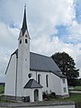
Filial church St. Magdalena in Baierbach
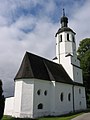
Church of the 14 Holy Helpers in Kleinholzen
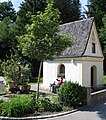
Well chapel and spring; St. Leonhard

Innleiten Castle


Economy and Infrastructure
traffic
Stephanskirchen is on State Road 2362, which provides a direct connection to Rosenheim . The A 8 can be reached from Rosenheim via the B 15 .
The Munich – Salzburg railway runs through the municipality of Stephanskirchen . It is listed in the course book of Deutsche Bahn as course book route 951. The station was put into operation on May 7, 1860 as a crossing station on the railway line, which had only been built with a single track. In addition to the main track, the station also had a siding , which could be omitted with the double-track expansion of the line. The station was later expanded by adding scales, a loading ramp, a wagon turntable and sidings. The points were set manually on both sides. On May 31, 1981, the passenger train service was discontinued due to too few passengers. Most recently, the station was rarely served by passenger trains, which mostly ran from Rosenheim to Freilassing. On November 25, 1985, freight traffic was finally stopped and the station shut down. The reception building is used privately today.
Today the municipality of Stephanskirchen is only served by three bus routes of the Regionalverkehr Oberbayern (RVO). The 9496 bus runs from Monday to Friday from Rosenheim via Stephanskirchen and Riedering to Aschau im Chiemgau approximately every two hours. Individual buses run on Saturdays, but there is no operation on Sundays. Line 9497 also runs from Monday to Friday approximately every two hours and connects the Rosenheim train station with Stephanskirchen, Riedering, Rimsting and the Prien am Chiemsee train station . On Saturdays there are only two buses on the 9497 bus line, there is no service on Sundays. The 9498 bus only runs between Rosenheim and Stephanskirchen. From Monday to Friday this runs approximately every two hours. Individual buses run on Saturdays, but there is no operation on Sundays.
Established businesses
- Arnold & Richter Cine Technik GmbH & Co Betriebs KG
- Hamberger Industriewerke
- Marc O'Polo GmbH
- St. Leonhards
Schools and kindergartens

The elementary and secondary school in the Stephanskirchen district is now located in a building complex built in 1978, with which the school was significantly expanded; it was named in honor of the Haidholzen-based author Otfried Preußler († 2013), who worked from 1953 to 1970 first as an elementary school teacher, then as principal at this school, in the Otfried Preußler School. It is currently the only cooperating UNESCO project school of all primary schools in Bavaria. Around 550 students are spread over a total of 25 classes. The primary school comprises eight classes, the secondary school 17 classes, six of which are in the secondary school. Afternoon care at the elementary school is offered by the “KinderArche” association.
The Dr. Houghton e. V. ran the Sonnenholzschule in the late 1970s. Later the school moved to the Elkofen country school home.
The Schloßberg elementary school is located in the Schloßberg district, a two-tier primary school for around 200 students.
The community also has five kindergartens with crèches: The Catholic kindergarten “St. Georg "in Schloßberg, the Catholic kindergarten" Sonnenschein "and the house for children" Räuber Hotzenplotz "of the AWO in Haidholzen, the Catholic parish kindergarten" Bärenstube "in Stephanskirchen and the Protestant kindergarten" Regenbogen "in Schloßberg.
Personalities
- Manfred Bacher (1923–1994), author ("There are rascals", "It's always been me", play: "The land consolidation")
- Nikolaus Graf zu Dohna-Schlodien (1879–1956), naval officer, leader of a volunteer corps and writer , lived in Baierbach from the mid-1930s until his death
- Ernst Hannawald (* 1959), actor
- Armin Kratzert (* 1957), writer, grew up in Stephanskirchen
- Rainer Krug, (* 1968) Vice World Champion Snowboard 1996
- Erika Maria Lankes, (* 1940) sculptor, including the 2003 Culture Prize of the City of Rosenheim, lives in Stephanskirchen
- Franz Neubauer (1930–2015), politician (CSU), former member of the state parliament and Bavarian. Minister of State for Labor and Social Affairs, 1984–1986 Chairman of the Sudeten German Landsmannschaft
- Otfried Preußler (1923–2013), children's book author (" Krabat ", " The Little Witch ", " The Robber Hotzenplotz ")
- Hermann Zenz (1926–2009), CSU politician, MP (MDL), lived in Stephanskirchen
Individual evidence
- ↑ "Data 2" sheet, Statistical Report A1200C 202041 Population of the municipalities, districts and administrative districts 1st quarter 2020 (population based on the 2011 census) ( help ).
- ↑ Our mayors
- ↑ http://www.bayerische-landesbibliothek-online.de/orte/ortssuche_action.html ? Anzeige=voll&modus=automat&tempus=+20111023/123447&attr=OBJ&val= 531
- ↑ Memorial sites for the victims of National Socialism. A documentation, volume 1. Federal Agency for Civic Education , Bonn 1995, ISBN 3-89331-208-0 , p. 194
- ↑ Rosenheim in the Third Reich; Contributions to the history of the city, published by the cultural office of the city of Rosenheim in 1989
- ↑ History of the company PIT Süßwaren Online on the homepage
- ↑ House of Bavarian History Online ( page no longer available , search in web archives ) Info: The link was automatically marked as defective. Please check the link according to the instructions and then remove this notice.
- ^ Armin Franzke, Josef Mauerer: 1860-2010: 150 years of the Rosenheim - Salzburg line . PB Service, Munich 2010, ISBN 978-3-9812639-2-3 , p. 125 .
- ^ Armin Franzke, Josef Mauerer: 1860-2010: 150 years of the Rosenheim - Salzburg line . PB Service, Munich 2010, ISBN 978-3-9812639-2-3 , p. 125-126 .
- ^ Siegfried Bufe: Main line Munich – Salzburg . Bufe-Fachbuch-Verlag, Egglham 1995, ISBN 3-922138-57-8 .
- ↑ Line network of regional transport Upper Bavaria (PDF; 2.1 MB) In: rvo-bus.de . RVO. 2011. Archived from the original on March 19, 2013. Info: The archive link was inserted automatically and has not yet been checked. Please check the original and archive link according to the instructions and then remove this notice. Retrieved April 1, 2013.
- ↑ Communal brochure of the Stephanskirchen congregation PDF file, 12 MB
- ↑ Erika Maria Lankes
Web links
- Entry on the coat of arms of Stephanskirchen in the database of the House of Bavarian History
- History of the Stephanskirchen community on the community website
- Stephanskirchen: Official statistics of the LfStat

Albaching | Amerang | Aschau im Chiemgau | Babensham | Bad Aibling | Bad Endorf | Bad Feilnbach | Bernau am Chiemsee | Brannenburg | Breitbrunn am Chiemsee | Bruckmühl | Chiemsee | Edling | Eggstätt | Eiselfing | Feldkirchen-Westerham | Flintsbach am Inn | Frasdorf | Griesstätt | Großkarolinenfeld | Gstadt am Chiemsee | Halfing | Höslwang | Kiefersfelden | Kolbermoor | New building | Nussdorf am Inn | Oberaudorf | Pfaffing | Prien am Chiemsee | Prutting | Ramerberg | Raubling | Riedering | Rimsting | Rohrdorf | Rott am Inn | Samerberg | Schechen | Schonstett | Söchtenau | Soyen | Stephanskirchen | Tuntenhausen | Vogtareuth | Wasserburg am Inn
Unregulated areas in the district of Rosenheim
Rotter Forst-Nord |
Rotter Forst-Süd