
District of Hersfeld-Rotenburg
| coat of arms | Germany map |
|---|---|

|

Coordinates: 50 ° 52 ' N , 9 ° 43' E |
| Basic data | |
| State : | Hesse |
| Administrative region : | kassel |
| Administrative headquarters : | Bad Hersfeld |
| Area : | 1,097.12 km 2 |
| Residents: | 120,719 (Dec. 31, 2019) |
| Population density : | 110 inhabitants per km 2 |
| License plate : | HEF, ROF |
| Circle key : | 06 6 32 |
| NUTS : | DE733 |
| Circle structure: | 20 municipalities |
| Address of the district administration: |
Friedloser Strasse 12 36251 Bad Hersfeld |
| Website : | |
| District Administrator : | Michael Koch ( CDU ) |
| Location of the district of Hersfeld-Rotenburg in Hesse | |
  |
|
The district of Hersfeld-Rotenburg is located in the administrative district of Kassel with areas in northern Hesse (old district Rotenburg) and eastern Hesse ( old district Hersfeld ).
In the tourist area, the name Waldhessen has become natural for the district .
geography
location
The district area essentially comprises the middle Fulda valley. To the west of it the heights of the Knüllgebirge (sometimes called Knüll ) rise , to the east the heights of the Werra-Fulda-Bergland with the Seulingswald . The highest point in the district is the Eisenberg (636 m) in the Hochknüll.
In the south are the northern foothills of the Rhön . The east of the district around Heringen (Werra) touched by the Werra is part of the Werra potash district .
Neighboring areas
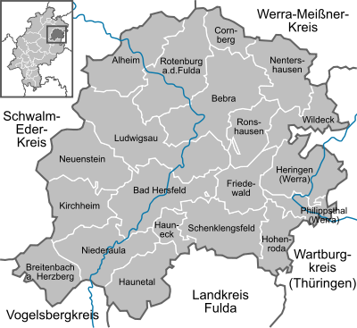
The district borders clockwise in the northeast, beginning with the districts Werra-Meißner-Kreis (in Hesse), Wartburgkreis (in Thuringia ), Fulda , Vogelsbergkreis and Schwalm-Eder-Kreis (both in turn in Hesse).
history
Today's district area belonged very early to the Landgraviate of Hesse , which later became the Electorate of Hesse. The region around Rotenburg had belonged to Hesse since the 13th century, and the clerical principality of Hersfeld followed in the course of the 16th century. The two offices of Hersfeld (within the province of Fulda) and Rotenburg (within the province of Niederhessen ) were established here at the beginning of the 19th century . Circles were formed from the offices in 1821 .
As part of the regional reform in Hesse , the new district of Hersfeld-Rotenburg was created on August 1, 1972. He was educated from
- the district of Hersfeld
- the district of Rotenburg to the city Sontra that the district Eschwege came, and the community Rengshausen that the district Fritzlar-Homberg was assigned
- the communities of Bodes , Erdmannrode , Fischbach , Haunetal and Unterstoppel from the district of Hünfeld
- the municipality of Heinebach from the district of Melsungen and
- the municipality of Breitenbach am Herzberg from the district of Ziegenhain .
At the same time as the district was founded, the administrative structure that still exists today was created through a series of municipal mergers.
Population development
| year | Residents | source |
|---|---|---|
| 1975 | 131,400 | |
| 1980 | 127,700 | |
| 1990 | 129,200 | |
| 2000 | 130,654 | |
| 2010 | 122,449 | |
| 2015 | 119.216 | |
| 2018 | 120,949 |
politics
District council
The local elections on March 6, 2016 produced the following results, compared to previous local elections:
| Diagram showing the election results and the distribution of seats | |
|---|---|
|
Election of the Hersfeld-Rotenburg district assembly in 2016
% 40 30th 20th 10
0
36.9%
30.0%
12.4%
6.9%
5.9%
5.1%
2.8%
n. k.
Gains and losses
|
|
| Nominations | % 2016 |
Seats 2016 |
% 2011 |
Seats 2011 |
% 2006 |
Seats 2006 |
% 2001 |
Seats 2001 |
|
|---|---|---|---|---|---|---|---|---|---|
| SPD | Social Democratic Party of Germany | 36.9 | 22nd | 42.9 | 26th | 48.1 | 29 | 50.7 | 31 |
| CDU | Christian Democratic Union of Germany | 30.0 | 18th | 34.1 | 21st | 37.2 | 23 | 35.4 | 21st |
| AfD | Alternative for Germany | 12.4 | 8th | - | - | - | - | - | - |
| FWG FREE VOTERS | Free voter association FREIE VÄHLER Hersfeld-Rotenburg eV |
6.9 | 4th | 5.8 | 4th | 4.5 | 3 | 4.4 | 3 |
| GREEN | Alliance 90 / The Greens | 5.9 | 4th | 10.2 | 6th | 2.9 | 2 | 4.0 | 2 |
| FDP | Free Democratic Party | 5.1 | 3 | 3.6 | 2 | 3.0 | 2 | 2.8 | 2 |
| THE LEFT. | THE LEFT. | 2.8 | 2 | 2.5 | 1 | 1.9 | 1 | - | - |
| FL | Free list | - | - | 0.9 | 1 | - | - | - | - |
| Independent | Independent electoral alternative Hersfeld-Rotenburg | - | - | - | - | 1.4 | 1 | - | - |
| REP | The Republicans | - | - | - | - | - | - | 2.8 | 2 |
| total | 100.0 | 61 | 100.0 | 61 | 100.0 | 61 | 100.0 | 61 | |
| Voter turnout in% | 53.9 | 52.0 | 54.2 | 61.1 | |||||
Shortly after the election, the two AfD MPs Bernd Ebhardt and Axel von Baumbach resigned from their mandates. Information and photos emerged from von Baumbach that showed how he was appointed “Minister of the Interior of the German Reich” and thus part of the “provisional Reich government” by a self-declared Reich Citizen Leader. Bernd Eberhardt resigned from his mandate because his Facebook profile, which was heavily marked by “references to right-wing extremist and anti-Semitic Internet publications” and “brown conspiracy theories ”, had called for Angela Merkel to be hanged and declared his solidarity with a convicted Holocaust denier would have. Other candidates moved up so that the AfD parliamentary group in the district council still consists of eight people.
District Administrator

The first direct election of a district administrator took place on March 2, 1997. Here the SPD candidate, Roland Hühn, prevailed against a CDU candidate with 57.2 percent of the vote. In the next election on February 2, 2003, Karl-Ernst Schmidt from the CDU competed against District Administrator Roland Hühn and won the election with 50.3 percent of the vote. District Administrator Karl-Ernst Schmidt was re-elected on April 26, 2009 with 59.8% of the vote, Manfred Koch was a candidate for the SPD.
On March 29, 2015, Michael Koch (CDU) was elected district administrator with 58.4% of the votes. He prevailed in the runoff election against Elke Künholz (SPD). Werner David (FDP), Alexander Sauer and Jörg Brand (both non-party) failed in the first ballot on March 15, 2015.
Coat of arms, flag and banner
| Banner, coat of arms and flag | |

|
|

|
|
|
|
Blazon : "Split of silver and red, in front a faceted double-paw cross, behind a horizontal silver branch from which a branch with three silver linden leaves grows" |
| Reasons for the coat of arms: The faceted double paw cross is the red Hersfeld double cross , the symbol of the old Hersfeld monastery, the linden branch is the coat of arms of the city of Rotenburg an der Fulda. The symbols symbolize the two former district towns. The earlier district coats of arms also bore these symbols. The coat of arms was approved on March 29, 1976. |
Economy and Transport
economy
In the future atlas 2016 , the district of Hersfeld-Rotenburg took 211th place out of 402 districts, municipal associations and independent cities in Germany and is therefore one of the regions with a "balanced risk-opportunity mix" for the future.
railroad
Bad Hersfeld and Bebra are long-distance train stations that are served by the Intercity and, in some cases, the Intercity Express .
In Bebra, the middle-Germany connection between the Ruhr area, Kassel, Erfurt, Chemnitz / Leipzig and the old north-south route Hanover and Frankfurt / Würzburg intersect .
The high-speed route Hanover – Würzburg runs through the district without stopping. Connection curves to Bebra or Bad Hersfeld as a connection to Erfurt are planned for the long term.
Street
The federal highways 7 (Würzburg – Kassel), 5 (Frankfurt – Hattenbacher Dreieck (end of the A 5)) and 4 (Kirchheimer Dreieck – Erfurt) run through the district . Furthermore, several federal, state and district roads open up the district area, including the B 27 , the B 62 and the B 83 .
Communities
(Population figures as of December 31, 2019)
|
|
  |
Sponsorship

In 1954 the sponsorship for the expelled Sudeten Germans from the Mährisch Schönberg district was taken over.
License Plate
On August 1, 1972, the district was assigned the HEF distinctive sign , which had been valid for the Hersfeld district since July 1, 1956 . It is still issued today.
For a while, vehicles from the old district of Rotenburg were given license plates with the letter pairs PA to ZZ and the numbers from 1 to 99, later also 100 to 999.
Since August 1, 2013, the distinguishing mark ROF (Rotenburg an der Fulda) has also been available.
Web links
- Official website of the district of Hersfeld-Rotenburg
- District of Hersfeld-Rotenburg. Historical local dictionary. In: Landesgeschichtliches Informationssystem Hessen (LAGIS).
- Komm-in-die-mitte.de: Informative website about all areas of life in the Hersfeld-Rotenburg district
- Link catalog on the topic of the Hersfeld-Rotenburg district at curlie.org (formerly DMOZ )
Individual evidence
- ↑ Hessian State Statistical Office: Population status on December 31, 2019 (districts and urban districts as well as municipalities, population figures based on the 2011 census) ( help ).
- ^ Federal Statistical Office (ed.): Historical municipality directory for the Federal Republic of Germany. Name, border and key number changes in municipalities, counties and administrative districts from May 27, 1970 to December 31, 1982 . W. Kohlhammer, Stuttgart / Mainz 1983, ISBN 3-17-003263-1 , p. 413 f .
- ^ Hersfeld-Rotenburg district. Historical local dictionary. In: Landesgeschichtliches Informationssystem Hessen (LAGIS).
- ↑ Law on the reorganization of the districts of Hersfeld and Rothenburg (GVBl. II No. 330-13) of July 11, 1972 . In: The Hessian Minister of the Interior (ed.): Law and Ordinance Gazette for the State of Hesse . 1972 No. 17 , p. 217 , § 17 ( online at the information system of the Hessian state parliament [PDF; 1,2 MB ]).
- ↑ Statistical Yearbook for the Federal Republic of Germany 1976
- ^ A b Michael Rademacher: German administrative history from the unification of the empire in 1871 to the reunification in 1990. District of Hersfeld-Rotenburg. (Online material for the dissertation, Osnabrück 2006).
- ↑ Hessian State Statistical Office
- ↑ Population in the administrative districts on September 30, 2010 and population processes in the 3rd quarter of 2010. Hessian State Statistical Office, archived from the original on May 10, 2011 ; accessed on May 31, 2019 .
- ↑ Population in the administrative districts on June 30, 2015 and change in population in the 2nd quarter of 2015. Hessian State Statistical Office, archived from the original on March 24, 2016 ; accessed on May 31, 2019 .
- ↑ The population of the Hessian municipalities on June 30, 2018, Hessisches Statistisches Landesamt ( online ; in the web archive )
- ^ Hessian State Statistical Office: Results of the district elections of 2016 and 2011
- ^ Hessian State Statistical Office: Results of the district elections of 2011 and 2006
- ^ Hessian State Statistical Office: Results of the district elections of 2006 and 2001
- ^ Hessian State Statistical Office: Results of the district elections of 2001 and 1997
- ↑ The group of free Germans won no seat in 2006, but won 1.0% of the votes.
- ^ A b Carsten Meyer, Joachim F. Tornau: "Reich Citizens Movement" - AfD MPs begin to withdraw. Frankfurter Rundschau , March 17, 2016, accessed on November 28, 2017 .
- ^ Maximillian Holscher: "Reich Minister of the Interior": AfD deputy is a member of a dubious group. Hessische / Niedersächsische Allgemeine , March 17, 2016, accessed on November 28, 2017 .
- ^ Members - District of Hersfeld-Rotenburg. Retrieved November 28, 2017 (German).
- ↑ Zukunftsatlas 2016. Archived from the original ; accessed on March 23, 2018 .
- ↑ Hessian State Statistical Office: Population status on December 31, 2019 (districts and urban districts as well as municipalities, population figures based on the 2011 census) ( help ).
Counties: Bergstrasse | Darmstadt-Dieburg | Fulda | Casting | Gross-Gerau | Hersfeld-Rotenburg | Hochtaunuskreis | Kassel (Country) | Lahn-Dill-Kreis | Limburg-Weilburg | Main-Kinzig-Kreis | Main-Taunus-Kreis | Marburg-Biedenkopf | Odenwaldkreis | Offenbach (State) | Rheingau-Taunus-Kreis | Schwalm-Eder district | Vogelsbergkreis | Waldeck-Frankenberg | Werra-Meißner district | Wetteraukreis
Independent cities: Darmstadt | Frankfurt am Main | Kassel | Offenbach am Main | Wiesbaden