
La Roche-Blanche (Loire-Atlantique)
|
La Roche-Blanche Ar Roc'h-Wenn |
||
|---|---|---|
.svg)
|
|
|
| region | Pays de la Loire | |
| Department | Loire-Atlantique | |
| Arrondissement | Châteaubriant-Ancenis | |
| Canton | Ancenis | |
| Community association | Pays d'Ancenis | |
| Coordinates | 47 ° 27 ′ N , 1 ° 8 ′ W | |
| height | 7-84 m | |
| surface | 14.82 km 2 | |
| Residents | 1,194 (January 1, 2017) | |
| Population density | 81 inhabitants / km 2 | |
| Post Code | 44522 | |
| INSEE code | 44222 | |
| Website | http://www.larocheblanche.fr/ | |
_004.JPG) Town hall (Mairie) of La Roche-Blanche |
||

La Roche-Blanche ( Breton : Ar Roc'h-If ; Gallo : La Rochelle-Blaunch ) is a French municipality with 1194 inhabitants (as of January 1 2017) in the department of Loire-Atlantique in the Region Pays de la Loire . La Roche-Blanche belongs to the arrondissement of Châteaubriant-Ancenis and the canton of Ancenis . The inhabitants are called Roche-Blanchais .
geography
La Roche-Blanche is about 40 kilometers east-northeast of Nantes . La Roche-Blanche is surrounded by the neighboring communities of Vallons-de-l'Erdre in the north and northeast, La Rouxière in the east, Saint-Herblon in the south and southeast, Ancenis-Saint-Géréon in the southwest, Mésanger in the west and Pouillé-les- Côteaux in the northwest.
history
In 1950 La Roche-Blanche was separated from the municipality of Saint-Herblon and became independent.
Population development
| year | 1962 | 1968 | 1975 | 1982 | 1990 | 1999 | 2006 | 2013 |
| Residents | 674 | 671 | 723 | 843 | 930 | 846 | 921 | 1,154 |
| Source: Cassini and INSEE | ||||||||
Attractions
- Notre-Dame church from the 19th century
- Saint-Michel chapel

Notre-Dame church
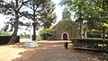
Saint-Michel chapel
_002.JPG)
_006.JPG)
literature
- Le Patrimoine des Communes de la Loire-Atlantique . Flohic Editions, Volume 1, Charenton-le-Pont 1999, ISBN 2-84234-040-X , pp. 97-98.