Macon County, Missouri
![The Macon County Courthouse in Macon, listed on NRHP No. 78001668 [1]](https://upload.wikimedia.org/wikipedia/commons/thumb/1/15/MACON_COUNTY_COURTHOUSE_AND_ANNEX.jpg/298px-MACON_COUNTY_COURTHOUSE_AND_ANNEX.jpg) The Macon County Courthouse in Macon, listed on NRHP No. 78001668 |
|
| administration | |
|---|---|
| US state : | Missouri |
| Administrative headquarters : | Macon |
| Address of the administrative headquarters: |
County Courthouse P.O. Box 96 Macon, MO 63552-0096 |
| Foundation : | 1837 |
| Area code : | 001 660 |
| Demographics | |
| Residents : | 15,566 (2010) |
| Population density : | 7.5 inhabitants / km 2 |
| geography | |
| Total area : | 2104 km² |
| Water surface : | 23 km² |
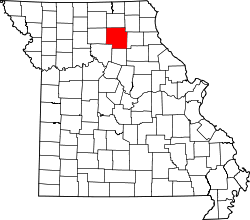
| map | |
| Website : maconcountymo.com | |
The Macon County is a county in the US -amerikanischen State Missouri . In 2010 , the county had 15,566 residents and a population density of 7.5 people per square kilometer. The county seat is Macon .
geography
The county is located in north central Missouri. It has an area of 2104 square kilometers, of which 23 square kilometers are water. The following neighboring counties border Macon County:
| Adair County | Knox County | |
| Linn County |

|
Shelby County |
| Chariton County | Randolph County |
history
| Population development | |||
|---|---|---|---|
| Census | Residents | ± in% | |
| 1840 | 6034 | - | |
| 1850 | 6565 | 8.8% | |
| 1860 | 14,346 | 118.5% | |
| 1870 | 23,230 | 61.9% | |
| 1880 | 26,222 | 12.9% | |
| 1890 | 30,575 | 16.6% | |
| 1900 | 33,018 | 8th % | |
| 1910 | 30,868 | -6.5% | |
| 1920 | 27,518 | -10.9% | |
| 1930 | 23,070 | -16.2% | |
| 1940 | 21,396 | -7.3% | |
| 1950 | 18,332 | -14.3% | |
| 1960 | 16,473 | -10.1% | |
| 1970 | 15,432 | -6.3% | |
| 1980 | 16,313 | 5.7% | |
| 1990 | 15,345 | -5.9% | |
| 2000 | 15,762 | 2.7% | |
| 2010 | 15,566 | -1.2% | |
| Before 1900 1900–1990 2000 2010 | |||
Macon County was formed in 1837. Like the city of Macon, it was named after Nathaniel Macon , a member of the United States Congress and a US Senator from North Carolina .
Demographic data
As of the 2010 census , Macon County had 15,566 people in 6,348 households. The population density was 7.5 inhabitants per square kilometer. Statistically, 2.34 persons lived in each of the 6348 households.
The racial the population was composed of 95.2 percent white, 2.5 percent African American, 0.3 percent Native American, 0.5 percent Asian and other ethnic groups; 1.6 percent were descended from two or more races. Hispanic or Latino of any race was 1.0 percent of the population.
23.7 percent of the population were under 18 years old, 56.0 percent were between 18 and 64 and 20.3 percent were 65 years or older. 51.0 percent of the population was female.
The median income for a household was 36,429 USD . The per capita income was $ 18,411. 14.8 percent of the population lived below the poverty line.
Macon County localities
structure
Macon County is divided into 24 townships :
|
|
|
See also
Individual evidence
- ↑ Extract from the National Register of Historic Places - No. 78001668 Retrieved May 18, 2019
- ↑ GNIS-ID: 758514. Retrieved on February 22, 2011 (English).
- ↑ a b c U.S. Census Bureau, State & County QuickFacts - Macon County, MO ( Memento of the original from July 14, 2011 on WebCite ) Info: The archive link was automatically inserted and not yet checked. Please check the original and archive link according to the instructions and then remove this notice. Retrieved November 5, 2012
- ^ A b National Association of Counties.Retrieved November 5, 2012
- ^ US Census Bureau - Census of Population and Housing.Retrieved March 15, 2011
- ^ Extract from Census.gov.Retrieved February 18, 2011
- ↑ Missouri Census Data Center ( page no longer available , search in web archives ) Info: The link was automatically marked as defective. Please check the link according to the instructions and then remove this notice. Retrieved November 5, 2012
Web links
Coordinates: 39 ° 50 ′ N , 92 ° 34 ′ W

