
Niederweiler (Eifel)
| coat of arms | Germany map | |
|---|---|---|

|
Coordinates: 50 ° 2 ′ N , 6 ° 27 ′ E |
|
| Basic data | ||
| State : | Rhineland-Palatinate | |
| County : | Eifel district Bitburg-Prüm | |
| Association municipality : | Bitburger Land | |
| Height : | 397 m above sea level NHN | |
| Area : | 4.58 km 2 | |
| Residents: | 90 (Dec. 31, 2019) | |
| Population density : | 20 inhabitants per km 2 | |
| Postal code : | 54636 | |
| Area code : | 06569 | |
| License plate : | BIT, PRÜ | |
| Community key : | 07 2 32 092 | |
| Association administration address: | Hubert-Prim-Strasse 7 54634 Bitburg |
|
| Website : | ||
| Mayoress : | Sandra Lempges | |
| Location of the local community Niederweiler in the Eifelkreis Bitburg-Prüm | ||
  |
||

_01.jpg)
Niederweiler is a municipality in the Eifelkreis Bitburg-Prüm in Rhineland-Palatinate . It belongs to the Verbandsgemeinde Bitburger Land .
geography
Niederweiler is located in the southwest Eifel , approx. 10 km northwest of the district town of Bitburg. The municipality extends on the ridge between Nims and Prüm . The location is 410 m above sea level. NHN , within the entire district, the lowest point on the Prüm is 280 m above sea level. Reached NHN , the highest point is 455 m above sea level. NHN . With 57% the majority of the community area is used for agriculture, 33% is forested. There are also several orchards .
history
Finds from pre-Christian times testify to an early, sedentary settlement of the community area. An urn grave field from around 1000 BC found in the Ringelstein corridor in 1966. BC - probably belonging to the settlement center of Biersdorf-Wiersdorf - indicates the human presence in the Iron Age . From around 600 BC Numerous burial mounds were created, which were found in 1934 "Auf dem Krambusch" and 1964 "bei Ringelstein". The Romans took the Niederweiler area around 50 BC. Chr. For in claim. Remnants from this period were found in several places in what is now the municipality. The Franks also left 600–700 remains in Niederweiler.
The place was first mentioned in a document in 1257. Back then bequeathed Ritter Diffried of Hamm the monastery Himmerod half of his estate to "Wilre" in "Ham". At that time, the name of the place still referred to the now separate municipalities of Oberweiler and Niederweiler combined. The parish church of Biersdorf had five branches in 1330, including in Niederweiler and Oberweiler.
From around 1000 Niederweiler belonged to the Geckler dairy in the Luxembourg county of Vianden .
The mayor of Biersdorf administered the place from 1816 and in 1856 went to the mayor of Bickendorf , renamed in 1927 to "Amt Bickendorf". This in turn was merged with other offices in the course of the Rhineland-Palatinate functional and territorial reform in 1970 to form the Verbandsgemeinde Bitburg-Land, which has since been responsible for the administration of the local community Niederweiler. Niederweiler has been part of the new Bitburger Land association since July 1, 2014 .
- Population development
The development of the population of Niederweiler; the values from 1871 to 1987 are based on censuses:
|
|
politics
Municipal council
The municipal council in Niederweiler consists of six council members, who were elected by a majority vote in the local elections on May 26, 2019 , and the honorary local mayor as chairman.
coat of arms
|
|
|
| Justification of the coat of arms: The red coat of arms with a silver bar indicates that it has belonged to the County of Vianden for centuries . The two burning candles are the attribute of the church patron, St. Blaise . |
Culture and sights
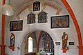
- The town's landmark is the well-preserved branch church of St. Blasius, built around 1700 . In 1738 the stone altar, which has been restored as an exemplary model, was built. The panels of the fourteen emergency helpers and two niche crosses from around 1600 and 1620 are attached to the church, which also make the building known regionally.

St. Blaise
Fourteen emergency panels

Four helpers

Column Altar (1738)

High altar, St. Eustachius

Chapel room
_01.jpg)
_14.jpg)
_15.jpg)
_04.jpg)
_05.jpg)
_11.jpg)
- The Merkeshausen hunting lodge is located nearby. The castle was built in 1893 with administrative and farm buildings. In 1933 the property was sold to the Bitburger brewery . During the Second World War the castle was destroyed and later replaced by a new building. The preserved forester's lodge from Merkeshausen Castle still stands here . ⊙
See also: List of cultural monuments in Niederweiler
Green spaces and recreation
- Hiking routes in and around Niederweiler
- Natural monuments ash and silver maple at the Merkeshausen forest estate
See also: List of natural monuments in Niederweiler
Regular events
- Annual fair or parish fair .
- Traditional rattling or rattling on Good Friday and Holy Saturday
- Hut burning on the first weekend after Ash Wednesday (so-called Scheef Sunday)
Public facilities
The former school building is now used as a village community center. The community is also the location of a volunteer fire brigade .
literature
- Ernst Wackenroder (arr.): The art monuments of the Bitburg district (= Paul Clemen [Hrsg.]: The art monuments of the Rhine province . Volume 12 / I ). Trier 1983, ISBN 3-88915-006-3 , p. 43–44 (315 p., With 12 plates and 227 illustrations in the text. Reprinted by the Schwann edition, Düsseldorf 1927).
Web links
- Local community Niederweiler on the website of the Verbandsgemeinde Bitburger Land
- To search for cultural assets of the local community Niederweiler (Eifel) in the database of cultural assets in the Trier region .
Individual evidence
- ↑ State Statistical Office of Rhineland-Palatinate - population status 2019, districts, communities, association communities ( help on this ).
- ↑ State Statistical Office Rhineland-Palatinate (ed.): Official directory of the municipalities and parts of the municipality. Status: January 2019 [ Version 2020 is available. ] . S. 108 (PDF; 3 MB).
- ↑ a b State Statistical Office Rhineland-Palatinate: Regional data.
- ^ The Regional Returning Officer Rhineland-Palatinate: Municipal elections 2014, city and municipal council elections
- ↑ Niederweiler coat of arms
- ^ Entry on the Merkeshausen hunting lodge in the database of cultural assets in the Trier region ; accessed on February 15, 2018.
- ↑ Entry on Merkeshausen Castle in the private database "Alle Burgen". Retrieved February 15, 2018.
- ↑ To Merkeshausen Castle in the Prümtal. Retrieved February 4, 2018 .
- ^ Hut burning in Niederweiler. Retrieved February 4, 2018 .
- ↑ Hüttenbrennen in the Eifel. Retrieved May 1, 2016 .
- ↑ Hut Sunday in the Eifel. Retrieved August 10, 2017 .
Bath | Balesfeld | Baustert | Bettingen | Bickendorf | Biersdorf am See | Birtlingen | Brecht | Brimingen | Burbach | Dahlem | Dockendorf | Dudeldorf | Echtershausen | Ehlenz | Enzen | Esslingen | Etteldorf | Feilsdorf | Flowem | Gindorf | Gondorf | Gransdorf | Halsdorf | Hamm | Heilenbach | Hütterscheid | Hüttingen an der Kyll | Idenheim | Idesheim | Ingendorf | Kyllburg | Kyllburgweiler | Ließem | Malberg | Malberg soft | Meckel | Messerich | Metterich | Mülbach | Nattenheim | Neidenbach | Neuheilenbach | Niederstedem | Niederweiler | Oberkail | Oberstedem | Oberweiler | Oberweis | Olsdorf | Orsfeld | Pickleneem | Rittersdorf | Röhl | Saint Thomas | Sharply cheap | Schleid | Seffern | Seffer soft | Field of being | Steinborn | Stockem | Sülm | Trimport | Usch | Wettlingen | Wiersdorf | Wilsecker | Wissmannsdorf | Wolsfeld | Zendscheid