
Gumperda
| coat of arms | Germany map | |
|---|---|---|

|
Coordinates: 50 ° 49 ' N , 11 ° 31' E |
|
| Basic data | ||
| State : | Thuringia | |
| County : | Saale-Holzland district | |
| Management Community : | Southern Saale Valley | |
| Height : | 216 m above sea level NHN | |
| Area : | 6.27 km 2 | |
| Residents: | 379 (Dec. 31, 2019) | |
| Population density : | 60 inhabitants per km 2 | |
| Postal code : | 07768 | |
| Area code : | 036422 | |
| License plate : | SHK, EIS, SRO | |
| Community key : | 16 0 74 034 | |
| Association administration address: | Bahnhofstrasse 23 07768 Kahla |
|
| Website : | ||
| Mayor : | Holger Schmidt | |
| Location of the municipality of Gumperda in the Saale-Holzland district | ||
  |
||

Gumperda is a municipality in the south of the Saale-Holzland district in Thuringia and part of the administrative community of the southern Saale valley . The community consists of the districts Gumperda and Röttelmisch .
geography
Gumperda is located five kilometers west of Kahla in Reinstädter Grund , on the Thuringian Porcelain Route and is traversed by the Reinstädter Bach . Gumperda is 22 km from Jena.
history

Gumperda was first mentioned on May 18, 876.
The origin of the church is in the 12th century.
Like all of Thuringia, the place was occupied by the US Army in April 1945 and handed over to the Red Army in early July . This made it part of the Soviet Zone and, from 1949, of the GDR . So Gumperda made all the changes associated with it up to German reunification in 1990.
Attractions
Buildings
- The Protestant church of St. Peter and Paul in the center of the village with Romanesque origins was laid out as a fortified church and is probably the oldest church in the Reinstädter Grund. Two tympana in the nave date from the 12th century: the southern relief shows Adam and Eve, the northern (walled up door) flower motifs. The choir tower was increased to its present size around 1500, the nave in the 18th century. Inside there is a high Gothic winged altar with figures of saints, the organ prospectus from 1709 (built by Johann Georg Fincke ) and the Schuke organ from 1982, which was completely overhauled in 2006 .
- A baroque castle , the "Gumperdaer Schloss", was built in 1730 in the town center. Siegfried Schaffner the Elder Ä. set up a "teaching and education institution for boys" in it in 1867. His son Siegfried Schaffner d. J. took over the school in 1877 after the death of his father and developed it further. He built a boarding school for the students, other school buildings, a gym, a sports field and houses for the teachers. In 1926 the country school home, the “Schaffner-Kleemannsche Educational Institution”, was also entitled to the Abitur. In 1946 it was converted into a state central school, later a central auxiliary school and then a home for apprentices. Gumperda Castle has been privately owned since 2012 and is being restored.
Memorial sites
- A plaque on the castle commemorates the founder of the school in this building in 1867, Dr. Siegfried Schaffner the Elder Ä.
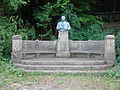
- To the south of the village, at the edge of the forest, there is the “ Pedagogue Cemetery”, created in 1875 as a cemetery for the Schaffner family. In front of it is a monument by Wilhelm Jacobi (1917) for Siegfried Schaffner the Elder. J. The names of his pupils who died in World War 1914–1918 are carved into the bench . A chestnut avenue, the “ grove path ” , leads to the monument .
- A communal grave with a memorial stone in the local cemetery commemorates three unknown concentration camp prisoners who lost their lives on a death march from Buchenwald concentration camp in spring 1945.

Tympanum from 12th century over the church door in Gumperda

Gumperda Castle, formerly a school, 2012

Memorial plaque at Gumperda Castle
Siegfried Schaffner Memorial in Gumperda

Memorial plaque for the death march of prisoners of Buchenwald concentration camp in April 1945

Award plaque for the community of Gumperda in GDR times


Personalities
- Basilius Förtsch , Lutheran theologian, hymn poet and collector, from Rosla in Thuringia was pastor in Gumperda from 1612 to 1619
- Siegfried Schaffner the Elder Ä. (* 1826 in Neustadt am Rennsteig ; † 1877 in Gumperda), 1867 founder of the well-known educational establishment in Gumperdaer Schloss
- Otto Schmiedeknecht (* 1847 in Bad Blankenburg ; † 1936 there), was a German entomologist and temporarily taught at the college
- Siegfried Schaffner the Elder J. (* 1854 in Keilhau ; † 1910), from 1877 successor to his father as director of the educational institution in Gumperda, which he successfully expanded
- Heinrich Bergner (* 1865 in Gumperda; † 1918 in Heilingen ), pastor, was an important art historian
- Paul Schachtschabel (1904–1998), soil scientist and professor at the University of Hanover, was born in Gumperda
Individual evidence
- ^ Population of the municipalities from the Thuringian State Office for Statistics ( help on this ).
- ^ Wolfgang Kahl : First mention of Thuringian towns and villages. A manual. 5th, improved and considerably enlarged edition. Rockstuhl, Bad Langensalza 2010, ISBN 978-3-86777-202-0 , p. 106.
Web links
Albersdorf | Altenberga | Bad Klosterlausnitz | Bibra | Bobeck | Bremsnitz | Bucha | Bürgel | Crossing the Elster | Dornburg-Camburg | Eichenberg | Eineborn | Eisenberg | Frauenprießnitz | Outdoor orla | Geisenhain | Gneus | Golmsdorf | Gosen | Graitschen at Bürgel | Greater buckedra | Grosseutersdorf | Großlöbichau | Großpürschütz | Gumperda | Hainichen | Hainspitz | Hartmannsdorf | Heathland | Hermsdorf | Hummelshain | Jenalöbnitz | Kahla | Karlsdorf | Little buckedra | Kleinebersdorf | Kleineutersdorf | Laasdorf | Lehesten | Lindig | Lippersdorf-Erdmannsdorf | Löberschütz | Mertendorf | Meusebach | Milda | Möckern | Mörsdorf | Nausnitz | Neuengönna | Oberbodnitz | Orlamünde | Ottendorf | Petersberg | Poxdorf | Rattelsdorf | Rauda | Rauschwitz | Rausdorf | Reichenbach | Reinstädt | Renthendorf | Rothenstein | Ruttersdorf-Lotschen | Scheiditz | Schkölen | Grinding trips | Schlöben | Schöngleina | Schöps | Side rod | Serba | Silbitz | Stadtroda | St. Gangloff | Sulza | Tautenburg | Tautendorf | Tautenhain | Animal snail | Tissa | Trobnitz | Trockenborn-Wolfersdorf | Unterbodnitz | Waldeck | Walpernhain | Waltersdorf | Weissbach | Weißenborn | Wichmar | Rooms | Zollnitz