Spich (Lindlar)
|
Speak
municipality Lindlar
Coordinates: 51 ° 1 ′ 58 ″ N , 7 ° 19 ′ 48 ″ E
|
||
|---|---|---|
| Height : | 208 m above sea level NN | |
| Residents : | 18th | |
| Postal code : | 51789 | |
| Area code : | 02266 | |
|
Location of Spich in Lindlar |
||
|
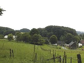
View of the town of Spich
|
||
The hamlet of Spich is part of the municipality of Lindlar , Oberbergischer Kreis in the administrative district of Cologne in North Rhine-Westphalia ( Germany ).
Location and description
Spich is located in the northwest of the municipality of Lindlar between Kaufmannsommer and Frangenberg bei Linde . To the north of Spich, the Miebesberg rises to a height of 250 m.
history
In 1534 the place was documented for the first time, namely "Brotherhood Book of the Marienbruderschaft". Spelling of the first mention: Spycher .
In 1830 Spich had 27 residents.
Attractions
- Footfall from 1786
- Road cross from 1817
freetime and sports
The Linder sports field is located south of Spich, near Frangenberg .
Hiking and biking trails
- The A2 circular hiking trail (Linde - Frangenberg - Spich - Kurtenbach - Kaufmannsommer - Rölenommer - Müllersommer - Linde) runs through the village
bus connections
School bus stop Spich :
- Z51 Unterbreidenbach - Oberbreidenbach - Spich- Frangenberg - Linde-Bruch (school bus shuttle)
Next stop Linde :
- VRS ( OVAG ) line 335 Scheel - Frielingsdorf - Lindlar - Linde - Biesfeld - Bergisch Gladbach
- VRS ( KWS ) line 402 Unterschbach - Hohkeppel - Lindlar - Linde - Kürten school center (only school traffic)
Individual evidence
- ^ Klaus Pampus: First documentary naming of Oberbergischer places (= contributions to Oberbergischen history. Sonderbd. 1). Oberbergische Department 1924 eV of the Bergisches Geschichtsverein, Gummersbach 1998, ISBN 3-88265-206-3 .


