Saint Malo
|
Saint-Malo Sant-Maloù |
||
|---|---|---|

|
|
|
| region | Brittany | |
| Department | Ille-et-Vilaine | |
| Arrondissement | Saint-Malo ( sub-prefecture ) | |
| Canton | Saint-Malo-1 , Saint-Malo-2 | |
| Community association | Pays de Saint-Malo | |
| Coordinates | 48 ° 39 ′ N , 2 ° 1 ′ W | |
| height | 0-51 m | |
| surface | 36.58 km 2 | |
| Residents | 46,097 (January 1, 2017) | |
| Population density | 1,260 inhabitants / km 2 | |
| Post Code | 35400 | |
| INSEE code | 35288 | |
| Website | http://www.ville-saint-malo.fr/ | |
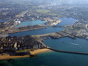
 Old town (left) and port facilities of Saint-Malo |
||
Saint-Malo ( Breton Sant-Maloù ; gallo Saent-Malô ) is a town with 46,097 inhabitants (as of January 1, 2017) in Brittany in north-western France in the Ille-et-Vilaine department . The city is the most important port on the north coast of Brittany and one of the most popular tourist destinations in France due to its historic town center and fortifications.
geography
Saint-Malo is located on the Côte d'Émeraude (German: Smaragd Coast) in northern Brittany at the mouth of the Rance River opposite the seaside resort of Dinard . The historic city center intra muros (within the city walls) makes up about 20% of the total area of the city and is washed by water from three sides.
tide
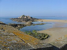
In the bay of Saint-Malo there is one of the largest tidal differences in Europe: there is a difference of up to twelve meters between low tide and high tide. Three of the offshore islands Grand Bé and Petit Bé as well as the Fort National (fortress built by Vauban in 1689) can therefore be reached on foot at low tide. The Usine marémotrice de la Rance has been located in the Rance estuary since 1966, the world's first and, until 2011, largest tidal power plant in the world.
climate
| Saint Malo | ||||||||||||||||||||||||||||||||||||||||||||||||
|---|---|---|---|---|---|---|---|---|---|---|---|---|---|---|---|---|---|---|---|---|---|---|---|---|---|---|---|---|---|---|---|---|---|---|---|---|---|---|---|---|---|---|---|---|---|---|---|---|
| Climate diagram | ||||||||||||||||||||||||||||||||||||||||||||||||
| ||||||||||||||||||||||||||||||||||||||||||||||||
|
Average monthly temperatures and rainfall for Saint-Malo
Source: [2] ;
|
|||||||||||||||||||||||||||||||||||||||||||||||||||||||||||||||||||||||||||||||||||||||||||||||||||||||||
coat of arms
Description : In red below a golden braided lattice and above a silver running ermine with a fleeing cloth on the golden collar.
history
The origin of the city was the Gallo-Roman settlement of Aleth , which was located on a peninsula in front of today's St. Servan district . For a long time, the strategically favorable location protected the residents from intruders. In the 6th century the Welsh monk Machutus , also called Maclou or Maclovius , whose name became Malo in French , began proselytizing the inhabitants. Gradually the settlement began to grow and expand to the neighboring mainland. The patron saint and thus namesake of the new district was Saint Servan.
In the 12th century the pressure on the settlement increased due to attacks by the Normans. The island to the north, today Intra muros , seemed to offer the necessary protection. In 1142 the bishop also settled on the island and built a cathedral (Saint-Vincent) there. In the following years, the construction of a mighty defensive wall began , which gave the city, now called Saint-Malo , security and independence for a long time.
The city reached its heyday in the 16th century. Through fishing and trade (including pirate trips, surreptitious trade and slave trade) Saint-Malo achieved prosperity. A republic of its own was proclaimed in 1590, but it only existed until 1594. This was the basis for the self-confidence of the residents, who called themselves Malouinen (French: malouins ). Saint-Malo was feared by Dutch and English merchant ships, because the city was also home to corsairs , above all Robert Surcouf (1773-1827), who went on a foray with his fast and agile ship “Renard” (fox). He was so successful at this that he was able to retire at the age of 35.
In August 1944, after the Allies landed in Normandy, about 85 percent of the inner city of Saint-Malo ( intra muros ) was destroyed by Anglo-American bombing , as the fortress commander at the time, Colonel Andreas von Aulock , refused to surrender. In contrast to other heavily destroyed cities, Saint-Malo tried to reconstruct it as true to the original as possible, which was largely successful. One relied on old plans and images of the city.
In 1967 the neighboring towns of Saint-Servan and Paramé were incorporated.
Saint Malo today
Today Saint-Malo has about 45,980 inhabitants (as of January 1, 2014) and is not only a tourist destination, but also an important industrial center. However, the industrial companies are all “extra muros”, i.e. outside the (city) walls. In the city's coat of arms there is an ermine that goes over the city gate in a poor coat, as well as the city's motto " semper fidelis " (always faithful). As the inhabitants of Saint-Malo are very proud of their city, their motto is: “Ni Français, ni Breton, Malouin suis” (neither French nor Breton, I am a resident of Saint-Malo).
Population development
| year | 1856 | 1901 | 1962 | 1968 | 1975 | 1982 | 1990 | 1999 | 2007 | 2017 | |
|---|---|---|---|---|---|---|---|---|---|---|---|
| Residents | 10,809 | 11,486 | 17,137 | 42,297 1 | 45.030 | 46,347 | 48.057 | 50,675 | 52,737 | 46.097 | |
| Sources: Cassini and INSEE ; 1 after the merger of Saint-Malo, Saint-Servan and Paramé in 1962 | |||||||||||
Town twinning
Saint-Malo has city partnerships with Port Louis , the capital of the island state of Mauritius , and with Gaspé in Québec , Canada.
traffic
The place is the end of the Rennes – Saint-Malo railway line . Since 2017 he is directly with the TGV to Paris connected. There are 10 city bus routes in the city and there are 9 suburban bus routes, all of which are operated by Keolis.
There are regular ferry connections. a. to Jersey Island ( St Helier ), Guernsey Island ( St Peter Port ) and Portsmouth in Great Britain.
additional
In 1764 the first settlement was founded on the Falkland Islands under French rule by Louis Antoine de Bougainville . The first settlers were sailors and fishermen from Saint-Malo; after these the French name of the archipelago - "Îles Malouines" was created. The Argentine name Islas Malvinas goes back to the French name.
Personalities
- Jacques Cartier (1491–1557), who discovered Canada in 1534.
- René Duguay-Trouin (1673–1736), corsair and privateer
- Nicolas-Charles-Joseph Trublet (1697–1770), member of the Académie française
- Pierre Louis Moreau de Maupertuis (1698–1759), mathematician, astronomer and philosopher
- Bertrand François Mahé de La Bourdonnais (1699–1753), admiral
- Julien Offray de La Mettrie (1709–1751), doctor and philosopher
- Marc-Joseph Marion du Fresne (1724–1772), explorer
- Joseph Quesnel (1746–1809), Canadian composer, writer and actor
- François-René de Chateaubriand (1768–1848), politician and poet. His grave is on the offshore island of Grand Bé .
- François Broussais (1772–1838), medic
- Robert Surcouf (1773–1827), corsair in Napoleon's service.
- Félicité de Lamennais (1782–1854), priest and religious philosopher
- Jean Marie Constant Duhamel (1797–1872), mathematician and physicist
- Martin Fourichon (1809–1884), Admiral and Minister of the Navy
- Alain Cuny (1908–1994), actor
- Alexandre Joly (* 1971), Catholic clergyman, auxiliary bishop in Rennes
- Justine Le Pottier (born 1983), actress
- Broken Back (* 1990), musician
- Manuel Guinard (* 1995), tennis player
See also:
literature
- Le Patrimoine des Communes d'Ille-et-Vilaine. Flohic Editions, Volume 2, Paris 2000, ISBN 2-84234-072-8 , pp. 1513-1569.
Web links
- Saint-Malo information and images
- Keolis Saint-Malo transport company website (French)
Individual evidence
- ↑ Network map of the bus routes , accessed on August 16, 2017


