
Wurzbach
| coat of arms | Germany map | |
|---|---|---|

|
Coordinates: 50 ° 28 ' N , 11 ° 32' E |
|
| Basic data | ||
| State : | Thuringia | |
| County : | Saale-Orla district | |
| Height : | 525 m above sea level NHN | |
| Area : | 72.32 km 2 | |
| Residents: | 3081 (Dec. 31, 2019) | |
| Population density : | 43 inhabitants per km 2 | |
| Postal code : | 07343 | |
| Area code : | 036652 | |
| License plate : | SOK, LBS, PN, SCZ | |
| Community key : | 16 0 75 133 | |
| LOCODE : | DE WZB | |
| City structure: | Core city; 6 districts | |
City administration address : |
Peopleberger Str. 10 07343 Wurzbach |
|
| Website : | ||
| Mayor : | Jan Schübel | |
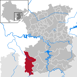
| Location of the city of Wurzbach in the Saale-Orla district | ||
  |
||


Wurzbach is a country town in the Saale-Orla district in Thuringia .
geography
The town of Wurzbach is located on the north-western edge of the Franconian Forest on the Sormitz , is 72.31 km² in size and is located at an altitude of 500 to 725 m above sea level. NN .
City structure
The following districts belong to the city of Wurzbach (first documented mention on June 23, 1250):
- Grumbach (1616),
- Heberndorf (December 17, 1413),
- Heinersdorf (June 23, 1250),
- Oßla (June 23, 1250),
- Titschendorf (1616) and
- Weitisberga (January 18, 1380).
and the Heinrichsort settlement .
history
The place, laid out as a forest hoof village, was first mentioned on June 23, 1250 as the property of the Lords of Lobdeburg . The place belonged to the Reussian rule Ebersdorf , at times the lines Reuss-Lobenstein and Reuss-Ebersdorf . From 1848 to 1918 Wurzbach belonged to the Principality of Reuss younger line . In 1930 Wurzbach was granted city rights. After the FDGB holiday service put the Frankenwald home into operation in 1984, Wurzbach became a place of relaxation for the working people. There were daily events such as guided hikes, color slide presentations, music events, magic and dance evenings and trips to the surrounding area.
Technology history
In the 15th century the handicraft of the hammer forge was already mentioned, and it is therefore the oldest in the place. Plate and spoon makers were added in the 16th century, and the steelworks in Benignengrün and Solmsgrün were established. The Heinrichshütte (originally owned by the Meier and Kämmerer families, expropriated) was founded in 1729 and has been preserved as a technical monument.
Today, tourists can visit the largest steam engine of its type in Europe in the Technical Show Monument and take part in the casting show.
Political history
During the Second World War , 18 workers from the occupied countries of Eastern Europe had to do forced labor . A forced laborer from Poland was executed for " self-mutilation " in 1943 in the Brandenburg-Görden prison.
Incorporations
On July 1, 1999, the previously independent communities of Grumbach, Heberndorf, Heinersdorf, Oßla, Titschendorf and Weitisberga as well as the previous town of Wurzbach (old community key 16 0 75 126), which formed the administrative community for the Wurzbach region , were dissolved and incorporated into the town of Wurzbach.
Population development
Development of the population (from 1994 as of December 31st):
|
|
|
|
|
- Data source from 1994: Thuringian State Office for Statistics
politics
City council
The local elections on May 25, 2014 resulted in the following distribution of seats for the 2014–2019 legislative period :
| Party / list | Seats |
| CDU - Citizens' Union | 7th |
| The left | 3 |
| Club voter community | 6th |
coat of arms
Blazon : "In silver on a green mountain a striding golden crane."
Culture and sights
art

The Leipzig artist Michael Fischer-Art redesigned the old transformer tower on the market. The initiative came from Bärbel Müller, who runs a gallery on the market right next to the tower. The project was financed by donations. The work of art was inaugurated in August 2008.
church
Museums
- The Heinrichshütte technical museum provides information on the development of foundry technology. One of the largest preserved steam engines in Europe is a special attraction .
- As a technical monument, the Zschachenmühle Museum shows the history of agricultural technology in the region. It also has a mineral collection, an art and sculpture park with some bizarre junk figures and a "garden of paradise".
Memorials
Since 1985, a stele on the outskirts of the village in the direction of Lobenstein has been commemorating the death march of concentration camp prisoners from the Laura subcamp near Lehesten in spring 1945.
Tourism and leisure
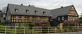
The old town hall on the market (WurzBachHaus) is an old family property and is still inhabited today. Individual rooms are used as a nature park information point. Just a few meters away, boards provide information about the city's history. The 320 m long ski lift with downhill, cross-country skiing and tobogganing options is located near the family hotel Aparthotel Am Rennsteig. Wurzbach also has a cinema and a library. In the neighboring Franconian Forest there are around 120 km of signposted hiking trails.

Residential houses
"An der Sormitz"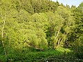
city Park
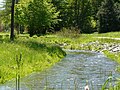
Sormitz in the city park
The WurzBachHaus

Church and building,
clad with slate
Garden shed

Aparthotel Wurzbach
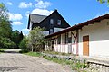
railway station


.JPG)
Personalities
- Fritz Spindler (1816–1905), pianist and composer
- Knut Herschel (1948–1999), grandmaster in correspondence chess
traffic
The station Wurzbach (Thür) is located on the railway line Hockeroda-Unterlemnitz . The station is a hairpin .
Web links
Individual evidence
- ^ Population of the municipalities from the Thuringian State Office for Statistics ( help on this ).
- ^ Wolfgang Kahl : First mention of Thuringian towns and villages. A manual. Volume 5, improved and significantly expanded edition. Rockstuhl Verlag, Bad Langensalza 2010, ISBN 978-3-86777-202-0 , pp. 321, 104, 114, 116, 214, 286, 309.
- ^ Johann Ernst Fabri : Geography for all estates. Part 1, Volume 4: Which contains the continuation and the resolution of the Upper Saxon Circle. Schwickert Verlag, Leipzig 1793, p. 882 .
- ↑ Thuringian Association of the Persecuted of the Nazi Regime - Association of Antifascists and Study Group of German Resistance 1933–1945 (Ed.): Local history guide to sites of resistance and persecution 1933–1945. Volume 8: Thuringia. VAS - Verlag für Akademische Schriften, Frankfurt am Main 2003, ISBN 3-88864-343-0 , p. 230.
- ↑ StBA: Changes in the municipalities in Germany, see 1999
- ^ Thuringian State Office for Statistics, 2014 municipal council elections in Thuringia - final result for Wurzbach.
- ↑ Hartmut Ulle: New Thuringian Wappenbuch. Volume 2: Ilmkreis, Jena, Kyffhäuserkreis, Saale-Orla-Kreis, Saalfeld-Rudolstadt (district), Schmalkalden-Meiningen (district), Suhl. 2nd, changed, revised edition. Working group Genealogy Thuringia, Erfurt 1997, ISBN 3-9804487-2-X , p. 48.
- ^ Collection of newspaper reports from the OTZ. ( Memento of November 10, 2010 in the Internet Archive ) Retrieved January 16, 2011.
Dürrenbach | Grumbach | Haslersberg | Heberndorf | Heinersdorf | Heinrichshöhe | Heinrichsort | Velcro hammer | Knauermühle | Oßla | Rodacherbrunn | Titschendorf | Weitisberga | Wurzbach
Bad Lobenstein | Bodelwitz | Dittersdorf | Döbritz | Dreitzsch | Eßbach | Gefell | Geroda | Gertewitz | Görkwitz | Göschitz | Gössitz | Grobengereuth | Hirschberg | Keila | Cherry chew | Kospoda | Krölpa | Langenorla | Lausnitz | Lemnitz | Löhma | Miesitz | Mittelpöllnitz | Moßbach | Moxa | Neundorf (near Schleiz) | Neustadt an der Orla | Nimritz | Oberoppurg | Oettersdorf | Oppurg | Paska | Peuschen | Plot | Pörmitz | Pößneck | Quaschwitz | Ranis | Remptendorf | Rosendorf | Rosenthal am Rennsteig | Saalburg-Ebersdorf | Schleiz | Lubricating seat | Schmorda | Schondorf | Seisla | Solkwitz | Tanna | Tegau | Tommelsdorf | Triptis | Volkmannsdorf | Weira | Wernburg | Wilhelmsdorf | Wurzbach | Ziegenrück