Chouvigny
| Chouvigny | ||
|---|---|---|

|
|
|
| region | Auvergne-Rhône-Alpes | |
| Department | Allier | |
| Arrondissement | Vichy | |
| Canton | Gannat | |
| Community association | Saint-Pourçain Sioule Limagne | |
| Coordinates | 46 ° 8 ′ N , 2 ° 59 ′ E | |
| height | 310-584 m | |
| surface | 13.41 km 2 | |
| Residents | 227 (January 1, 2017) | |
| Population density | 17 inhabitants / km 2 | |
| Post Code | 03450 | |
| INSEE code | 03078 | |
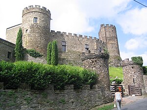
 Château de Chouvigny |
||
Chouvigny is a French one community with 227 inhabitants (at January 1, 2017) in the department Allierin the region Auvergne Rhône-Alpes . It belongs to the arrondissement of Vichy and the canton of Gannat .
geography
The municipality is located on the Sioule , about 35 kilometers west of Vichy . The municipality of Chouvigny borders the Puy-de-Dôme department in the south .
Population development
| year | 1962 | 1968 | 1975 | 1982 | 1990 | 1999 | 2006 |
| Residents | 340 | 349 | 265 | 255 | 240 | 238 | 239 |
Attractions
See also: List of Monuments historiques in Chouvigny
- Château, built in the middle of the 13th century 80 m on a rock above the gorges of the Sioule (Gorges de la Sioule), bought and restored by the Duke of Morny in the middle of the 19th century
- Saint Pierre church, built in 1760, with statues "Notre Dame de Chouvigny" and "Saint Roch" (18th century)
- La table de Péraclos (rock formation)
literature
- Le Patrimoine des Communes de l'Allier. Flohic Editions, Volume 1, Paris 1999, ISBN 2-84234-053-1 , pp. 293-295.
Web links
Commons : Chouvigny - collection of images, videos and audio files
