
Sanssat
| Sanssat | ||
|---|---|---|
|
||
| region | Auvergne-Rhône-Alpes | |
| Department | Allier | |
| Arrondissement | Vichy | |
| Canton | Saint-Pourçain-sur-Sioule | |
| Community association | Entr'Allier Besbre et Loire | |
| Coordinates | 46 ° 15 ′ N , 3 ° 29 ′ E | |
| height | 249-367 m | |
| surface | 8.4 km 2 | |
| Residents | 259 (January 1, 2017) | |
| Population density | 31 inhabitants / km 2 | |
| Post Code | 03150 | |
| INSEE code | 03266 | |
| Website | http://sanssat.interco-abl.fr/ | |
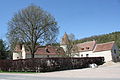
 Town hall (Mairie) of Sanssat |
||

Sanssat is a French municipality with 259 inhabitants (at January 1, 2017) in the department of Allier in the region Auvergne Rhône-Alpes (before 2016 Auvergne ). It belongs to the arrondissement of Vichy and the canton of Saint-Pourçain-sur-Sioule (until 2015 Varennes-sur-Allier ).
geography
Sanssat is about sixteen kilometers north-northeast of Vichy . Sanssat is surrounded by the neighboring communities of Langy in the north, Saint-Gérand-le-Puy in the east, Saint-Félix in the south, Billy in the southwest and Créchy in the west and northwest.
Population development
| year | 1962 | 1968 | 1975 | 1982 | 1990 | 1999 | 2006 | 2011 | 2016 |
| Residents | 313 | 328 | 309 | 280 | 287 | 277 | 282 | 257 | 271 |
| Source: Cassini and INSEE | |||||||||
Attractions
- Saint-Cyr-Sainte-Julitte church from the 19th century
- Rectory
- Saint-Alyre Castle
- Theillat Castle from the 19th century
- 15th century mansion Les Granges

Saint-Cyr-et-Sainte-Julitte church

Saint-Alyre Castle

Theillat Castle
Les Granges manor house
_2016-09-03.JPG)


literature
- Le Patrimoine des Communes de l'Allier . tape 2 . Flohic Editions, Paris 1999, ISBN 2-84234-053-1 , pp. 1054-1057 .
Web links
Commons : Sanssat - collection of images, videos and audio files