Abrest
| Abrest | ||
|---|---|---|

|
|
|
| region | Auvergne-Rhône-Alpes | |
| Department | Allier | |
| Arrondissement | Vichy | |
| Canton | Vichy-2 | |
| Community association | Vichy Community | |
| Coordinates | 46 ° 6 ′ N , 3 ° 27 ′ E | |
| height | 251-434 m | |
| surface | 10.46 km 2 | |
| Residents | 2,931 (January 1, 2017) | |
| Population density | 280 inhabitants / km 2 | |
| Post Code | 03200 | |
| INSEE code | 03001 | |
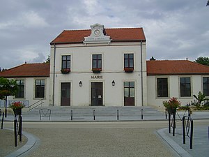
 Mairie Abrest |
||
Abrest is a French commune with 2931 inhabitants (as of January 1, 2017) in the Allier department in the Auvergne-Rhône-Alpes region . It belongs to the arrondissement of Vichy and the canton of Vichy-2 .
geography
The municipality of Abrest is located on the Allier and borders immediately to the south with the city of Vichy . The La Tour district to the left of the Allier has no bridge or ferry connection to the core town on the right side of the river.
Neighboring municipalities to Abrest are Vichy in the north, Le Vernet in the northeast, Busset in the southeast, Saint-Yorre and Hauterive in the south, Brugheas in the west and Bellerive-sur-Allier in the northwest.
Population development
| year | 1962 | 1968 | 1975 | 1982 | 1990 | 1999 | 2007 | 2016 |
| Residents | 1,874 | 2,026 | 2,248 | 2,309 | 2,544 | 2,428 | 2,591 | 2,923 |
Attractions
- originally Gothic church of St. Hilarius ( Église Saint-Hilaire ), reconstructed in the 19th century
- Château de Chaussins , a castle built from the 14th to the 16th centuries, monument historique
- 17th century Château de Quinssat
- Tour médiévale du Maubet , an 8th century tower
- House of the former parish of Diocèse de Clermont , dated to the 16th century
literature
- Le Patrimoine des Communes de l'Allier. Flohic Editions, Volume 1, Paris 1999, ISBN 2-84234-053-1 , pp. 165-167.
Individual evidence
- ↑ Château de Chaussins in the Base Mérimée of the French Ministry of Culture (French)
Web links
Commons : Abrest - collection of images, videos and audio files
- Community presentation (French)

