
Rongères
| Rongères | ||
|---|---|---|
|
||
| region | Auvergne-Rhône-Alpes | |
| Department | Allier | |
| Arrondissement | Vichy | |
| Canton | Saint-Pourçain-sur-Sioule | |
| Community association | Entr'Allier Besbre et Loire | |
| Coordinates | 46 ° 18 ' N , 3 ° 27' E | |
| height | 242-305 m | |
| surface | 8.95 km 2 | |
| Residents | 565 (January 1, 2017) | |
| Population density | 63 inhabitants / km 2 | |
| Post Code | 03150 | |
| INSEE code | 03215 | |
| Website | http://rongeres.interco-abl.fr/ | |

Rongères is a French municipality with 565 inhabitants (at January 1, 2017) in the department of Allier in the region Auvergne Rhône-Alpes (before 2016 Auvergne ). It belongs to the arrondissement of Vichy and the canton of Saint-Pourçain-sur-Sioule (until 2015 Varennes-sur-Allier ).
geography
Rongères is about 26 kilometers north-northeast of Vichy . Rongères is surrounded by the neighboring communities of Montoldre in the north, Boucé in the east and northeast, Langy in the south and southeast, Créchy in the southwest and Varennes-sur-Allier in the west and northwest.
The National Route 7 runs through the municipality .
Population development
| year | 1962 | 1968 | 1975 | 1982 | 1990 | 1999 | 2006 | 2011 | 2016 |
| Residents | 465 | 444 | 430 | 509 | 570 | 566 | 537 | 585 | 568 |
| Source: Cassini and INSEE | |||||||||
Attractions
See also: List of the Monuments historiques in Rongères
- Sainte-Marie-Marguerite Church
- Le Méage Castle

Sainte-Marie-Madeleine church
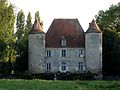
Castle Méage
.jpg)

literature
- Le Patrimoine des Communes de l'Allier . tape 2 . Flohic Editions, Paris 1999, ISBN 2-84234-053-1 , pp. 1037-1040 .
Web links
Commons : Rongères - Collection of images, videos and audio files