
Saint-Prix (Allier)
| Saint Prix | ||
|---|---|---|
|
||
| region | Auvergne-Rhône-Alpes | |
| Department | Allier | |
| Arrondissement | Vichy | |
| Canton | Lapalisse | |
| Community association | Pays de Lapalisse | |
| Coordinates | 46 ° 14 ' N , 3 ° 39' E | |
| height | 279-386 m | |
| surface | 21.75 km 2 | |
| Residents | 796 (January 1, 2017) | |
| Population density | 37 inhabitants / km 2 | |
| Post Code | 03120 | |
| INSEE code | 03257 | |
.JPG) Town hall (Mairie) of Saint-Prix |
||

Saint-Prix is a French municipality with 796 inhabitants (as of January 1 2017) in the department of Allier in the region Auvergne Rhône-Alpes ; it belongs to the arrondissement of Vichy and the canton of Lapalisse .
geography
Saint-Prix is located in the western foothills of the Monts de la Madeleine mountains, around 19 kilometers northeast of Vichy and 31 kilometers northwest of Roanne . Neighboring municipalities of Saint-Prix are Lapalisse in the north and west, Barrais-Bussolles in the north-east, Droiturier in the east, Le Breuil in the south and south-east and Saint-Christophe and Billezois in the south-west.
The National Route 7 runs through the municipality .
The Lapalisse-Saint-Prix station on the Moret-Veneux-les-Sablons-Lyon-Perrache railway line , in the municipality of Saint-Prix, is no longer served.
Population development
| year | 1962 | 1968 | 1975 | 1982 | 1990 | 1999 | 2006 | 2001 | 2016 |
| Residents | 825 | 830 | 797 | 837 | 840 | 809 | 806 | 786 | 789 |
| Source: Cassini and INSEE | |||||||||
Attractions
- Saint-Priest church from the 19th century
- Notre-Dame-de-Beaulieu chapel
- La Palice Castle, monument historique since 1998

Saint-Priest church
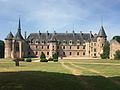
La Palice Castle
.JPG)

literature
- Le Patrimoine des Communes de l'Allier. Flohic Editions, Volume 1, Paris 1999, ISBN 2-84234-053-1 , pp. 561-562.