
Escurolles
|
Escurolles Escuròlas |
||
|---|---|---|
.svg)
|
|
|
| region | Auvergne-Rhône-Alpes | |
| Department | Allier | |
| Arrondissement | Vichy | |
| Canton | Bellerive-sur-Allier | |
| Community association | Saint-Pourçain Sioule Limagne | |
| Coordinates | 46 ° 9 ' N , 3 ° 16' E | |
| height | 287-323 m | |
| surface | 13.27 km 2 | |
| Residents | 775 (January 1, 2017) | |
| Population density | 58 inhabitants / km 2 | |
| Post Code | 03110 | |
| INSEE code | 03109 | |

Escurolles ( Occitan : Escuròlas ) is a French municipality with 775 inhabitants (as of January 1 2017) in the department of Allier in the region Auvergne Rhône-Alpes . It is assigned to the canton of Bellerive-sur-Allier (until March 2015: canton of Escurolles ) and the arrondissement of Vichy .
geography
Escurolles is located 13 kilometers west-northwest of Vichy in the Limagne Bourbonnaise region on the Andelot . Escurolles is surrounded by the neighboring municipalities of Broût-Vernet in the north, Saint-Pont in the east and northeast, Espinannes-Vozelle in the east and southeast, Cognat-Lyonne in the south and southeast, Monteignet-sur-l'Andelot in the south, Saulzet in the west as well Le Mayet-d'École in the northwest.
Population development
| year | 1936 | 1946 | 1954 | 1962 | 1968 | 1975 | 1982 | 1990 | 1999 | 2006 | 2013 |
|---|---|---|---|---|---|---|---|---|---|---|---|
| Residents | 731 | 694 | 623 | 602 | 623 | 617 | 662 | 668 | 657 | 715 | 754 |
| Source: Cassini and INSEE | |||||||||||
Attractions
See also: List of Monuments historiques in Escurolles
- Notre-Dame Benedictine Priory
- Romanesque church of Saint-Cyr-Sainte-Julitte, Monument historique
- Les Granges castle from the 15th century, monument historique since 1983
- Escurolles Castle from the 15th century, a historic monument since 1980
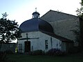
Notre-Dame church

Saint-Cyr-Sainte-Julitte church


literature
- Le Patrimoine des Communes de l'Allier. Flohic Editions, Volume 1, Paris 1999, ISBN 2-84234-053-1 , pp. 354-355.