
Cindré
| Cindré | ||
|---|---|---|
|
||
| region | Auvergne-Rhône-Alpes | |
| Department | Allier | |
| Arrondissement | Vichy | |
| Canton | Moulins-2 | |
| Community association | Entr'Allier Besbre et Loire | |
| Coordinates | 46 ° 20 ′ N , 3 ° 34 ′ E | |
| height | 254-342 m | |
| surface | 22.63 km 2 | |
| Residents | 301 (January 1, 2017) | |
| Population density | 13 inhabitants / km 2 | |
| Post Code | 03220 | |
| INSEE code | 03079 | |
| Website | http://cindre.interco-abl.fr/ | |
 Town hall (Mairie) of Cindré |
||

Cindré is a French municipality with 301 inhabitants (at January 1, 2017) in Allier in the region Auvergne Rhône-Alpes (before 2016 Auvergne ); it belongs to the arrondissement of Vichy and the canton of Moulins-2 (until 2015 Jaligny-sur-Besbre ).
geography
Cindré is about thirty kilometers south-southeast of Moulins and about 20 kilometers north-northeast of Vichy . Cindré is surrounded by the neighboring communities of Treteau in the north, Chavroches in the northeast, Trézelles in the east, Servilly in the south and southeast, Montaigu-le-Blin in the southwest and Boucé in the west.
Population development
| year | 1962 | 1968 | 1975 | 1982 | 1990 | 1999 | 2006 | 2011 | 2016 |
| Residents | 577 | 532 | 430 | 359 | 313 | 313 | 317 | 327 | 301 |
| Source: Cassini and INSEE | |||||||||
Attractions
See also: List of Monuments historiques in Cindré
- Saint-Pierre-Saint-Martin church
- Puyol Castle, a historic monument since 1925
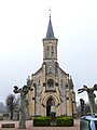
Saint-Pierre-Saint-Martin church

Puyfol Castle


literature
- Le Patrimoine des Communes de l'Allier. Flohic Editions, Volume 1, Paris 1999, ISBN 2-84234-053-1 , pp. 512-513.
Web links
Commons : Cindré - collection of images, videos and audio files