
That
|
That
City of Dortmund
Coordinates: 51 ° 34 ′ 10 ″ N , 7 ° 31 ′ 22 ″ E
|
|
|---|---|
| Height : | approx. 80 m above sea level NHN |
| Area : | 4.03 km² |
| Residents : | 6671 (Dec. 31, 2019) |
| Population density : | 1,654 inhabitants / km² |
| Incorporation : | April 1, 1928 |
| Postal code : | 44329 |
| Area code : | 0231 |
| Statistical District : | 21st |
  Location of Derne in Dortmund
|
|
Derne is the statistical district 21 and at the same time a north-eastern part of the city of Dortmund . On December 31, 2019, 6,671 inhabitants lived in the district belonging to the Scharnhorst district.
geography
The place is about seven kilometers northeast of Dortmund city center and four kilometers south of the city center of the city of Lünen, which is adjacent to Derne . Geographically, the Derner residential development is clearly separated from its neighboring districts. North of the settlement area runs the federal motorway 2 , which is part of the Dortmund motorway ring and today forms the border between Dortmund and Lünen.
Derne was strongly influenced by mining. In particular, the larger eastern part of the town, in which the Derner business center is also located, is largely characterized by colliery houses and smaller multi-family settlements. On the northern outskirts is the Woldemey settlement with up to 12-storey residential high-rises . In recent times, many vacant lots in Derne have been closed, for the most part by building double and terraced houses.
In the smaller western part of the village (Altenderne) there are mostly single and two-family houses. There are also a few half-timbered houses here.
history
The place was originally called Altenderne-Oberbecker . On November 22, 1922, the previously independent municipalities of Altenderne-Niederbecker and Hostedde were incorporated into the municipality of Altenderne-Oberbecker, whose name was changed to Derne on October 27, 1923.
On April 1, 1928, the place was incorporated into the city of Dortmund. However, parts of the community fell to Lünen : today's south of Gahmen used to belong to Niederbecker , and part of Oberbecker has merged into Lünen-Süd .
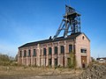
The first drilling began in 1873 with the sinking of the first shaft of the coal mine Gneisenau . The first coal was mined in 1886. In 1985 the colliery was shut down, around 5000 jobs were transferred to other mines or canceled.
Of this shaft system, the headframe II, the shaft from 1883, the shaft IV from 1934 and the machine halls were placed under monument protection. Some typical settlements, such as the Müsersiedlung , have been preserved from the time of prosperous mining . The mine is currently being prepared for the settlement of trade, craft and transport logistics.
On July 1, 1950, there was an exchange of territory between the cities of Dortmund and Lünen. In the Derne area, the motorway was set as the new border. Derne lost about 7.63 hectares to Lünen. This contrasted with a gain of less than one hectare west of the Dortmund – Enschede railway line .
Today there are three parishes in Derne: the Catholic parish, the Evangelical parish and the New Apostolic parish. The non-Christian religious community with the largest number of followers in Derne is Islam.
The district is connected to the rail network via the Dortmund-Derne station .
population
Structure of the Derner population:
- Share of the population under 18-year-olds: 20.4% [Dortmund average: 16.2% (2018)]
- Share of the population of at least 65-year-olds: 18.8% [Dortmund average: 20.2% (2018)]
- Proportion of foreigners: 23.9% [Dortmund average: 18.8% (2019)]
- Unemployment rate: 12.5% [Dortmund average: 11.0% (2017)]
The average income in Derne is around 25% below the Dortmund average. In the west of Dernes (Altenderne) , income is around 10% below the Dortmund average.
Population development
| year | 1987 | 2003 | 2008 | 2013 | 2016 | 2018 |
|---|---|---|---|---|---|---|
| Residents | 6632 | 6492 | 6291 | 6164 | 6545 | 6700 |

Altenderner Strasse

Double-headed headframe of the Gneisenau colliery
Tomsonbock Gneisenau colliery

Luther House Derne


Individual evidence
- ↑ Population figures in the statistical districts on December 31, 2019 (PDF)
- ↑ a b Stephanie Reekers: The regional development of the districts and communities of Westphalia 1817-1967 . Aschendorff, Münster Westfalen 1977, ISBN 3-402-05875-8 , p. 209, 226 .
- ↑ Population share of the under 18 year olds Statistical Atlas 2019 (PDF file)
- ↑ Population share of at least 65-year-olds Statistical Atlas 2019 (PDF file)
- ↑ Nationalities in the statistical districts on December 31, 2019 (PDF file)
- ↑ Unemployment rates according to statistical districts on June 30, 2017 ( memento of the original from June 25, 2018 in the Internet Archive ) Info: The archive link was inserted automatically and has not yet been checked. Please check the original and archive link according to the instructions and then remove this notice. (PDF file)
Web links

Aplerbeck :
Aplerbeck (with Aplerbecker Mark ) |
Berghofen (with Berghofer Mark ) |
Stoke |
Sölde |
Sölderholz (with Lichtendorf )
Brackel :
woodlice |
Brackel (with Neuasseln ) |
Wobble |
Wickede
Eving :
Brechte |
Eving (with Kemminghausen ) |
Holthausen |
Lindenhorst
Hombruch :
Barop (with Schönau ) |
Bitter pulp |
Brünninghausen (with Renninghausen ) |
Eichlinghofen (with spreaders ) |
Hombruch |
Kirchhörde-Löttringhausen (with Großholthausen , Kirchhörde , Kleinholthausen , Löttringhausen and Schanze ) |
Menglinghausen |
Persebeck-Kruckel-Schnee (with Kruckel , Persebeck and Schnee ) |
Rombergpark-Lücklemberg (with Lücklemberg )
Hörde :
Benninghofen (with Loh ) |
Hacheney |
Wood (with highest ) |
Hörde (with Clarenberg ) |
Syburg (with Buchholz ) |
Wellinghofen (with Niederhofen ) |
Wichlinghofen
Huckarde :
Deusen |
Huckarde (with whiskers ) |
Jungferntal cream (with Jungferntal and cream ) |
Kirchlinde (with Hangeney )
city center north :
Borsigplatz |
Port |
Nordmarkt
Innenstadt-Ost :
Kaiserbrunnen (with grains ) |
Ruhrallee |
Westfalendamm (with Gartenstadt ) City Center
West :
City |
Dorstfeld |
Dorstfeld Bridge |
Westfalenhalle (with Kreuzviertel )
Lütgendortmund :
Bövinghausen |
Kley |
Lütgendortmund (with Holte-Kreta and Somborn ) |
Marten |
Oespel |
Westrich (with Dellwig )
Mengede :
Bodelschwingh |
Mengede (with Brüninghausen ) |
Nice |
Oestrich |
Schwieringhausen (with Ellinghausen and Groppenbruch ) |
Westerfilde
Scharnhorst :
Alt-Scharnhorst |
Derne |
Hostedde (with Grevel ) |
Kirchderne |
Kurl-Husen (with Fleier , Husen and Kurl ) |
Lanstrop |
Scharnhorst-Ost