
Dimbach (Palatinate)
| coat of arms | Germany map | |
|---|---|---|

|
Coordinates: 49 ° 10 ' N , 7 ° 54' E |
|
| Basic data | ||
| State : | Rhineland-Palatinate | |
| County : | Southwest Palatinate | |
| Association municipality : | Hauenstein | |
| Height : | 250 m above sea level NHN | |
| Area : | 2.19 km 2 | |
| Residents: | 179 (Dec. 31, 2019) | |
| Population density : | 82 inhabitants per km 2 | |
| Postal code : | 76848 | |
| Area code : | 06392 | |
| License plate : | PS , ZW | |
| Community key : | 07 3 40 006 | |
| Association administration address: | Schulstrasse 4 76846 Hauenstein |
|
| Website : | ||
| Local Mayor : | Thomas Funck | |
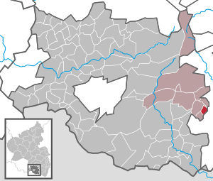
| Location of the local community Dimbach in the district of Südwestpfalz | ||
  |
||


Dimbach is a municipality in the Südwestpfalz district in Rhineland-Palatinate . It belongs to the Verbandsgemeinde Hauenstein , within which it is the smallest local community in terms of population. In addition, it is the fourth smallest in the district of Südwestpfalz.
geography
Dimbach is located in Wasgau , as the southern part of the Palatinate Forest and the adjoining northern part of the Vosges are also called, south of Lug . 74.2% of the district area is forested. Neighboring communities are - clockwise - Schwanheim , Gossersweiler-Stein and Darstein . The 418 meter high Dimberg is located on the boundary of Gossersweiler-Stein and Schwanheim . The place is also part of the southern Palatinate climbing area
history
The first documentary mention took place in 1274 as Dynnebach and was counted as a property of Lindelbrunn Castle . This castle was owned by the Counts of Leiningen . The latter had repeatedly increased need for money and leased Lindelbrunn Castle and the associated properties. So it often happened that the residents of Dimbach had two masters. The Counts of Leiningen and the respective tenant of the castle. At times, the residents therefore had to pay taxes, the tithe , to both gentlemen . The place last belonged to the Prince of Leiningen-Dürkheim until the end of the 18th century.
From 1798 to 1814, when the Palatinate was part of the French Republic (until 1804) and then part of the Napoleonic Empire , Dimbach was incorporated into the canton of Annweiler and was subordinate to the Mairie Oberschlettenbach . In 1815 the place had a total of 170 inhabitants. In 1815 the place Austria was added. Just one year later, Dimbach moved to the Kingdom of Bavaria . From 1818 to 1862 the place was part of the Landkommissariat Bergzabern , which was then converted into a district office.
In 1928 Dimbach had 156 inhabitants who lived in 42 residential buildings. In 1939 the place was incorporated into the Bergzabern district. After the Second World War , Dimbach became part of the then newly formed state of Rhineland-Palatinate within the French occupation zone . In the course of the first Rhineland-Palatinate administrative reform , the place moved in 1969 to the district of Pirmasens (from 1997 district of Südwestpfalz ) . Three years later it was incorporated into the newly created community of Hauenstein .
politics
Municipal council
The municipal council in Dimbach consists of six council members, who were elected by a majority vote in the local elections on May 26, 2019 , and the honorary local mayor as chairman.
mayor
Thomas Funck became the local mayor of Dimbach on July 5, 2014. Since there was no candidate for the direct election on May 26, 2019, the upcoming election of the mayor was carried out by the council in accordance with the municipal regulations. He confirmed Funck on August 1, 2019 for a further five years in his office. Funck's predecessor was Heinz Heft.
coat of arms
|
|
Blazon : "Of silver and red divided by a wavy line, above a green linden tree and below an eight-spoke glaive wheel." |
| Reasons for the coat of arms: The linden tree is taken from the coat of arms of the Lindelbrunn rulership, the Glevenrad from that of the Leininger family. |
partnership
A European community partnership was officially agreed on April 30, 2019 with the market community of the same name Dimbach in Upper Austria in order to further strengthen the friendship that has existed since 2015.
Culture
Buildings
With four residential buildings, a side-by-side house and the Protestant church, there are a total of six properties in Dimbach that are under monument protection .
Events
The Whitsun quack is practiced on site, which is a regional variant of the Whitsun singing.
Infrastructure
Dimbach consists of only six streets. Due to its geographical location, the local community has no through traffic. The county road 53 connects community with lies and Schwanheim. The place is connected to the local transport network via the bus line 525 of the transport association Rhein-Neckar , which leads to Bad Bergzabern and Annweiler am Trifels. There are also weekend houses on site.
Web links
- Local community Dimbach on the website of the association community Hauenstein
- Short portrait of Dimbach on SWR television
- Dimbach - private homepage
- Literature about Dimbach in the Rhineland-Palatinate State Bibliography
Individual evidence
- ↑ State Statistical Office of Rhineland-Palatinate - population status 2019, districts, communities, association communities ( help on this ).
- ↑ daten.digitale-sammlungen.de: List of localities for the Free State of Bavaria . Retrieved July 25, 2018 .
- ^ The Regional Returning Officer Rhineland-Palatinate: Local elections 2019, city and municipal council elections.
- ↑ a b friction over election of councilors. Die Rheinpfalz, August 5, 2014, accessed on April 4, 2020 .
- ↑ The Regional Returning Officer Rhineland-Palatinate: direct elections 2019. Retrieved on April 4, 2020 (see Hauenstein, Verbandsgemeinde, second line of results).
- ↑ Municipal Council. Local community Dimbach (Pfalz), accessed on April 4, 2020 .
- ^ European community partnership with Dimbach in Upper Austria. Local community Dimbach (Pfalz), May 14, 2019, accessed on April 4, 2020 .
- ↑ General Directorate for Cultural Heritage Rhineland-Palatinate (ed.): Informational directory of cultural monuments - District of Südwestpfalz. Mainz 2020, p. 12 f. (PDF; 8.7 MB).

Cities: Dahn | Hornbach | Rodalben
Municipalities: Althornbach | Battweiler | Bechhofen | Biedershausen | Bobenthal | Bottenbach | Bruchweiler-Bärenbach | Bundenthal | Busenberg | Clausen | Contwig | Darstein | Dellfeld | Dietrichingen | Dimbach | Donsieders | Eppenbrunn | Erfweiler | Erlenbach near Dahn | Fischbach near Dahn | Geiselberg | Großbundenbach | Grosssteinhausen | Hauenstein | Heltersberg | Hermersberg | Herschberg | Hettenhausen | Hilst | Hinterweidenthal | Hirschthal | Höheinöd | Höheischweiler | Cave frogs | Horbach | Käshofen | Kleinbundenbach | Kleinsteinhausen | Knopp-Labach | Crows Mountain | Kröppen | Gluing | Lviv | Ludwigswinkel | Lug | Maßweiler | Mauschbach | Merzalben | Münchweiler an der Rodalb | Niederschlettenbach | Nothweiler | Nünschweiler | Obernheim-Kirchenarnbach | Upper sime | Petersberg | Reifenberg | Riedelberg | Rieschweiler-Mühlbach | Rose head | Rumbach | Ruppertsweiler | Saalstadt | Schauerberg | Schindhard | Schmalenberg | Schmitshausen | Schönau | Schwanheim | Schweix | Spirkelbach | Stone albums | Thaleischweiler frogs | Trulben | Vinningen | Waldfischbach castle albums | Wallhalben | Walshausen | Weselberg | Wiesbach | Wilgartswiesen | Winterbach