List of neighborhoods of Istanbul
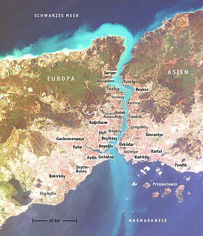
Turkey's largest city , Istanbul , stretches for about 50 kilometers in a west-east and north-south direction and is divided into a European and an Asian side by the Bosporus . The old city center, located in the south of the European side, is also separated from the northern parts of the city by the Golden Horn .
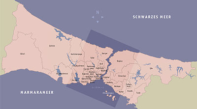
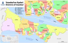
All districts of Istanbul are listed in full, but not all districts.
For pronunciation see Turkish language .
Left in the northeast the Bosphorus towards the Black Sea, in the middle the Golden Horn and the old town, right the west, in the foreground the harbor district.
İlçe
İlçe can be translated as (city) district but also district.
|
|
|||||||||||||||||||||||||||||||||||||||||||||||||||||||||||||||||||||||||||||||||||||||||||||||||||||||||||||||||||||||||||||||||||||||||||||||||||||||||||||||||||||||||||||||||||||||||||||||||||||||||||||||||||||||||||||||||||||||||||||||||||||||||||||||||||||||
European side
Old town
The historic peninsula of Byzantion , Constantinople is located in the south of today's Istanbul on a peninsula between the Sea of Marmara and the Golden Horn (Haliç), which marks the transition from the open sea to the Bosporus (Boğaziçi). It is bounded by the Theodosian Land Wall in the west. The district of Fatih largely corresponds to the historic old town.
Eminonu
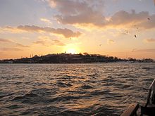
The former municipality of Eminönü is located in the area of the oldest settlement of Byzantion, which dates back to the 7th century BC. Was founded by Megarians from the Peloponnese .
In Eminönü - located at the tip of the peninsula - is the historical center of the city with the former cathedral Hagia Sophia (Ayasofya Müzesi), the nearby church Hagia Irene (Aya İrini Müzesi), the remains of the Byzantine imperial palace (mosaic museum, Mozaik Müzesi), the ancient cisterns ( Yerebatan Sarnıcı ), the hippodrome ( At Meydanı ), the former sultan 's palace ( Topkapı Sarayı ) and important mosques (the “ Blue Mosque ” Sultan Ahmed, the Suleymaniye Mosque , the Rüstem Pasha Mosque and the Beyazıt Mosque , the oldest in town). The oldest city wall surrounds this district.
Other important museums are the Archaeological Museum near Topkapi Palace and the Turkish-Islamic Museum at At Meydani.
The main street of Constantinople, the Mese , began at the Milion , the remains of which were found near today's Hagia Sophia, and led through the Forum Konstantin (Çemberlitaş), where one of the largest agors in the world is located, the covered bazaar Kapalicarsi , the Forum Tauri ( Theodosius Forum, Beyazıt) and the Arcadius Forum (Aksaray) to the Golden Gate on the land wall of Theodosius. At the Forum Tauri (Beyazıt) the middle street branches off from Byzantium (Mese) to the northwest and there forms the Forum (Agora) Philadelphion (Şehzadebaşı).
There is also the most important bazaar district of Istanbul with the Egyptian Bazaar ( Mısır Çarşısı ) and the large covered bazaar ( Kapalı Çarşı ) with around 4,000 shops, the main building of the university, the Sirkeci Garı terminus for trains from the west, once the terminus of the Orient. Express , and opposite the main jetties for ferry traffic. There the Galata Bridge leads over the Golden Horn to Pera and further to the north of the European side.
- The districts of Eminönü are (from north to south and east to west) Eminönü, Cağaloğlu, Sultanahmet, Beyazıt, Kumkapı, Küçükpazar, Şehzadebaşı and Lâleli .
In 2008, the Eminönü district was dissolved and assigned to the Fatih district. The measure was justified with the small population of the district.
Fatih
Fatih lies between Eminönü in the east and the city wall in the west. Today, the districts are separated by Ataturk Bulvarı , an expressway that creates a second connection to the north of the city via the Ataturk Bridge . The Ataturk Bulvarı is spanned by the Valens Aqueduct (Bozdoğan Kemeri), built in the 4th century , which connects Fatih and Eminönü. Fatih has been famous for its madrasas and mosques since Mehmed the Conqueror and was a district of scholars and poets.
The main street of Fatih began in the Middle Ages in Philadelphion (Sehzadebasi), and where the Fatih Mosque stands today was the second largest church in Byzantium, the Apostle Church with the tomb of Constantine the Great . Not far from Philadelphion is the Markian Column (Kiztasi).
Orthodox churches in the district, which were converted into mosques in the Ottoman centuries, include the Jesus Pantokrator Church (Zeyrek Mosque) and the Pammakaristos Church (Fethiye Mosque). On the grounds of the Ecumenical Patriarchate of Constantinople (Rum Patrikhanesi) is the Orthodox Church of Hagios Georgios (Saint George).
- The districts of Fatih are (from north to south and east to west) Fener , Çarşamba, Aksaray, Cerrahpaşa, Topkapı, Şehremini, Koca Mustafa Paşa (formerly Psamathia ) and Yedikule . Balat is the traditional Jewish quarter in Fatih. Karagümrük is located in the north of the inner city and is still within the city wall , which dates from the Byzantine period. A well-known attraction is the former Chora Church , and the seat of the state ensemble for classical Turkish music is located in this part of the city in the Tekke of the Jerrahi - Tarīqa .
The West
Outside the Theodosian Land Wall, there are other districts in the west:
Esenler
Esenyurt
Silivri
Is a suburb of Istanbul. It is just under 80 km away and has many coastal regions. One of them is Hamitbey - Selimpasa.
Zeytinburnu
Zeytinburnu is located on the coast of the Sea of Marmara directly on the Theodosian Land Wall. See main article Zeytinburnu
Güngören
Güngören used to be a village called Vidos and inhabited by Greeks . In the 17th century, the area around what is now Güngören was a popular hunting destination for Sultan Osman II . Sultan Osman therefore had a mosque and a hunting villa with a hammam (bath) built there, which is named after him and has survived to this day . He also had two wells built on the right and left side of the mosque. The right one has been preserved to this day. After Sultan Osman was murdered by members of the Ottoman elite unit the Janissaries , his successor Murat IV had all Janissaries who were housed in buildings around the mosque and the hunting villa killed. When the Greek local names were changed to Turkish in 1936, the place Vidos got the name Güngören . In the 1955 census, 237 residents were registered in the village of Güngören . After this time, Güngören grew explosively until it had a population of 272,950 in 2000. Güngören gained the status of a district of Istanbul in 1992. Before that it belonged to the Bakırköy district .
The business and residential district of Merter is mainly part of the Güngören district and is named after the landowner Ahmet Muhtar Merter , who died in 1960 . According to an article in the Hürriyet newspaper printed on September 7, 2003, when it was still an estate, the neighborhood was called Haznedar. According to MESIAD (Association of Industrialists and Businesspeople of Merter), the area of the district is 500,000 square meters. The meaning of the name is noble soldier or man .
Bahçelievler
The word Bahçelievler translated into German means houses with gardens .
Bahcelievler's population was 8,000 in 1960, 20,881 in 1965, 100,000 in 1975 and, according to data from the census on October 22, 2000, 474,070. The area of the district is 16.7 square kilometers. Bahçelievler consists of eleven boroughs: Cumhuriyet, Çobançeşme, Fevziçakmak, Hurriyet, Yenibosna, Kocasinan, Siyavuşpaşa, Soğanlı, Şirinevler, Zafer and how the community hot end Quarter Bahçelievler and the part which is in the neighborhood Bahçelievler Merter .
Attractions
In Bahçelievler's largest park, the National Independence Park , there is a stone villa from the 16th century named after Siyavus Pasha, who led the affairs of state for a time under Sultan Mehmet the Third . Another attraction that dates back to the time of Eastern Europe is the Çobançeşme Bridge over the Ayamama stream at the Ataturk Airport interchange. The Viran Bosna, also called Viran Bosna in Bahçelievler , formerly called the Bosnian Palace and dating from the Ottoman period, is only preserved today as a ruin.
Bağcılar
Bağcılar is a constantly growing district in the western part of Istanbul. In the past, farmers who planted grapes lived in Bağcılar. Bağ also means vines. Bağcılar is always better connected to the metropolis: the tram station is ready, a subway is currently being built. With around 1,000,000 inhabitants, Bağcılar is Istanbul's most populous district.
Bakırköy
Bakırköy is home to Ataturk International Airport ( Ataturk Havalimanı ) and port facilities. Bakırköy also has a large cultural mile that is very popular with tourists.
Bakırköy district: Yeşilköy
Eyup
Eyüp is northwest of the city wall at the end of the Golden Horn. The district is named after Abū Ayyūb al-Ansārī (Turkish: Ebu Eyüp el Ensari ), a standard- bearer of Muhammad who fell in front of the city wall during the unsuccessful siege of Constantinople by the Muslims in 674. His grave, which according to legend was found again through miraculous dreams shortly after the Ottoman conquest, is now in the Eyup Sultan Mosque and is visited by numerous pilgrims. This oldest Ottoman district is still strongly influenced by Islam today.
A motorway bridge ( Haliç Köprüsü ) leads from Eyüp over the Golden Horn to the north of the city.
The mosque of Eyup is a major destination for Muslim pilgrims. Eyüp is often referred to as the fourth holiest place in Islam (after Mecca, Medina and Jerusalem), but many other cities also claim this for themselves.
Gaziosmanpaşa
The much larger Gaziosmanpaşa follows on from Eyup. It was built as an illegal housing estate ( Gecekondu ) around 1970 and has only been supplied with water and electricity since the late 1980s.
- Districts of Gaziosmanpaşa are (from north to south): Merkez .
Bayrampaşa
Bayrampaşa is considered a very conservative and fundamentalist quarter. The most important structure is the central bus station ( Büyük Otogar ) of Istanbul, located on the border with the Esenler district , a huge concrete Moloch structure, the largest bus station in Europe. Here you can get on buses every minute, which go from here to all important places in Turkey.
Avcılar
Küçükçekmece
Küçükçekmece is a district in the west of Istanbul and was named after the adjacent lake of the same name. The district is bordered by Bakırköy and the Sea of Marmara to the south, Avcılar, Büyükçekmece and Çatalca to the west, Gaziosmanpaşa to the north and Bahçelievler , Bağcılar and Esenler to the east . The total area amounts to 118 km². This includes a beach seven kilometers in length. The distance to the center of Istanbul is 23 km.
Büyükçekmece
Bahçeşehir has been adistrict on the European side of Istanbul and has been part of Büyükçekmece since 1999. The meaning of the name Bahçeşehir is "garden city".
Bahçeşehir was originally planned under the government of Turgut Özal by the then state real estate bank ( Emlakbank ) as a 16,000 residential unit satellite city project. By 1990, 6,000 apartments, terraced and single-family houses had been completed and inhabited. The slump in real estate in Turkey in the 1990s caused the project to come to a standstill. After the completion of the project was handed over to the state housing company TOKI in 2002 , the project got a new impetus with the new real estate boom and at the end of the construction it should even exceed the original plan by far.
Çatalca
The Arnavutköy district is located in the center of the European part of the city, bounded in the north by the Black Sea, in the south lies the Sazlıdere Reservoir (Turkish Sazlıdere Baraj Gölü ), which supplies Istanbul with water. In İstanbul there is another place called Arnavutköy; a neighborhood in the Beşiktaş district also bears this name.
Basakşehir
The North
North of the Golden Horn is the “European” district of Beyoğlu (formerly Galata or Pera) and a chain of former villages along the Bosporus that almost extends to the Black Sea . Numerous luxurious wooden villas, called Yalı , were built on the banks of the Bosphorus and served as summer residences for the wealthy or as excursion restaurants. Only a few of the yalıs have survived, but there are still a large number of restaurants on the banks of the Bosphorus that mainly serve fish. Much of the still existing Yalıs was separated from the Bosphorus by a main road connecting the Sea of Marmara with the Black Sea. The originally forested, hilly hinterland has been largely settled, especially since the 1960s, mainly by rural refugees, for whom buildings without planning permission, called gecekondus (overnight-built), were built, but some of Istanbul's most expensive new districts also emerged .
Beyoğlu
Beyoğlu was founded as a Genoese trading colony in the 13th century . It became known by its Greek name Pera ('opposite'). The district was fenced off in the 14th century . The Galata Tower is the last trace of the fortress wall .
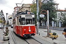
Beyoğlu is the center of modern Istanbul, which can also be seen in the numerous buildings from the turn of the 20th century, which were built in Art Nouveau or Historicism , after most of the previously common wooden houses were destroyed by a major fire in 1870 . From the highest point, Taksim Square (Taksim Meydanı) in the Taksim district , which is the center of the city , a modern shopping boulevard with department stores and international shops, İstiklal Caddesi , leads down to Tünel Square . It has been closed to road traffic since the early 1990s , but has been used by a historic tram again since then. In the streets around İstiklâl Caddesi there are countless specialty shops, restaurants, snack bars, Christian churches and a bazaar. Celebrities such as Agatha Christie , Greta Garbo , Mata Hari , Sarah Bernhardt and Mustafa Kemal stayed at the traditional Pera Palace Hotel . Istanbul's Europeans have traditionally lived in Beyoğlu since its inception as a Genoese trading colony, and the Doğan Apartmanı complex is still a popular residential area for Europeans, and was home to numerous European business and media executives even before the First World War. In addition to Ortaköy, the district is also the center of nightlife with pubs, bars, clubs and discos. There are business arcades built at the beginning of the 20th century, for example the Markiz Passage . To the east of İstiklâl Caddesi, Orhan Pamuk's “Museum of Innocence” is being built in a former residential building in Dalgiç Çıkması , a fictional documentation of the life of the protagonists of the novel of the same name using everyday objects.
From Tünel-Platz one of the oldest underground trains in the world leads down to the Galata Bridge , which leads to the old town. The funicular called Tünel was opened in 1875 and overcomes a height difference of 62 m with two carriages connected by a steel cable. Initially, the railway was operated with a steam engine, the chimney of which can still be seen opposite the "mountain station", today - comparable to a chairlift - electrically via the wheel in the mountain station, which is wound by a steel cable. The journey between the two stations, which are about 500 m apart, only takes a minute.
In the quarter to the west of the Tünel, Galata , which extends into the old port on the Golden Horn, there are mostly wholesale shops for new tools, hardware, electrical and household appliances, building materials, fishing and fishing supplies in close succession.
To the northwest of İstiklâl Caddesi, across the busy parallel street Tarlabaşı Bulvarı, are some of Istanbul's poorest neighborhoods, Dolapdere , Kasımpaşa and Halıcıoğlu . The current Prime Minister of Turkey, Recep Tayyip Erdoğan , spent his youth in Kasımpaşa .
- Beyoğlu districts are (from south to north and east to west) Galata / Karaköy (named after the Karaim ), Taksim , Kasımpaşa and Halıcıoğlu .
Şişli
Cumhuriyet Caddesi, a splendid boulevard, characterizes the Şişli district, which was only opened up at the beginning of the 20th century. The Nişantaşı and Teşvikiye districts are some of the city's posh clothing shopping areas. Here is the seat of the Bulgarian Orthodox parish in Istanbul, whose Church of St. Stephen is in the Fener district .
Kâğıthane
Kâğıthane is a legendary place in Istanbul, among other things because of its role in the tulip era (Lale Devri), which although only lasted for a short time, has a special meaning in the otherwise warlike history of the Ottoman Empire because of its peacefulness.
Kâğıthane is a big city with about 350,000 inhabitants (2000). The place is believed to be older than Istanbul, the city that was founded as Byzantium. In the 17th century it was the sultan's favorite excursion destination and hunting ground, presumably because it could be easily reached by boat across the Golden Horn. The stream of the same name was a parade route for the typical local boats (kayık). During the Lale Devri era, which lasted from 1718 to 1730, Kâğıthane was the “in” place of Istanbul. During this time around 100 beautiful buildings / villas (Köşk) were built, from which the name "kiosk" is derived. The once warlike empire took a break and devoted its attention to growing tulips.
This era, which was also characterized by luxury and ostentation, ended abruptly with the Patrona Halil uprising , which bears the name of its creator: Patrona Halil. In this uprising not only the Sultan Ahmet III. murdered, but also the magnificent mansions in Kâğıthane largely destroyed. The tulip cultivars “worth gold” in the truest sense of the word emigrated to Holland shortly afterwards. The real decline of the place, which was already a popular excursion area in the Byzantine era, was sealed by industrialization in the 20th century. The beautiful stream, on which one strolled in chic boats for centuries, degenerated into an industrial cloak.
The new administration of the borough, which has been autonomous since 1987, tries to revive parts of the former glory.
Beşiktaş
In the 19th century , the Dolmabahçe Seraglio was built on the site of the silted Dolmabahçe Bay and was the Sultan's palace until 1923 . Other sights include the Dolmabahçe Mosque , St. Fokas Church , the Etz Ahayim Synagogue and the Ortaköy Mosque . Beşiktaş is home to the fish and vegetable market (Balık Çarşısı), the Inönü Stadium, the Istanbul Technical University, international hotels and the Beşiktaş and Ortaköy piers for ferry traffic. Beşiktaş is cities partner of Erlangen .
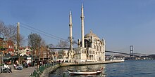
Ortaköy ('middle village'), north of Yıldız Park directly at the Bridge of the Martyrs of July 15th , is one of the most popular bars and restaurants in Istanbul, even with tourists. In the 1950s, almost only Armenian families lived there . There were numerous Armenian churches and many Armenian schools there. Step by step, the Armenians were forced to leave the country with bureaucratic harassment.
The Etiler district is one of the most expensive residential and office districts in the city. Akmerkez , one of Istanbul's largest shopping malls, is also located here . The neighboring Levent in the northwest of Beşiktaş has developed into a center for corporate and bank headquarters since the 1990s. The cityscape is dominated by high-rise buildings.
The famous traditional football club Beşiktaş JK (Jimnastik Kulübü) AG comes from this district. His home station in Dolmabahçe Inönü Stadium is also here.
Areas of Beşiktaş are (from south to north) Beşiktaş, Ortaköy, Arnavutköy , Bebek , Etiler and Levent .
Sarıyer
Sarıyer is a well-known Istanbul excursion destination. At the small port there are some fish restaurants in which fresh hamsi (small fish from the Black Sea) and other specialties can be ordered.
- Sariyer districts are (from south to north) Rumeli Hisarı, Emirgân, Baltalimanı, İstinye, Yeniköy, Tarabya , Kireçburnu, Büyükdere and Sarıyer .
Asian side
The North
Üsküdar
Üsküdar, called Chrysopolis in antiquity , Skutarion / Scutari in Byzantine times, is a spacious residential town. The cityscape with old buildings is well preserved. Including old mosques, madrasas , Islamic buildings by sheikhs and tarikats, which are still in use. From a hill in the district, the Çamlıca Hill (Turkish Çamlıca Tepesi ), which can be recognized from a long way by the antenna systems on it, you have the most beautiful view of the whole city. The landmark of Üsküdar is the Maiden's Tower (Turkish: Kız Kulesi ) located in the Bosporus , a former lighthouse , which today houses a restaurant and a café.
The Turkish First Army has its headquarters in the Selimiye Barracks ( Selimiye Kışlası ) in Üsküdar.
Istanbul's second bus station is located in the Harem district, which is adjacent to Selimiye. Mostly modern buses depart from here to almost all cities in the Anatolian part of Turkey.
- Areas of Üsküdar are (from south to north) Selimiye , Harem , Kuzguncuk , Beylerbeyi , Çengelköy , Vaniköy and Kandilli .
Umraniye
Conservative district in the Asian part of Istanbul, where there is a very high proportion of strongly religious Muslims. Ümraniye was a small village surrounded by bushland until around 1950. The place was the last exit from Istanbul in the direction of Şile , a resort on the Black Sea. Ümraniye grew stormy and uncontrolled into a big city. Although quite well connected with Istanbul, the place has the charm of a provincial city.
Beykoz
Beykoz (old Thracian name Amikos ) is one of the last green lungs of Istanbul. In no other part of Istanbul are there so many forest areas and villas. Some of the sights in Beykoz are the Egyptian Tower (Hıdiv Kasrı) of Abbas II , the Ottoman Summer Palace Küçük Su Kasrı, the old castle complex in Anadolu Hisarı and the Vehbi Koç Natural Park.
Outside Beykoz on the road to Riva is one of the curiosities of Istanbul, Polonezköy (Adampol), the Polendorf. It was founded after the Crimean War by Polish, Czech and Bohemian soldiers who decided not to return home. They built their village the local style with half-timbered houses and fenced gardens in which they planted familiar fruit trees and shrubs. The inhabitants maintain their language to this day and supply the non-Muslims living in Istanbul with pork, which is otherwise hardly available. Polonezköy has become a popular destination, with the influx of visitors, the former idyll is slowly being lost. Today a small number of Bosporus Germans also live there.
The route from Istanbul to the north is lined with a series of Yalıs that have been extensively restored. Anadolu Hisarı is home to the first Ottoman fortress that was supposed to be used for the conquest of Byzantium. It was in 1395 by Sultan Bayezid I. built. The fortress is well preserved.
- Areas of Beykoz are (from south to north) Küçüksu , Anadolu Hisarı , Kanlıca, Çubuklu, Paşabahçe , Merkez, Yalıköy and Anadolu Kavağı .
The South
Ataşehir
Ataşehir is one of the newest districts in Istanbul, which is characterized by many high-rise buildings.
Kadıköy
Kadıköy was founded around 675 BC. BC as a Megarian colony Kalchedon , later Chalcedon , under the Romans Chalcedon , founded in what was then Bithynia . The port city was south of Chrysopolis / Skutari. In its early days it shared the fate of the opposite Byzantium, was conquered by the general Otanes , torn between the interests of Sparta and Athens for a long time , and finally in 133 BC. Chr. By Attalos III. handed over to the Romans by Pergamon. 73 BC It was partially destroyed by Mithridates , but later recaptured. In 451 the Council of Chalcedon took place in the city . Chalcedony was repeatedly invaded by attacks by the barbarian peoples after they attacked Byzantium, and from 616 to 626 it was the supply point of the Persians under Chosrau II. After the conquest by the Ottomans in 1350 , its buildings were used as a quarry for the construction of Istanbul. At that time both ports had already silted up. Chalcedony is the namesake of the mineral chalcedony .
Today Kadıköy is a cosmopolitan district with numerous cinemas, restaurants, cafés and bars as well as many shopping opportunities in the old town, in the pedestrian zone and on Bağdat Caddesi (Baghdad Street ). Its old town was also shaped by the coexistence of Christians and Muslims. There are Greek Orthodox, Armenian and Roman Catholic churches. Many Armenians used to live here . Today the number of Christians has fallen sharply. Between Kadıköy and the European districts there is busy ferry traffic during the day.
Kadıköy is also home to the Fenerbahçe Istanbul sports club , whose fan motto is “Burası Kadıköy burdan cıkış yok” (“This is Kadiköy, there is no way out”).
In the Rasimpaşa district is the Haydarpaşa train station , where all trains from the east end. This station, built with German help, was the starting point for the Baghdad Railway . It was here that Florence Nightingale had achieved her reputation as "Lady with the Lamp" during the Crimean War .
Goztepe
Göztepe was once the home of wealthy city dwellers who spent the summer here. The old houses with the large gardens have largely disappeared and have been replaced by housing estates. Göztepe borders the Marmara Sea in the south and the former village of Merdivenköy in the north.
Maltepe
Kartal
Kartal means eagle and is an industrial district with a port. Kartal is known for the football club of the same name. Kartal is the seat of Siemens Turkey, formerly Simko (Siemens-Koç).
Adalar (Prince Islands, Demonesi)
The Prince Islands, Turkish Kızıl Adalar , Red Islands or more commonly Adalar (Islands) , as they are officially called; ancient Greek Πριγκήπων νήσοι Prinkēpōn nēsoi , modern Greek Πριγκηπονήσια Prinkiponisia , are a group of islands in the Sea of Marmara in front of the districts of Bostanci, Maltepe, Kartal and Pendik. With their pine and pine forests, wooden, Art Nouveau -style summer villas from the turn of the 20th century , horse-drawn carriages (motor vehicles are not allowed) and fish restaurants, they are a popular destination. They can be reached by ferries and express ferries (Deniz otobüsü) from Kabataş and Kartal. Four of the nine islands are populated and can be reached by public ferry all year round.
The main islands of the Prince Islands are called (from west to east) Kınalıada, Burgazadası, Heybeliada and Büyükada .
The East
Pendik
Pendik is named after the presumed old seat of the Byzantine general Belisarius , the Pantikapaion, of which ruins are still preserved.
East of Pendik, about four kilometers from the train station, is Istanbul's second international airport, which opened in 2001, Sabiha Gökçen Uluslararası Havaalanı . The airport is one of the first projects in the “Advanced Technology Industrial Park” that was created in Pendik.
Tuzla
Tuzla is the southernmost district of Istanbul. The place was already inhabited during the Byzantine period and was conquered by the Sultan Yıldırım Beyazıt in 1400 . The last Greek inhabitants were exchanged for Turks from Thessaloniki and Kavalla at the end of the First World War. The population, which was little more than 1,000 in World War II, exceeded 200,000 in 2005.
The formerly dominant agriculture and fishing lost their importance due to the industrialization of the place. Today there are several shipbuilding yards and the Formula 1 racetrack that opened in Tuzla in 2005 .
Web links
Individual evidence
- ↑ Official website of the municipality of Güngören: Information on the Güngören district ( memento of the original from January 3, 2007 in the Internet Archive ) Info: The archive link was inserted automatically and has not yet been checked. Please check the original and archive link according to the instructions and then remove this notice. (Turkish)
- ↑ Istanbul.net website: Information on the Güngören district ( memento of the original from January 17, 2007 in the Internet Archive ) Info: The archive link was inserted automatically and has not yet been checked. Please check the original and archive link according to the instructions and then remove this notice. (Turkish)
- ↑ Official website of the Bahcelievler District Office: Information on the population development of the Bahcelievler community ( Memento of the original from January 25, 2007 in the Internet Archive ) Info: The archive link has been inserted automatically and has not yet been checked. Please check the original and archive link according to the instructions and then remove this notice. (Turkish)
- ↑ Official website of the municipality of Bahçelievler: Information about the districts of the municipality of Bahçelievler ( Memento of the original from October 6, 2006 in the Internet Archive ) Info: The archive link has been inserted automatically and has not yet been checked. Please check the original and archive link according to the instructions and then remove this notice. (Turkish)
- ↑ Official website of the Bahcelievler District Office: Information on sights in the Bahçelievler community ( Memento of the original from December 6, 2006 in the Internet Archive ) Info: The archive link has been inserted automatically and has not yet been checked. Please check the original and archive link according to the instructions and then remove this notice. (Turkish)
- ↑ http://www.svetistephan.com/tr/ekzarh.htm
