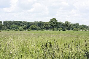
Wet meadow Hansell
|
Wet meadow Hansell
|
||
|
Nature reserve Feuchtwiese Hansell |
||
| location | North Rhine-Westphalia , Germany | |
| surface | 18 ha | |
| Identifier | ST-038 | |
| WDPA ID | 163073 | |
| Geographical location | 52 ° 3 ' N , 7 ° 33' E | |
|
|
||
| Setup date | 1984 | |
The Feuchtwiese Hansell nature reserve is located in the municipality of Altenberge in the Steinfurt district in North Rhine-Westphalia .
The area extends east of the core town of Altenberge and northeast of Hansell , a farming community in Altenberge. The state road 529 runs along the eastern edge. To the east run the district road 13, the A 1 and the B 219 , to the west run the L 510 and the B 54 . The 16.24 hectare large nature reserve (NSG) Hanseller Floth extends northeast and the 15.89 ha large NSG nature reserve Rottbusch extends south-east .
meaning
A 17.79 ha area has been designated as a nature reserve for Altenberge since 1984 under the identification number ST-038. The area has been placed under protection for conservation and development:
- two nationally important grassland complexes which, due to their respective vegetation structures in association with other wetland protected areas of great importance for the European ecological network network represent
- a wet meadow area as an important habitat for a significant tree frog population , other amphibian species and a number of dragonfly species .
See also
Web links
- Nature reserve "Feuchtwiese Hansell" (ST-038) in the specialist information system of the State Office for Nature, Environment and Consumer Protection in North Rhine-Westphalia
- World Database on Protected Areas - Feuchtwiese Hansell (English)

