Hüttrup Heath
The Hüttruper Heide is a heathland in the Grevener district of Hüttrup .
A small part of 12.3 hectares of the formerly extensive heath area between Eltingmühlenbach in the southwest, Ladberger Mühlenbach in the north and the Dortmund-Ems Canal in the east was placed under nature protection in 1938. All remaining areas were gradually made arable or afforested.
Two parts of the area under protection
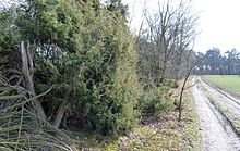
The north-eastern part of the nature reserve is a narrow wood bar with around 200 junipers that reach a height of up to 6 meters. The understory consists of wavy hair , a little heather ( Calluna vulgaris ), sheep fescue and fern . Oaks , birches and pines are increasingly pushing the junipers, which, if the shade is too strong, decline and ultimately die.
In the south-western part of the area, which is partly made up of pine forest, there is a damp depression, mainly made up of pipe grass ( Molinia caerulea ), which is filled with water in the winter months. The bell heather ( Erica tetralix ), which used to be common in the past , hardly occurs here. To this day, however, the endangered lung gentian ( Gentiana pneumonanthe ) in North Rhine-Westphalia , which has one of its largest occurrences in the Steinfurt district, has survived to this day. In 1992 more than 1000 specimens of this plant could be observed here. Despite some impairments, 25 endangered plant species have recently been found in the area. The breeding birds of the Hüttruper Heide used to include black grouse , great gray shrike and the curlew . Only the lapwing seems to be found in large numbers in the area of the protected area.
Extermination plans
The Hüttruper Heide is also the location of the Münster-Osnabrück Airport and the "Airportpark FMO" to the south. The structural concept of this industrial area provides for the destruction of the nature reserve. Even before the development of the county road 1, the Münster / Osnabrück Airport since autumn 2010 with a direct motorway access to the south tangent Federal Highway 1 connects, the landscape was deliberately devalued. Peripheral grassland of the protected area, which was only created as a buffer zone in the 1990s, was plowed up before the assessment and small bodies of water - so-called blanks , which were the spawning waters of the crested newt - were filled in. A “replacement” for the protected area to be destroyed is to be created, but it will not be able to replace the nature reserve.
literature
- Fritz Runge: The natural monuments, nature and landscape protection areas of the Steinfurt district. Series of publications of the district of Steinfurt, Volume 2, Steinfurt 1982, p. 46 u. 64
- Fritz Runge: The nature reserves of Westphalia and the former administrative district of Osnabrück. 4th improved and expanded edition, Münster 1982, p. 236
See also
Individual evidence
- ↑ Airportpark FMO: Urban structural concept: AirportPark FMO ( Memento of the original from March 9, 2013 in the Internet Archive ) Info: The archive link has been inserted automatically and has not yet been checked. Please check the original and archive link according to the instructions and then remove this notice. (PDF; 5.2 MB), Annex 3 of the public law agreement on municipal cooperation regarding the AirportPark FMO
Web links
- Nature reserve “Hüttruper Heide” (ST-011) in the specialist information system of the State Office for Nature, Environment and Consumer Protection in North Rhine-Westphalia
- Information from the city of Greven
Coordinates: 52 ° 7 ′ 19 ″ N , 7 ° 42 ′ 10 ″ E

