
Lenningen
| coat of arms | Germany map | |
|---|---|---|

|
Coordinates: 48 ° 33 ' N , 9 ° 28' E |
|
| Basic data | ||
| State : | Baden-Württemberg | |
| Administrative region : | Stuttgart | |
| County : | Esslingen | |
| Height : | 449 m above sea level NHN | |
| Area : | 41.44 km 2 | |
| Residents: | 8314 (December 31, 2018) | |
| Population density : | 201 inhabitants per km 2 | |
| Postcodes : | 73252, 73266 | |
| Area code : | 07026 | |
| License plate : | ES, NT | |
| Community key : | 08 1 16 079 | |
| Address of the municipal administration: |
Marktplatz 1 73252 Lenningen |
|
| Website : | ||
| Mayor : | Michael Bad | |
| Location of the municipality of Lenningen in the Esslingen district | ||
  |
||

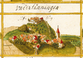
Lenningen is a municipality in the Esslingen district in Baden-Württemberg , about 10 kilometers south of Kirchheim unter Teck . It belongs to the Stuttgart region (until 1992 the Middle Neckar region ) and the peripheral zone of the European metropolitan region of Stuttgart . Lenningen is the third largest municipality in the district in terms of area. Lenningen is part of the Swabian Alb biosphere area and the UNESCO Swabian Alb Geopark .
geography
Geographical location

Lenningen lies on the edge of the Swabian Alb at 397 to 827 m above sea level. NN . In the municipal area Gutenberger or combine White Lauter and Schlatt Staller or Black Lauter to Lauter , about 13 km northwest of the municipal boundary in the Neckar flows.

The municipal area includes the entire valleys of the two source rivers and the upper valley of the Lauter, which arises from them, it ends in the west at the upper edge of the valley of the Weisser Lauter and Lauter; alone an approx. ¼ km² large, compactly built northwestern spur with the district of Hochwang protrudes from him here in the approx. 700 m above sea level. NN high Alb plateau west of this left valley range. At the top of the south edge of the right plateau above the Weißlautertal is 750 m above sea level. NN the district of Schopfloch. On this side of the right valley range, most of the Alb area between Lauter and Lindachtal also belongs to the municipality. Otherwise only the much smaller hamlet of Krebsstein and a few scattered living spaces are up here. This major part of the community area is sparsely populated, the other larger settlements are all in the valleys: Brucken is located south of Owen between the Teck in the northeast and the Albsporn Baßgeige close to the southwest before the northwest border of the community on the outflowing Lauter. Unterlenningen joins up the valley , in a wide spider from the Lautertal and the converging Ehnisbach and Kellental, overlooked by the ruins of Sulzburg on a spur remnant, and then Oberlenningen, the largest town in the municipality, in a smaller spider from the converging Tobel, Schmal - and Hirschtal is formed. Gutenberg is in the eastern tip of the Weißlautertal, while the smaller Schlattstall is in the narrower Schwarzlautertal.
Neighboring communities
Neighboring communities are in the east Wiesensteig (district of Göppingen), in the south Römerstein and Grabenstetten (both districts Reutlingen), in the west Erkenbrechtsweiler , in the north-west Owen and in the north Bissingen an der Teck and Neidlingen (all districts Esslingen).
Community structure

Lenningen consists of the seven districts of Brucken, Unterlenningen, Oberlenningen, Hochwang, Schlattstall, Gutenberg and Schopfloch and the five formerly independent communities of Gutenberg, Oberlenningen, Schlattstall, Schopfloch and Unterlenningen. The official name of the districts is identical to the district names. They form residential districts within the meaning of the Baden-Württemberg municipal code , and the districts of Gutenberg and Schopfloch form localities within the meaning of the Baden-Württemberg municipal code with their own local council and mayor . The former community of Gutenberg includes the village of Gutenberg and the hamlet of Krebsstein as well as the abandoned villages of Auf dem Heiligenberg, Sperberseck and Burg Wuelstein. The former municipality of Oberlenningen includes the village of Oberlenningen and the municipality of Hochwang, as well as the defunct Wielandstein Castle . The village of Schlattstall belongs to the former municipality of Schlattstall. The village of Schopfloch and the houses Harpprechthaus and Torfgrube belong to the former community of Schopfloch. The former municipality of Unterlenningen includes the village of Unterlenningen, the village of Brucken , Diepoldsburg Castle and the Engelhof farmstead, as well as the expired Sulzburg Castle.
Division of space

According to data from the State Statistical Office , as of 2014.
history
overview
From the Stone Age to the Middle Ages
The district of Lenningen was already settled in the Stone Age, which can be proven by legacies based on axes and pottery shards. There are also numerous artifacts from the Bronze, Celtic and Roman times. Today's federal highway 465 runs along the old Roman road between Köngen and Donnstetten. Since 300 AD the Alemanni invaded the Roman Agri decumates and also left several grave fields and traces of iron smelting in the Lenningen area. During the High Middle Ages, the area was in the Duchy of Swabia and at that time the settlement centers of today's original communities emerged. In the 12th century, the villages came under the rule of the Dukes of Teck , who ceded them to the Counts of Württemberg in 1387 . The villages became part of Altwürttembergs and have been subordinate to the office in Kirchheim ever since .
Modern times
In 1534 the Protestant Duke Ulrich ordered that all of Württemberg and thus also the villages in the Lenningen district should be Protestant from now on in accordance with the principle of " Cuius regio, eius religio ". When the new administrative structure was implemented in the Kingdom of Württemberg , which was founded in 1806 , the villages remained assigned to the Oberamt Kirchheim . The administrative reform during the Nazi era in Württemberg led to membership in the Nürtingen district in 1938 . In 1945 the localities became part of the American zone of occupation and thus belonged to the newly founded state of Württemberg-Baden , which became part of the current state of Baden-Württemberg in 1952. In the course of the district reform in Baden-Württemberg , the municipalities came to the Esslingen district in 1973 .
The municipality of Lenningen was created on January 1, 1975 through the merger of the previously independent municipalities of Gutenberg, Oberlenningen (with Hochwang and Schlattstall), Schopfloch and Unterlenningen (with Brucken).
Districts
Bridges

Brucken was first mentioned in a document in 1123 and incorporated into Unterlenningen in 1939. Brucken has 1028 inhabitants (as of December 31, 2017).
Gutenberg


The first written mention of Gutenberg comes from 1285. In 1360 it received city rights . In the 15th century - like Oberlenningen - it became the seat of a staff to which Schopfloch also belonged. The Thirty Years' War depopulated the place so much that it lost the city charter again. But Gutenberg was able to maintain the status of the staff location. The parish church of St. Nicholas was built from 1865 and consecrated on July 15, 1866. The costs amounted to 20,000 guilders and were shared between Gutenberg, Krebsstein and Schlattstall. Thirteen pastors have led the community since 1858. Gutenberg has 703 inhabitants today (as of December 31, 2017).
The "old rectory" was built in 1784 by the church council builder Wilhelm Friedrich Goez from Ludwigsburg and is now a restaurant.
Hochwang
After the Second World War, the Lenninger Valley was a refuge for displaced persons and refugees from the former East German territories (former Czechoslovakia, Yugoslavia, Hungary). These were temporarily quartered with local families as a temporary solution. Settling the displaced persons through housing projects in the Lenninger Valley was not possible without completely building up the landscape and, moreover, impossible for reasons of space. This influx of workers was not at all inconvenient for the industry in the valley, which is why the Scheufelen House gave serious thought to building a housing estate for these people in 1951. Karl Bauer, the chairman of the works council of the Scheufelen paper mill, then had the decisive idea: The municipality of Oberlenningen should buy a piece of land from the municipality of Erkenbrechtsweiler, which is exactly adjacent to Oberlenningen, but is located on the Alb plateau, in order to implement the plan for a housing estate there.
In order to have a good starting position for the negotiation with regard to the purchase of the Erkenbrechtsweiler property, the first plan was to build a road from Oberlenningen to Hochwang. The plan worked and Klaus Scheufelen (managing director of the paper mill) and Karl Bauer acquired the desired property. When the last hurdle, the water supply for the new housing estate, had been overcome, planning could begin.
After evaluating a competition for the development plan and the drafts for the settlement houses, construction could begin. The realization of the plans was entrusted to a self-founded cooperative, whose office with personnel and administrative expenses was taken over by the paper mill. The Heimatbau-Genossenschaft Lenninger Tal eGmbH consisted only of voluntary employees and the clients were not burdened financially.
For the road route to Hochwang, 250 meters of altitude were overcome and 100,000 cubic meters of earth and rock were removed by over 100 unemployed emergency workers within two and a half years. In 1954 the first vehicles drove on the new road to Hochwang. Housing construction began in September 1952, the first topping-out ceremony was celebrated just two months later and the first family was able to move in less than a year later. By the time the Heimatbau-Genossenschaft Lenninger Tal eGmbH merged with the Kreisbaugenossenschaft Nürtingen in 1971, 184 houses with 312 apartments, 62 garages and 3 commercial facilities had been built for a total billing sum of almost 9.2 million DM (4.7 Million €). At that time, one third of the population of Hochwang consisted of locals and two thirds of displaced persons. The founding of a football, ski and music club and the early construction of a kindergarten, a school, the church and the town hall branch made a positive contribution to the good coexistence. Today 684 people live in Hochwang (as of December 31, 2017).
Oberlenningen


Oberlenningen was first mentioned in a document as Lenningen around 1100. It was subordinate to the dukes of Teck , who lost it to Württemberg in 1386 . Oberlenningen was the seat of a staff, the lowest administrative division of that time, which was also responsible for Brucken, Schlattstall and Unterlenningen. Oberlenningen has 2707 inhabitants (as of December 31, 2017)
Schlattstall

The first written mention of Schlattstall comes from 1384. It belonged to the Oberlenninger staff and was incorporated into Oberlenningen on January 1, 1971. 161 people live in Schlattstall today (as of December 31, 2017).
Schopfloch


In 1152 Schopfloch was mentioned in a document. Until the formation of today's municipality of Lenningen, it was always an independent municipality, but has belonged to the Gutenberger staff since the 15th century. In the Thirty Years War, the place was so badly damaged that the population fell from 100 to 40. Today Schopfloch has 687 inhabitants (as of December 31, 2017).
Unterlenningen

Unterlenningen originally formed a unit with Oberlenningen. In 1353 the place split off and was only reunited with Oberlenningen in 1975 when today's municipality was formed. 2282 people live in Unterlenningen (as of December 31, 2017).

Bridges

Gutenberg

Cancer stone


Oberlenningen
Unterlenningen

Schopfloch


Religions
Today's districts of Lenning have been evangelical since the Reformation . In addition to the official churches, there is also a branch of the Liebenzeller Community in Brucken , which also belongs to the Protestant regional church. In Oberlenningen there is again a Roman Catholic community today . There is also a New Apostolic congregation in Oberlenningen and Brucken .
Population development
|
|
|
¹ according to the State Statistical Office of Baden-Württemberg ; until 1970 census results, from 1975 updates on December 31 of each year.
politics
Administrative association
Lenningen forms the municipal administration association Lenningen with Erkenbrechtsweiler and Owen .
Municipal council
In Lenningen, the municipal council is elected using the spurious selection process . The number of local councils can change due to overhang mandates . The municipal council in Lenningen has 18 members after the last election (unchanged). The local elections on May 26, 2019 led to the following final result. The municipal council consists of the elected voluntary councilors and the mayor as chairman. The mayor is entitled to vote in the municipal council.
| Parties and constituencies |
% 2019 |
Seats 2019 |
% 2014 |
Seats 2014 |
Local elections 2019
% 80 70 60 50 40 30th 20th 10
0
75.97%
24.03%
BWV
LEGAL / UBL
Gains / losses
compared to 2014
% p 4th 2
0
-2 -4 -3.02 % p
+ 3.02 % p
BWV
LEGAL / UBL
|
|
| BWV | Civic voters' association | 75.97 | 14th | 78.99 | 14th | |
| UWV | Lenninger Green Alternative List / Independent Citizens Lenningen | 24.03 | 4th | 21.01 | 4th | |
| total | 100.0 | 18th | 100.0 | 18th | ||
| voter turnout | 60.95% | 51.76% | ||||
mayor
Michael Schlecht was elected for a third term in March 2015 with 83.39% of the vote. He took office in 1999.
coat of arms
Blazon : "In blue over a shield base that is diagonally roughened by black and gold, a silver linden branch looped in the shape of an eight with three silver leaves on each side."
The Lenningen municipal coat of arms was designed after the municipal merger in 1975. The flag colors are yellow-blue. The teck diamonds (wecken) in the shield base are reminiscent of the shared historical relationships between the suburbs and the dukes of Teck . The linden branch is derived from the linden trees in the earlier coats of arms of Gutenberg and Unterlenningen, whose intricate shape symbolizes the togetherness of the suburbs.
Partnerships
Since 1988 Lenningen maintains partnerships to Pouilly-en-Auxois in the region Burgundy in France .
Economy and Infrastructure
traffic

The Teckbahn from Wendlingen am Neckar via Kirchheim (Teck) ends in the Oberlenningen district . The Royal Württemberg State Railways built the station buildings of Unter- and Oberlenningen in 1899 as standard stations of type IIa and IIIa, respectively. Today the hourly regional trains of DB Regio stop in the municipality at three train stations: Oberlenningen, Unterlenningen and Brucken.
The federal highway 465 Biberach –Kirchheim runs parallel to the Teckbahn in Lenningen . You can use it to reach the Kirchheim (Teck) -Ost junction of the federal motorway 8 Stuttgart - Munich, about eight kilometers to the north .
Established businesses
.jpg)
For a long time, the largest employer was the nationally known Scheufelen paper mill , which emerged in 1855 from the paper mill founded in 1773. This filed for bankruptcy in May 2019, as a result of which the last 75 jobs were completely lost after the number of employees had previously been significantly reduced in several waves.
education
In the Karl-Erhard-Scheufelen-Schulzentrum Oberlenningen there is a secondary school , a secondary school and a special needs school . There is also a primary school in Gutenberg, Oberlenningen, Schopfloch and Unterlenningen (with a branch in Brucken) . The primary school children from Schlattstall attend the Oberlenning school, while the children from Hochwang go to Erkenbrechtsweiler because of the proximity to the neighboring town . There are also seven kindergartens with a total of 14 groups in Lenningen.
Culture and sights
Museums
There is a museum for paper and book art in Lenningen. It is located in the Oberlenningen district and is also called "Schlössle". The Lenningen community library with 20,000 media (as of 2013) is also located in this building.
Buildings
The Sulzburg ruin rises above Unterlenningen over the Lauter valley. The Wielandstein ruins are located on a rocky spire on the Wielandstein .
Natural monuments
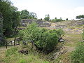
There are eight individual and 21 extensive natural monuments in the Lenningen municipality. The Schopflocher Alb nature conservation center is near Schopfloch, on the edge of an extensive natural monument, the abandoned Jura marble quarry owned by Lauster .
Near the border with the neighboring community of Grabenstetten there is a collapsed cave, the Kesselfinkenloch and the Konradfels , a tertiary volcanic vent from the Urach-Kirchheim volcanic area .
In the district of Gutenberg there is the Gußmannshöhle and the Gutenberger Höhle (both awarded as geopoints of the UNESCO Geopark Swabian Alb since September 2016 ), in the district of Schopfloch there is the Schopfloch peat bog . The Wolfsschluchthöhle is located above the village , about halfway between Gußmannshöhle and Gutenberger Höhle.

Entrance to the Gussmannshöhle

Jurassic marble quarry
Grazing by goats


Sports
The most important sports clubs are TSV Oberlenningen, TV Unterlenningen, TV Gutenberg and TSV Schopfloch. The SG Lenningen, which currently plays in handball in the regional league, is known nationwide.
Winter sports can be practiced in the Pfulb ski center in the Schopfloch district , where there are three ski lifts.
The Lenninger Tal offers excellent sport climbing opportunities and is one of the interesting climbing areas in the Swabian Alb. Numerous routes are set up on the surrounding limestone cliffs in almost all degrees of difficulty. These routes and the rocks that have been approved for them are described in numerous publications. Nature conservation regulations limit climbing activities to certain months of the year.
Personalities
Sons and daughters of the church
- Adolf Scheufelen (1864–1941), engineer and entrepreneur
- Karl-Erhard Scheufelen (1903–1992), entrepreneur
- Klaus-Heinrich Scheufelen (1913–2008), engineer, entrepreneur and politician
Personalities who have worked on site
- Albrecht Weyermann (1763–1832), clergyman and literary historian, pastor of Gutenberg
- Karl Scheufelen (1823–1902), founder of the Scheufelen paper mill
- Julius von Jan (1897–1964), pastor and resistance fighter against National Socialism, became pastor in Oberlenningen in 1935
- Willy Schneider (1907–1983), composer, music teacher and conductor
Web links
- Page from Lenningen: http://www.lenningen.de/sehenswuerdheiten_ausflugswissenschaften.html
literature
- Climbing guide Lenninger Alb , edited by Achim Pasold and Ronald Nordmann, 7th edition. Panico-Alpinverlag, Köngen 2007, ISBN 978-3-926807-72-4 .
- The district of Esslingen - published by the Baden-Württemberg State Archives. V. with the district of Esslingen, Jan Thorbecke Verlag, Ostfildern 2009, ISBN 978-3-7995-0842-1 , volume 2, page 135
Individual evidence
- ↑ State Statistical Office Baden-Württemberg - Population by nationality and gender on December 31, 2018 (CSV file) ( help on this ).
- ↑ Main statute of the municipality of Lenningen, last changed on December 8th, 2009 ( page no longer available , search in web archives ) Info: The link was automatically marked as defective. Please check the link according to the instructions and then remove this notice. (PDF; 15 kB), accessed on January 27, 2014
- ^ The state of Baden-Württemberg. Official description by district and municipality. Volume III: Stuttgart District, Middle Neckar Regional Association. Kohlhammer, Stuttgart 1978, ISBN 3-17-004758-2 . Pp. 199-203
- ↑ State Statistical Office, area since 1988 according to actual use for Lenningen.
- ^ Federal Statistical Office (ed.): Historical municipality directory for the Federal Republic of Germany. Name, border and key number changes in municipalities, counties and administrative districts from May 27, 1970 to December 31, 1982 . W. Kohlhammer, Stuttgart / Mainz 1983, ISBN 3-17-003263-1 , p. 461 .
- ^ A ray of hope for the regional bishop. Evangelical parish church Sankt Nikolaus in Gutenberg looks back on 150 years. In: DerTeckbote from July 12, 2016, page 19
- ^ Rainer Stein: The Württemberg standard station on branch lines . In: Eisenbahn-Journal Württemberg-Report . tape 1 , no. V / 96 . Merker, Fürstenfeldbruck 1996, ISBN 3-922404-96-0 , p. 80-83 .

Aichtal | Aichwald | Altbach | Altdorf | Altenriet | Baltmannsweiler | Bempflingen | Beuren | Bissingen on the Teck | Deizisau | Denkendorf | Dettingen under Teck | Erkenbrechtsweiler | Esslingen am Neckar | Filderstadt | Frickenhausen | Großbettlingen | Hochdorf | Holzmaden | Kirchheim unter Teck | Kohlberg | Kings | Leinfelden-Echterdingen | Lenningen | Lichtenwald | Neckartailfingen | Neckartenzlingen | Neidlingen | Neuffen | Neuhausen on the Fildern | Notzingen | Nürtingen | Oberboihingen | Ohmden | Ostfildern | Owen | Plochingen | Reichenbach an der Fils | Schlaitdorf | Unterensingen | Weilheim an der Teck | Wendlingen am Neckar | Wernau (Neckar) | Wolfschlugen