
Latoue
| Latoue | ||
|---|---|---|
|
||
| region | Occitania | |
| Department | Haute-Garonne | |
| Arrondissement | Saint-Gaudens | |
| Canton | Cazères | |
| Community association | Coeur et Coteaux du Comminges | |
| Coordinates | 43 ° 11 ' N , 0 ° 47' E | |
| height | 333-488 m | |
| surface | 17.62 km 2 | |
| Residents | 323 (January 1, 2017) | |
| Population density | 18 inhabitants / km 2 | |
| Post Code | 31800 | |
| INSEE code | 31278 | |

Latoue is a municipality with 323 inhabitants (as of January 1, 2017) in the Occitania region (before 2016 Midi-Pyrénées ) in southern France . It belongs to the Haute-Garonne department , the Saint-Gaudens arrondissement and the Cazères canton (until 2015 Aurignac ). The residents call themselves Latois .
geography
Latoue is about 75 kilometers southwest of Toulouse . Neighboring municipalities are Saint-Marcet in the north and northwest, Aulon in the north and northeast, Sepx in the east, Castillon-de-Saint-Martory in the southeast, Lieoux in the south, Saux-et-Pomarede in the southwest and Larcan in the west.
Population development
| year | 1962 | 1968 | 1975 | 1982 | 1990 | 1999 | 2006 | 2013 |
|---|---|---|---|---|---|---|---|---|
| Residents | 446 | 379 | 327 | 323 | 294 | 284 | 291 | 327 |
| Source: Cassini and INSEE | ||||||||
Attractions
See also: List of Monuments historiques in Latoue
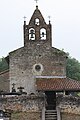
- Saint-Sernin church
- Chapel of Sainte-Radegonde
- Latoue Castle from the 13th century
Chapel of Sainte-Radegonde

Latoue Castle Tower


literature
- Le Patrimoine des Communes de la Haute-Garonne. Flohic Editions, Volume 1, Paris 2000, ISBN 2-84234-081-7 , pp. 152-156.
Web links
Commons : Latoue - collection of images, videos and audio files