
Garin
| Garin | ||
|---|---|---|
|
||
| region | Occitania | |
| Department | Haute-Garonne | |
| Arrondissement | Saint-Gaudens | |
| Canton | Bagneres-de-Luchon | |
| Community association | Pyrénées Haut Garonnaises | |
| Coordinates | 42 ° 49 ′ N , 0 ° 31 ′ E | |
| height | 1,027-2,003 m | |
| surface | 5.62 km 2 | |
| Residents | 145 (January 1, 2017) | |
| Population density | 26 inhabitants / km 2 | |
| Post Code | 31110 | |
| INSEE code | 31213 | |
 Saint-Jean-Baptiste church |
||

Garin is a French commune with 145 inhabitants (as of January 1, 2017) in the Haute-Garonne department in the Occitanie region .
geography
The municipality of Garin is located in the Larboust valley in the heart of the Pyrenees in the historic province of Comminges , about 55 kilometers south-east of Saint-Gaudens . On the Carte de Cassini , which shows France between 1756 and 1789, it still bears the name Garen . The community is on the banks of the Portet , a small tributary of the Neste d'Oô ; its inhabitants are called Garinois .
Population development
| year | 1962 | 1968 | 1975 | 1982 | 1990 | 1999 | 2007 | 2017 |
|---|---|---|---|---|---|---|---|---|
| Residents | 117 | 108 | 108 | 108 | 108 | 102 | 137 | 145 |
| Sources: Cassini and INSEE | ||||||||
Attractions
Garin's most famous building is the Romanesque Chapelle Saint-Pé de la Moraine (also Chapelle Saint-Tritous ), the construction of which began in the 10th century and was completed in the 11th century. It has had the title of Monument historique de France since 1971 . It stands on a glacier moraine . A votive altar in honor of the Pyrenees god Abellio was built into the masonry of the chapel and is now kept in the Musée Saint-Raymond in Toulouse .

Saint-Pé de la Moraine chapel

Gate of the chapel
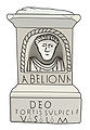
Votive altar of Abellio


literature
- Le Patrimoine des Communes de la Haute-Garonne. Flohic Editions, Volume 1, Paris 2000, ISBN 2-84234-081-7 , pp. 259-262.