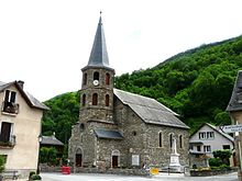
Saint-Mamet
|
Saint-Mamet Sent Memet |
||
|---|---|---|
|
|
||
| region | Occitania | |
| Department | Haute-Garonne | |
| Arrondissement | Saint-Gaudens | |
| Canton | Bagneres-de-Luchon | |
| Community association | Pyrénées Haut Garonnaises | |
| Coordinates | 42 ° 47 ' N , 0 ° 36' E | |
| height | 630-1,975 m | |
| surface | 11.16 km 2 | |
| Residents | 557 (January 1, 2017) | |
| Population density | 50 inhabitants / km 2 | |
| Post Code | 31110 | |
| INSEE code | 31500 | |
| Website | http://www.saint-mamet31.fr/ | |
Saint-Mamet ( Occitan : Sent Memet ) is a French commune with 557 inhabitants (as of January 1, 2017) in the Haute-Garonne department in the Occitanie region ; it belongs to the arrondissement of Saint-Gaudens and the association of communes Pyrénées Haut Garonnaises founded in 2016 . The inhabitants are called Saint-Mametois .
geography
Saint-Mamet is located on the right bank of the Pique in the Pyrenees and in the historic Comminges province on the border with Spain . Saint-Mamet is surrounded by the neighboring communities of Montauban-de-Luchon in the north, Bossòst (Spain) in the east and Bagnères-de-Luchon in the south and west.
Population development
| year | 1962 | 1968 | 1975 | 1982 | 1990 | 1999 | 2006 | 2011 | 2016 |
| Residents | 365 | 392 | 410 | 442 | 491 | 499 | 525 | 557 | 545 |
| Source: Annuaire-mairie and INSEE | |||||||||
Attractions
- Saint-Mamet Church
- Sidonie waterfall
supporting documents
Web links
Commons : Saint-Mamet - collection of images, videos and audio files

