Legal
| Legal | ||
|---|---|---|
|
|
||
| region | Occitania | |
| Department | Haute-Garonne | |
| Arrondissement | Saint-Gaudens | |
| Canton | Bagneres-de-Luchon | |
| Community association | Pyrénées Haut Garonnaises | |
| Coordinates | 42 ° 49 ′ N , 0 ° 29 ′ E | |
| height | 1,240–2,093 m | |
| surface | 5.79 km 2 | |
| Residents | 20 (January 1, 2017) | |
| Population density | 3 inhabitants / km 2 | |
| Post Code | 31110 | |
| INSEE code | 31242 | |
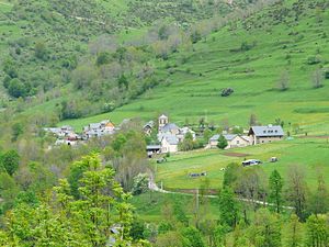
 View of Jurvielle |
||
Jurvielle is a French commune with 20 inhabitants (as of January 1, 2017) in the Haute-Garonne department in the Occitanie region ; it belongs to the arrondissement of Saint-Gaudens and the association of communes Pyrénées Haut Garonnaises founded in 2016 . The inhabitants are called Jurviellois .
geography
The municipality of Jurvielle is located in the high mountain landscape of the central Pyrenees in the south of the historical province of Comminges , about 60 kilometers southwest of Saint-Gaudens and about 20 kilometers from the border with Spain . The 5.79 km² municipal area borders the Hautes-Pyrénées department in the north-west and includes the catchment area of the Ruisseau de Labach mountain river (in the lower area of Ruisseau du Portet ) with its numerous side valleys. The mountain slopes are partially forested from about 1350 m above sea level to the tree line (here at about 1700 m). The Ruisseau du Portet drains over the Neste d'Oô and the Pique to the Garonne . The valleys are flanked by mountain peaks that rise above the 2000 m mark. Jurvielle is surrounded by the neighboring communities of Bourg-d'Oueil in the north, Poubeau in the east, Portet-de-Luchon in the south, Mont in the west and Cazaux-Fréchet-Anéran-Camors in the north-west.
The highest points in the municipality of Jurvielle are:
|
|
The GRP (Grande Randonnée de Pays) Tour d'Oueil - Larboust regional hiking trail crosses the municipal area of Jurvielle from the village of Jurvielle in the south to the 1992 m high Port de Pinate pass . |
Population development
| year | 1846 | 1962 | 1968 | 1975 | 1982 | 1990 | 1999 | 2008 | 2016 |
| Residents | 168 | 40 | 49 | 31 | 19th | 18th | 15th | 20th | 20th |
| Source: Cassini and INSEE | |||||||||
Attractions
- Saint-Christophe Church, Monument historique
- Watermill on the border with the municipality of Portet-de-Luchon
- three wayside crosses
Economy and Infrastructure
Jurvielle is a very small mountain village with a few tourist offers (holiday apartments). Despite the guaranteed snow, the ski circuit has not yet reached Kurvielle. There are two farms in the municipality (goat and sheep breeding).
Jurvielle can only be reached via an access road from the south from Portet-de-Luchon . The Col de Peyresourde pass, located five kilometers to the southwest, leads into the Nestetal . In the small town of Bagnères-de-Luchon , 11 kilometers to the east, there is a connection to the Route nationale 125 .
literature
- Le Patrimoine des Communes de la Haute-Garonne. Flohic Editions, Volume 1, Paris 2000, pp. 265-268.
supporting documents
- ↑ Jurvielle on cassini.ehess.fr
- ↑ Jurvielle on insee.fr
- ↑ Saint-Christophe Church in the Base Mérimée of the French Ministry of Culture (French)
- ↑ Farms on annuaire-mairie.fr


