
Estancarbon
|
Estancarbon Estanhcarbon |
||
|---|---|---|
|
||
| region | Occitania | |
| Department | Haute-Garonne | |
| Arrondissement | Saint-Gaudens | |
| Canton | Saint-Gaudens | |
| Community association | Coeur et Coteaux du Comminges | |
| Coordinates | 43 ° 6 ' N , 0 ° 47' E | |
| height | 325-392 m | |
| surface | 6.23 km 2 | |
| Residents | 606 (January 1, 2017) | |
| Population density | 97 inhabitants / km 2 | |
| Post Code | 31800 | |
| INSEE code | 31175 | |
| Website | http://www.estancarbon.com/ | |
 Mairie Estancarbon |
||

Estancarbon ( Occitan Estanhcarbon ) is a French commune with 606 inhabitants (as of January 1, 2017) in the Haute-Garonne department in the Occitania region ; it is part of the arrondissement of Saint-Gaudens and the canton of Saint-Gaudens . The inhabitants are called Estancarbonais .
geography
Estancarbon is located in the historic province of Comminges at the foot of the Pyrenees and on the banks of the Garonne , about 80 kilometers southwest of Toulouse . Estancarbon is surrounded by the neighboring communities of Landorthe in the north, Savarthès in the north and northeast, Labarthe-Inard in the east, Pointis-Inard in the south and southeast, Miramont-de-Comminges in the south and southwest and Saint-Gaudens in the west.
Population development
| year | 1962 | 1968 | 1975 | 1982 | 1990 | 1999 | 2006 | 2017 |
|---|---|---|---|---|---|---|---|---|
| Residents | 314 | 313 | 398 | 465 | 509 | 530 | 542 | 606 |
| Sources: Cassini and INSEE | ||||||||
Attractions
- Notre-Dame church
- Mariande Castle from the 14th / 15th centuries century
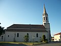
Notre-Dame church

Mariande Castle

Virgin Mary statue
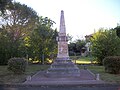
Fallen memorial

primary school


literature
- Le Patrimoine des Communes de la Haute-Garonne. Flohic Editions, Volume 2, Paris 2000, ISBN 2-84234-081-7 , pp. 1334-1335.