
Saint-Pé-d'Ardet
| Saint-Pé-d'Ardet | ||
|---|---|---|
.svg)
|
|
|
| region | Occitania | |
| Department | Haute-Garonne | |
| Arrondissement | Saint-Gaudens | |
| Canton | Bagneres-de-Luchon | |
| Community association | Pyrénées Haut Garonnaises | |
| Coordinates | 42 ° 59 ′ N , 0 ° 40 ′ E | |
| height | 575-1,001 m | |
| surface | 3.47 km 2 | |
| Residents | 148 (January 1, 2017) | |
| Population density | 43 inhabitants / km 2 | |
| Post Code | 31510 | |
| INSEE code | 31509 | |
| Website | Mairie Saint-Pé-d'Ardet | |
 View of Saint-Pé-d'Ardet |
||

Saint-Pé-d'Ardet is a municipality with 148 inhabitants (at January 1, 2017) in the Haute-Garonne of the region Occitania in the south-west of France .
geography
Saint-Pé-d'Ardet is about 18 kilometers south of Saint-Gaudens .
Population development
| year | 1962 | 1968 | 1975 | 1982 | 1990 | 1999 | 2006 | 2016 |
| Residents | 112 | 101 | 98 | 117 | 116 | 114 | 123 | 148 |
| Sources: Cassini and INSEE | ||||||||
Attractions
In the center of the village, at the highest point, is the Romanesque church of Saint-Pierre (Saint Peter) from the 11th century . A number of relics are kept in a shrine in it . There are also numerous frescoes from the 15th century. The church has been a monument historique since 1956 .
- Saint-Pierre church

Tower of the Saint-Pierre church

Fresco Entombment of Christ
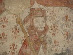
Fresco Saint Jacob


literature
- Le Patrimoine des Communes de la Haute-Garonne. Flohic Editions, Volume 1, Paris 2000, ISBN 2-84234-081-7 , pp. 342-344.
Web links
Commons : Saint-Pé-d'Ardet - Collection of images, videos and audio files
- Private website of the place (French)