Cierp-Gaud
|
Cierp-Gaud Cièrp e Gaud |
||
|---|---|---|
|
|
||
| region | Occitania | |
| Department | Haute-Garonne | |
| Arrondissement | Saint-Gaudens | |
| Canton | Bagneres-de-Luchon | |
| Community association | Pyrénées Haut Garonnaises | |
| Coordinates | 42 ° 55 ' N , 0 ° 38' E | |
| height | 460-1,894 m | |
| surface | 13.9 km 2 | |
| Residents | 734 (January 1, 2017) | |
| Population density | 53 inhabitants / km 2 | |
| Post Code | 31440 | |
| INSEE code | 31144 | |
| Website | https://www.cierpgaud.fr/ | |
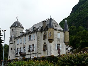
 Castle (also town hall [Mairie]) by Cierp-Gaud |
||
Cierp-Gaud ( Occitan Cièrp e Gaud ) is a French commune with 734 inhabitants (as of January 1, 2017) in the Haute-Garonne department in the Occitania region (before 2016 Midi-Pyrénées ). The municipality belongs to the arrondissement of Saint-Gaudens and the canton of Bagnères-de-Luchon (until 2015 Saint-Béat ). The inhabitants are called Cierpois-Gaudois .
location
Cierp-Gaud is located about 90 kilometers southwest of Toulouse on the Pique . Cierp-Gaud is surrounded by the neighboring communities of Thèbe in the north and north-west, Esténos in the north, Chaum in the north-east, Marignac in the east, Baren and Burgalays in the south and south-east, Signac in the south and south-west, Esbareich in the west and north-west and Mauléon-Barosse in the Northwest.
history
Until 1972, Cierp and Gaud were separate communities. In 1973 they merged with the Signac community to form the Cierp-Gaud-Signac community. In 1983 Signac broke away from the group. The Cierp-Gaud community has existed since then .
Population development
| year | 1962 | 1968 | 1975 | 1982 | 1990 | 1999 | 2006 | 2017 |
| Residents | 922 | 954 | 874 | 944 | 990 | 862 | 892 | 734 |
| Source: Cassini and INSEE | ||||||||
Attractions
- Notre-Dame church in Cierp
- Notre-Dame church in Gaud
- Cierp Castle from the 16th century, today's town hall
- cave
literature
- Le Patrimoine des Communes de la Haute-Garonne. Flohic Editions, Volume 2, Paris 2000, ISBN 2-84234-081-7 , pp. 1304-1306.


