
Marignac (Haute-Garonne)
| Marignac | ||
|---|---|---|

|
|
|
| region | Occitania | |
| Department | Haute-Garonne | |
| Arrondissement | Saint-Gaudens | |
| Canton | Bagneres-de-Luchon | |
| Community association | Pyrénées Haut Garonnaises | |
| Coordinates | 42 ° 55 ' N , 0 ° 39' E | |
| height | 475-2,154 m | |
| surface | 12.95 km 2 | |
| Residents | 484 (January 1, 2017) | |
| Population density | 37 inhabitants / km 2 | |
| Post Code | 31440 | |
| INSEE code | 31316 | |
_mairie.JPG) Mairie Marignac |
||

Marignac is a French commune with 484 inhabitants (as of January 1, 2017) in the Haute-Garonne department in the Occitanie region . The inhabitants are called Marignacais . The name of the place should come from the Latin word marinus (swamp).
geography
Marignac is situated in a basin, 124 km from Toulouse , 30 km from Saint-Gaudens and 3 km from Saint-Béat , near the confluence of the Garonne and Pique rivers . The French-Spanish border is around 3 km away. The Montcuq rises directly above the village , in the south of the Pic du Burat (2,154 m), from which a body of water flows through the village, the Ruisseau de Marignac , also called Le Burat . The mountain panorama is also dominated by the Pic Saillant (1,785 m) and Pic du Gar (1,756 m).
The place is on Route nationale 125 , the SNCF train station is called Marignac-Saint-Béat.
history
Thanks to Marignac's location in the Garonne river basin, the place has been around since the 10th century BC. Settled. The Garumner , namesake of the Garonne, a subdivision of the Aquitania Novenpopulani ("the nine Aquitanian peoples"), were a Liguro-Celtic people. The Romans used the marble quarries in the area and therefore built a road to Lugdunum Convenarum (now Saint-Bertrand-de-Comminges ).
The municipality was founded in the 12th century and was part of the Châtellenie des Frontignes (the border fortifications) and the Comté de Comminges in the Middle Ages . In 1268, the residents received a contract that allowed them a consular administration and the use of the mountains as a timber supplier and pasture. In 1312 Philip the Fair confiscated the goods of the Knights Templar and the King of France has been Lord of Marignac since then.
Since 2010 there has been a modernly equipped Center de Secours et d'Incendie (fire and rescue center) in Marignac , as the location at a valley crossing makes it ideal for operations.
The population rose from 553 (1793) to 831 (1846) to 880 (1926) and has since fallen continuously to 525 (2009). There is an École maternelle (for 2-6 year olds) and an École élémentaire (from 6 years of age, start of compulsory schooling in France). The only magnesium plant in France had existed here since 1917, but it was closed in 2001 and after several changes of ownership last (2011) only had five employees.
From 1914 to 1952, the electric Tramway de Marignac ran from the Marignac – Saint-Béat station to the border at Luchon with a route length of 15 km.
The writer José-Maria de Heredia (1842–1905) stayed here and wrote some of his works.
The theologian and editor Juan Luis Vives (1815–1900) is buried in the Marignac cemetery.
On July 23, 2007, Marignac was the destination of the 15th stage of the Tour de France .
Population development
| year | 1962 | 1968 | 1975 | 1982 | 1990 | 1999 | 2008 | 2017 |
| Residents | 633 | 745 | 685 | 624 | 537 | 505 | 520 | 484 |
| Sources: Cassini and INSEE | ||||||||
Attractions
The parish church of Sainte-Marie de Marignac dates from the 12th century, it was the burial chapel of the resident noble families Pardaillan , Sicard de Miramont and the Counts of Comminges until the 19th century .
The former Knights Templar Chapel of Saint Martin from 10/11. Century was renovated in 2005. It was one of the religious seats that had been confiscated by the king in 1312. The three castles d'Espouy, Sacère and Lucien Saint , as well as a watchtower from Gallo-Roman times (restored in 2003) and the fortifications along the Pique ( Rouziet, Caltefort, Moustajon, Castelvielh, Gouaux, Oô, Garin, Castelblancat ) and the Garonne ( Castech de Géry, Saint-Béat, Fos, Bezins, Eup, Chaum, Fronsac, Galié ) are sights in the vicinity. The towers mentioned were part of a chain of alarm systems that were supposed to guarantee the safety of the valleys. The oldest bridge in the village is the Pont Saint-Laurent .
The city fountain from 1878 is called Fontaine de Sabarrère or Fontaine aux canards (" Duck Fountain ").

Pic du Gar seen from Marignac
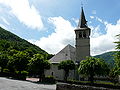
Sainte-Marie de Marignac

Coat of arms in Sainte-Marie de Marignac

Chapelle Saint Martin de Marignac

Signal tower

Fontaine de Sabarrère

_%C3%A9glise.JPG)


_tour_(1).JPG)

literature
- Le Patrimoine des Communes de la Haute-Garonne. Flohic Editions, Volume 2, Paris 2000, ISBN 2-84234-081-7 , pp. 1318-1321.
Web links
- Website of the municipality on Communes Haute-Garonne (accessed August 28, 2012)