
Mathod
| Mathod | |
|---|---|
 |
|
| State : |
|
| Canton : |
|
| District : | Jura north vaudois |
| BFS no. : | 5919 |
| Postal code : | 1438 |
| Coordinates : | 533 310 / 179933 |
| Height : | 445 m above sea level M. |
| Height range : | 431-533 m above sea level M. |
| Area : | 6.59 km² |
| Residents: | 612 (December 31, 2018) |
| Population density : | 93 inhabitants per km² |
| Website: | www.mathod.ch |
 Mathod Castle |
|
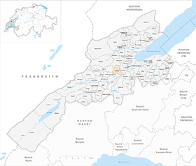
| Location of the municipality | |
  |
|
Mathod is a municipality in the Jura-Nord vaudois district in the canton of Vaud in Switzerland .
geography
Mathod is 445 m above sea level. M. , 6 km west of the district capital Yverdon-les-Bains (beeline). The clustered village extends on the northern edge of the Orbe plain , at the foot of the hills and plateaus in front of the Jura , at the outlet of the Mujon valley , in the Vaudois Central Plateau .
The area of the municipal area of 6.6 km² covers a section of the northern Vaud Central Plateau. The main part of the area is taken up by the agriculturally intensively used Orbe plain. In the south, Mathod extends over the Canal Occidental drainage canal to beyond the canalized Thielle . To the west, the municipality extends to the height of the Bois de Vuavre (up to 510 m above sea level ). The northern part includes the valley of the lower Mujon and extends into the wide valley of the Bey between the Jura foot plateau and the Mont de Chamblon . North of Mathod, at the height of the Jura foot plateau, Les Troncs at 534 m above sea level is below the farm . M. reached the highest point of the municipality. In 1997, 6% of the municipal area was in settlements, 8% in forests and woodlands, 85% in agriculture and a little less than 1% was unproductive land.
Mathod includes the hamlets of Le Moulin ( 448 m above sea level ) in the valley of the Mujon, Les Vernes ( 437 m above sea level ) in the middle of the Orbe plain north of the Thielle as well as some individual farms. The neighboring communities of Mathod are in the north Champvent , on the east Suscévaz , southeast Ependes , in the south-southeast Orbe , in the south Valeyres-sous-Rances and west Rances .
population
With 612 inhabitants (as of December 31, 2018) Mathod is one of the small communities in the canton of Vaud. 90.6% of the residents are French-speaking, 4.8% Portuguese-speaking and 3.5% German-speaking (as of 2000). The population of Mathod was 358 in 1900. After the population had decreased to 278 by 1980, a significant increase in population has been registered since then.
economy
Mathod was a predominantly agricultural village until the second half of the 20th century . Even today, arable farming (especially vegetable crops) and fruit growing play an important role in the income structure of the population. Viticulture has been practiced again on the southern slopes above the village since 1981 . Further jobs are available in small businesses and in the service sector. In the last few decades Mathod has also developed into a residential community. Numerous workers are therefore commuters who work mainly in Yverdon .
traffic
The community has good transport connections. It is located on the main road from Yverdon to Orbe . The Orbe motorway junction on the A9 , which opened in 1989, is around 4 km from the town center. There is also the Yverdon-Ouest connection to the A5 (Yverdon-Grandson) opened in 1984 in the northeast, 5 km away . Mathod is connected to the public transport network through a postbus course that runs from Yverdon to Orbe.
history
The place was first mentioned in a document in 1141 under the name Mastod . The names Mastout (1235), Mathoz (1382), Mastou , first Mathod (1403) and finally Mathoux (1521) appeared later . The origin of the place name is not known.
Mathod has belonged to the Champvent estate since the Middle Ages . At the beginning of the 14th century it came to the lords of La Mothe. With the conquest of Vaud by Bern in 1536, Mathod came under the administration of the Bailiwick of Yverdon . After the collapse of the Ancien Régime , the village belonged to the canton of Léman from 1798 to 1803 during the Helvetic Republic, which then became part of the canton of Vaud when the mediation constitution came into force . In 1798 it was assigned to the Yverdon district. The hamlet of Saint-Christophe belonged to Mathod until 1811, after which it was annexed to the municipality of Champvent.
Attractions
The Mathod Castle with two short side wings was built in the 18th century. The central building shows stylistic elements of Palladian architecture. There is a chapel next to the castle. The church opposite the castle has a tower with a rectangular floor plan as a special feature. In the center of the village there are some characteristic farm and wine-growing houses from the 17th to 19th centuries.

Village center
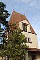
church
lock

Parish hall

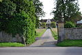
Houses in the village center

Entrance to the village with a view of Champvent Castle

Post office
_340.JPG)
_353.JPG)
_351.JPG)
_328.JPG)
_342.JPG)
_318.JPG)
_344.JPG)
Web links
- Official website of the municipality of Mathod
- Philippe Heubi: Mathod. In: Historical Lexicon of Switzerland .
- Community information
- Aerial views of the village
Individual evidence
- ↑ Permanent and non-permanent resident population by year, canton, district, municipality, population type and gender (permanent resident population). In: bfs. admin.ch . Federal Statistical Office (FSO), August 31, 2019, accessed on December 22, 2019 .
L'Abbaye | L'Abergement | Agiez | Arnex-sur-Orbe | Ballaigues | Baulmes | Bavois | Belmont-sur-Yverdon | Bioley-Magnoux | Bofflens | Bonvillars | Bretonnières | Bullet | Chamblon | Champagne | Champvent | Chavannes-le-Chêne | Chavornay | Chêne-Pâquier | Le Chenit | Cheseaux-Noréaz | Les Clées | Concise | Corcelles-près-Concise | Cronay | Croy | Cuarny | Démoret | Donneloye | Ependes | Fiez | Fontaines-sur-Grandson | Giez | Grand event | Grandson | Juriens | Le Lieu | Lignette roll | Mathod | Mauborget | Molondine | Montagny-près-Yverdon | Montcherand | Mutrux | Novalles | Onnens | Orbe | Orges | Orzens | Pomy | La Praz | Premier | Provence | Rances | Romainmôtier-Envy | Rovray | Sainte-Croix | Sergey | Suchy | Suscévaz | Tévenon | Treycovagnes | Ursins | Valeyres-sous-Montagny | Valeyres-sous-Rances | Valeyres-sous-Ursins | Vallorbe | Vaulion | Villars-Epeney | Vugelles-La Mothe | Vuiteboeuf | Yverdon-les-Bains | Yvonand
Former municipalities: Arrissoules | Chanéaz | Corcelles-sur-Chavornay | Envy | Essert-Pittet | Essert-sous-Champvent | Fontanezier | Gossens | Gressy | Mézery-près-Donneloye | Prahins | Romainmôtier | Romairon | Vaugondry | Villars-Burquin | Villars-sous-Champvent
Canton of Vaud | Districts of the canton of Vaud | Municipalities of the canton of Vaud