
Ginsheim-Gustavsburg
| coat of arms | Germany map | |
|---|---|---|

|
Coordinates: 49 ° 58 ' N , 8 ° 21' E |
|
| Basic data | ||
| State : | Hesse | |
| Administrative region : | Darmstadt | |
| Circle : | Gross-Gerau | |
| Height : | 84 m above sea level NHN | |
| Area : | 13.94 km 2 | |
| Residents: | 16,854 (Dec. 31, 2019) | |
| Population density : | 1209 inhabitants per km 2 | |
| Postal code : | 65462 | |
| Primaries : | 06134 (Gustavsburg), 06144 (Ginsheim) |
|
| License plate : | GG | |
| Community key : | 06 4 33 005 | |
City administration address : |
Schulstrasse 12 65462 Ginsheim-Gustavsburg |
|
| Website : | ||
| Mayor : | Thies Puttnins- von Trotha ( independent ) | |
| Location of the city of Ginsheim-Gustavsburg in the Groß-Gerau district | ||
  |
||

Ginsheim-Gustavsburg is a town in the northwest of the Groß-Gerau district in southern Hesse . The city borders on the state capital Wiesbaden and the state capital Mainz in Rhineland-Palatinate . It has about 17,000 inhabitants. From 1930 to 1945 the two places Ginsheim and Gustavsburg were districts of Mainz (see also districts of Mainz on the right bank of the Rhine ).
In February 2013 the community of Ginsheim-Gustavsburg was granted city rights.
geography
Geographical location

Ginsheim-Gustavsburg is located in the Mainspitze , the area south of the mouth of the Main between the Main and the Rhine opposite the city of Mainz. The 50th latitude passes through the district Gustav Burg and is characterized on the Main dam.
In the Ginsheim district, the Ginsheimer Altrhein reunites with the Rhine, from which it branches off across from Nackenheim .
Neighboring communities
Ginsheim-Gustavsburg borders in the north - separated by the Main - on the independent city of Wiesbaden and the city of Hochheim am Main ( Main-Taunus district ), in the east on the community of Bischofsheim and the city of Rüsselsheim am Main , in the south on the community of Trebur as well as in the west - separated by the Rhine - to the community of Bodenheim ( district Mainz-Bingen ) and the independent city of Mainz .
City structure
Ginsheim-Gustavsburg consists of the two districts of Ginsheim and Gustavsburg. The entire city lies within the Ginsheim district (Gmk.-Nr. 60024).
history
Ginsheim district


The Ginsheim district was first mentioned in a document in 785 in the “ Codex Eberhardi ” of the Fulda monastery. On the occasion of the 1225th anniversary, the city held a big festival in Ginsheim in 2011. A certificate from Emperor Heinrich VI was valid until 1989 . from February 1190 as the oldest known mention.
After 1248 the former Reichsdorf the Count Dieter von Katzenelnbogen had been pledged, are considered more noble ruler of the time families like Falkenstein , Sayn or Isenburg handed. In 1600 the village came into the possession of Landgrave Ludwig V of Hesse through the sale of the Kelsterbach office from the Isenburg-Ronneburg county . In the Thirty Years War, the community was so badly affected that hardly anyone lived there from 1634 to 1642.
Administratively until 1820 Ginsheim belonged to the Kelsterbach office , which from 1816 belonged to the Starkenburg province of the Grand Duchy of Hesse . In 1821 district districts were introduced in the Grand Duchy and Ginsheim was assigned to the district of Dornberg .
The statistical-topographical-historical description of the Grand Duchy of Hesse reports on Ginsheim in 1829:
“Ginsheim (L. District Dornberg) Lutheran parish village; is located 2 3 ⁄ 4 St. from Dornberg, at the confluence of the Schwarzbach in the Rhine, and has 109 houses and 763 inhabitants, up to 12 Cath., 5 Reform. and 22 Jews are all Lutheran. There are 4 Rhine mills, 1 brickworks and several ponds. Noteworthy is the so-called Römerstrasse, which begins on the Rhine, opposite Weissenau and runs towards Bischofsheim, Gustavsburg, Hof Rauchau, the Rhine islands of Körberwörth, Langau, zurückwörth and Bleiau sd Art. An institution for the poor has existed here since the end of 1827 which not only supports the poor, but also legal journeyman craftsmen. - Ginsheim was an imperial village that King Wilhelm gave to Count Diether III in 1248. pledged by Katzenellenbogen. The bailiwick belonged to the Lords of Eppenstein, who sold them to the Lords of Falkenstein in 1279, from whom they came to the Counts of Isenburg. The patronage was owned by the lords of Munzenberg, who died out in the male line in 1255 and from whom it came to the lords of Falkenstein. They gave it away in 1283 to the Padenhausen nunnery in Dreieicher Hain. However, this donation must have come back from the monastery because the Falkensteiners appear again as patron saints in 1392. This right was also asserted by their heirs, the Counts of Isenburg. In 1600 Ginsheim and the entire Kelsterbach office were purchased by Hesse. "
In 1832 the units were enlarged one more time and circles were created. This brought Ginsheim to the Groß-Gerau district. The provinces, the counties and the administrative districts of the Grand Duchy were abolished on July 31, 1848 and replaced by administrative districts, but this was reversed on May 12, 1852. As a result, Ginsheim belonged to the Darmstadt administrative district between 1848 and 1852 , before the Groß-Gerau district was again responsible for the higher-level administration. On January 1, 1930, it was incorporated into the city of Mainz as the districts of Mainz-Ginsheim and Mainz-Gustavsburg . After the Second World War , the state of Hesse was founded in 1945 and the six districts of Mainz on the right bank of the Rhine were either added to Wiesbaden or independent Hessian communities. Ginsheim-Gustavsburg became independent again and was reintegrated into the Groß-Gerau district.
The competent jurisdiction was during the affiliation to Hesse, from 1821 to 1879 the district court Großgerau and from 1879 the district court Groß-Gerau . While Ginsheim-Gustavsburg belonged to Mainz from 1930 to 1945, the Mainz District Court was responsible and, when it was returned to the Groß-Gerau district, the Groß-Gerau District Court again.
Typical Ginsheim professions of the past centuries were farmers, fishermen and millers. Milling developed into a veritable branch of industry. Up to 15 ship mills were temporarily anchored off Ginsheim. The last copy was decommissioned in 1929, listed as a historical monument, anchored in the Mainz harbor and destroyed there in a bombing attack towards the end of the Second World War. This and many other interesting chapters in local history are very clearly documented in the local history museum. A historic ship mill has been reconstructed in front of Ginsheim on the Rhine since 2011.
On April 24, 1944, at midnight in the course of the air raids on Mainz , Ginsheim was badly hit in a British air raid. Nobody was killed in the process, but 22 barns, 20 stables, three houses and the Protestant church burned down completely. The destroyed barns, stables and houses were rebuilt as early as the summer of 1944, but the Protestant church could not be consecrated until December 6, 1953. The Second World War came back to Ginsheim at the end of March 1945. The place was fiercely contested between American and German troops. But on March 28, 1945 the place surrendered and the Americans were able to march into Ginsheim. After the war, the place belonged to the American zone of occupation and then to the state of Hesse .
Gustavsburg district

The district owes its name to the Swedish king Gustav Adolf , who had a fortress built on the Mainspitze in 1632 during the Thirty Years' War . Among other things, the stone of a Roman equestrian grave was found, a copy of which now adorns the entrance hall of the town hall. In 1635 the Swedes gave up Gustavsburg, which finally came into French possession after the eventful years of war. In 1673 the Elector of Mainz, Johann Philipp von Schönborn, had the facility razed shortly before his death.
The statistical-topographical-historical description of the Grand Duchy of Hesse reports on Gustavsburg in 1829:
“Gustavsburg (L. Bez. Dornberg) vestment ruin; lies in the Ginsheim district at the so-called Mainspitze, consists of a few rubble overgrown with bushes; close by is a brickworks. Gustav Adolph had this fortress built in 1632 and the interior space for 600 houses. The fortress itself was very regular and consisted of 6 bulwarks and a single gate. When this work was put in place, there was a lot of old masonry and several statues. several inscriptions and a lamp found. In the French Murder Burn War in 1689, the inhabitants of the surrounding towns were harassed to the extreme with wars and digging work at the fortress. The fortress works were later removed and continued by name in 1693. "
The local lexicon for Germany listed Gustavsburg in 1859 as "ruin, brickworks and inn with 10 inhabitants". The brickworks, built before 1740, stood at Gustavsburger Hafen 1, today the BP tank farm. With the opening of a railway line in 1858, the Gustavsburg harbor station ended as a terminus , which was also the landing stage for the Mainz – Gustavsburg route . The other building, built in 1836, the "Gastwirtschaft zur Gustavsburg" (today Kolpingstrasse 9), was located near the confluence of the Main and the Rhine, opposite Kostheim , which was on the right of the Main and the Rhine . This inn was a contact point for traders on their way to the Mainz market, the Hessen-Darmstadt stagecoach line and a popular excursion destination on Sundays.
In 1859 the Nuremberg company Klett & Co. (later: MAN-Werk Gustavsburg ) began building a bridge over the Rhine. For this purpose, an assembly area was set up in Gustavsburg, around which workers and their families settled. It quickly developed into an industrial place. The factory also built the Kugelhaus in Dresden, which was opened in 1928 on the occasion of the annual German Labor Show - The Technical City .
On January 1, 1930, the municipality of Ginsheim-Gustavsburg became the two Mainz districts of Mainz-Ginsheim and Mainz-Gustavsburg.
Gustavsburg's strategic importance led to constant air raids by British and American aircraft squadrons during World War II (see main article: Air raids on Mainz ) . From autumn 1942 there were more attacks, from late summer 1944 there were even daily air alarms. The heaviest attack hit Gustavsburg on February 27, 1945. The main target - especially when Allied fighter-bombers attacked on March 2, 1945 - was the MAN factory. At the end of March 1945 the war was over for Gustavsburg when American troops marched in.
After the Second World War, the state of Hesse was founded in 1945, and the districts of Mainz on the right bank of the Rhine were either added to Wiesbaden or independent municipalities. Mainz-Gustavsburg became an independent municipality as Ginsheim-Gustavsburg, which was reintegrated into the Groß-Gerau district.
On September 20, 1983, the revolutionary cells carried out an explosive attack on the MAN data center. The property damage amounted to several million DM.
The city of Ginsheim-Gustavsburg was founded
In 1806 Napoleon placed Kastel , Kostheim , the Maaraue and the Rhine islands in front of it under French rule; the left bank of the Rhine had come to France as early as 1801. However, the French had no interest in the Kostheim district south of the Main, and so the area of today's Gustavsburg came to the Grand Duke Ludwig I (Hessen-Darmstadt) , who in turn assigned it to the Ginsheim district. On December 30, 1808, the then Ginsheim mayor confirmed the new acquisition. In the following years the Kostheim citizens, who still owned land south of the Main, sold their fields to Ginsheim farmers. Thus, the year 1808 is the actual hour of birth of Ginsheim-Gustavsburg.

On September 28, 1929, the Ginsheim-Gustavsburg parish council voted for incorporation into the city of Mainz. With a law of December 10, 1929, the Hessian state parliament approved the separation of the Ginsheimer district and the Ginsheimer Rheinauen from the district of Groß-Gerau and the province of Starkenburg with allocation to the district of Mainz and the province of Rheinhessen. The registry offices and the local courts were to remain under the official names Mainz-Ginsheim and Mainz-Gustavsburg until further notice . On January 1, 1930, the official incorporation took place under Lord Mayor Karl Külb .
It stayed that way until the end of World War II in 1945. In that year, the Rhine became the zone border between the American and French zones , and Ginsheim-Gustavsburg came back to the Groß-Gerau district as an independent municipality together with the Bischofsheim municipality.
After 1945, Ginsheim-Gustavsburg's economy and infrastructure grew far beyond the previously existing conditions. In the 1950s, the MAN settlement was built in the northeast and another settlement in the west of the village and in the center of the village. In the 1990s the construction of a new building area began. The integrated comprehensive school IGS Mainspitze, which was built in 1972, was also reached from the south and east.
The Hessian state government decided in February 2013 to give the municipality city rights, and the certificate was handed over on April 29, 2013.
Incorporations
On February 1, 1975, parts of the neighboring community of Bischofsheim with around 80 inhabitants were incorporated.
Territorial history and administration
The following list gives an overview of the territories in which Ginsheim and Gustavsburg were located and the administrative units to which they were subordinate:
Ginsheim:
- before 1600: Holy Roman Empire , County Isenburg-Ronneburg , (1556: Amt Langen, later Amt Kelsterbach )
- from 1600: Holy Roman Empire, Landgraviate Hessen-Darmstadt (by purchase), Upper County Katzenelnbogen , Kelsterbach office
- from 1806: Confederation of the Rhine , Grand Duchy of Hesse , Principality of Starkenburg, Kelsterbach Office
- from 1815: German Confederation , Grand Duchy of Hesse, Province of Starkenburg , Gernsheim Office
- from 1821: German Confederation, Grand Duchy of Hesse, Starkenburg Province, Dornberg District District (separation between justice ( Groß-Gerau District Court ) and administration)
- from 1832: German Confederation, Grand Duchy of Hesse, Province of Starkenburg, District of Groß-Gerau
- from 1848: German Confederation, Grand Duchy of Hesse, Darmstadt administrative district
- from 1852: German Confederation, Grand Duchy of Hesse, Province of Starkenburg, District of Groß-Gerau
- 1860: the town of Gustavsburg is created
- from 1866: Grand Duchy of Hesse, Starkenburg Province, Groß-Gerau district
- from 1871: German Empire , Grand Duchy of Hesse, Starkenburg Province, Groß-Gerau district
- from 1918: German Empire, People's State of Hesse , Starkenburg Province, Groß-Gerau district
- In 1927 Gustavsburg was merged with the community of Ginsheim
- on January 1, 1930 to the city of Mainz as the Mainz-Gustavsburg district
- from 1930: German Empire, People's State of Hesse, Province of Rheinhessen , city district of Mainz
- from 1938: German Empire, People's State of Hesse, Stadtkreis Mainz (In the course of the regional reform in 1938 , the three Hessian provinces of Starkenburg, Rheinhessen and Upper Hesse are dissolved.)
- from 1945: American occupation zone, Greater Hesse , Darmstadt administrative district, Gross-Gerau district
- On October 16, 1945 the community of Ginsheim-Gustavsburg was re-established (the districts of Mainz-Ginsheim and Mainz-Gustavsburg were separated from the city of Mainz)
- from 1949: Federal Republic of Germany , State of Hesse , Darmstadt district, Groß-Gerau district
population
Population structure
According to the 2011 census , there were 15,701 residents in Ginsheim-Gustavsburg on May 9, 2011. These included 2,127 (13.5%) foreigners of whom 741 came from outside the EU , 1140 from other European countries and 246 from other countries. Of the German residents, 18.2% had a migration background . The inhabitants lived in 7267 households. Of these, 2511 were single households , 1907 were couples with children and 32195 were couples without children, as well as 489 single parents and 186 shared apartments .
Population development
| • 1791: | 451 inhabitants |
| • 1800: | 451 inhabitants |
| • 1806: | 524 inhabitants, 87 houses |
| • 1829: | 763 inhabitants, 109 houses |
| • 1867: | 1244 inhabitants, 193 houses |
| Ginsheim-Gustavsburg: Population from 1791 to 2015 | ||||
|---|---|---|---|---|
| year | Residents | |||
| 1791 | 451 | |||
| 1800 | 451 | |||
| 1806 | 524 | |||
| 1829 | 763 | |||
| 1834 | 784 | |||
| 1840 | 854 | |||
| 1846 | 838 | |||
| 1852 | 951 | |||
| 1858 | 1,035 | |||
| 1864 | 1,263 | |||
| 1871 | 1,423 | |||
| 1875 | 1,449 | |||
| 1885 | 1,546 | |||
| 1895 | 1,861 | |||
| 1905 | 3,501 | |||
| 1910 | 3,791 | |||
| 1925 | 4,611 | |||
| 1939 | 5,730 | |||
| 1946 | 8,122 | |||
| 1950 | 9,200 | |||
| 1956 | 10,261 | |||
| 1961 | 12,135 | |||
| 1967 | 14,646 | |||
| 1970 | 15,494 | |||
| 1972 | 15,588 | |||
| 1976 | 15,488 | |||
| 1984 | 15.106 | |||
| 1992 | 14,868 | |||
| 2000 | 15,100 | |||
| 2005 | 16,103 | |||
| 2010 | 15,913 | |||
| 2011 | 15,701 | |||
| 2015 | 16,143 | |||
| Data source: Historical municipality register for Hesse: The population of the municipalities from 1834 to 1967. Wiesbaden: Hessisches Statistisches Landesamt, 1968. Further sources:; 1972 :; 1976 :; 1984 :; 1992 :; 2000 :; 2005 :; 2010 :; 2011 census; 2015: | ||||
Religious affiliation
| • 1829: | 724 Lutheran (= 94.68%), 5 Reformed (= 0.65%), 22 Jewish (= 2.89%) and 12 Catholic (= 1.57%) residents |
| • 1961: | 6737 Protestant (= 55.52%) and 4636 Catholic (= 38.20%) residents |
| • 2011: | 4650 Protestant (= 29.5%), 4550 Catholic (= 29.1%), 120 free church (= 0.8%), 250 Orthodox (= 1.6%), 640 non-believers (= 4.1%), 5450 other (= 34.7%) residents |
Gainful employment
The municipality in comparison with the district, administrative district Darmstadt and Hesse:
| year | local community | district | Administrative district | Hesse | |
|---|---|---|---|---|---|
| Employees subject to social security contributions | 2017 | 5,547 | 98,042 | 1,695,567 | 2,524,156 |
| Change to | 2000 | + 61.3% | + 5.4% | + 16.1% | + 16.0% |
| of which full-time | 2017 | 81.9% | 75.9% | 72.8% | 71.8% |
| of which part-time | 2017 | 16.1% | 24.1% | 27.2% | 28.2% |
| Only marginally paid employees | 2017 | 863 | 13,048 | 224.267 | 372.991 |
| Change to | 2000 | + 79.4% | −9.6% | + 9.0% | + 8.8% |
| Branch | year | local community | district | Administrative district | Hesse |
|---|---|---|---|---|---|
| Manufacturing | 2000 | 51.8% | 43.8% | 27.0% | 30.6% |
| 2017 | 36.8% | 33.2% | 20.4% | 24.3% | |
| Commerce, hospitality and transport | 2000 | 24.7% | 27.6% | 26.4% | 25.1% |
| 2017 | 35.2% | 27.9% | 24.7% | 23.8% | |
| Business services | 2000 | 9.1% | 14.0% | 25.1% | 20.2% |
| 2017 | 15.2% | 19.9% | 31.6% | 26.1% | |
| other services | 2000 | 13.9% | 13.7% | 20.1% | 22.5% |
| 2017 | 12.4% | 18.6% | 23.0% | 25.4% | |
| Other (or without assignment) | 2000 | 0.5% | 1.0% | 1.4% | 1.5% |
| 2017 | 0.3% | 0.5% | 0.3% | 0.4% |
politics
City Council
The local elections on March 6, 2016 produced the following results, compared to previous local elections:
| Parties and constituencies |
% 2016 |
Seats 2016 |
% 2011 |
Seats 2011 |
% 2006 |
Seats 2006 |
% 2001 |
Seats 2001 |
||
| SPD | Social Democratic Party of Germany | 35.5 | 13 | 43.6 | 16 | 53.2 | 20th | 54.7 | 20th | |
| CDU | Christian Democratic Union of Germany | 22.8 | 9 | 24.8 | 9 | 22.6 | 8th | 30.9 | 11 | |
| GREEN | Alliance 90 / The Greens | 7.8 | 3 | 16.9 | 6th | 8.6 | 3 | 10.4 | 4th | |
| FW GiGu | Free voters Ginsheim - Gustavsburg | 30.5 | 11 | 12.1 | 5 | 12.4 | 5 | - | - | |
| FDP | Free Democratic Party | 3.4 | 1 | 2.6 | 1 | 3.2 | 1 | 4.0 | 2 | |
| total | 100.0 | 37 | 100.0 | 37 | 100.0 | 37 | 100.0 | 37 | ||
| Voter turnout in% | 46.7 | 44.9 | 48.2 | 54.0 | ||||||
The chairman of the city council is the city council chief Mario A. Bach, a member of the CDU parliamentary group.
mayor
According to the Hessian municipal constitution, the mayor is chairman of the magistrate , which in the city of Ginsheim-Gustavsburg includes seven honorary councilors in addition to the mayor . Mayor has been the non-party Thies Puttnins-von Trotha since June 15, 2016. His directly elected predecessors were
- 1992 to 2016 Richard von Neumann (SPD)
Partnerships
Ginsheim-Gustavsburg had been related to the French city of Bouguenais and the Senegalese rural community of Ballou since 1989 . In 2009 this three-way partnership was terminated by Bouguenais , but is to be continued as a two-way partnership between Ginsheim-Gustavsburg and Bouguenais.
Culture and sights
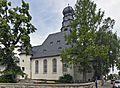
Sights in the Ginsheim district are the Old Rhine and Rheinauen, the marina, the Protestant Baroque church, which was built in 1746 as a baroque hall building with a three-sided end, as well as the local museum and the historic industrial crane in the harbor.
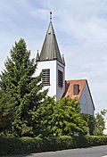
Sights in the Gustavsburg district are the Mainschleuse, the Mainspitze, the Catholic Church of the Sacred Heart of Jesus and the Evangelical Gustav Adolf Church. Furthermore, the listed Cramer-Klett settlement with the steel houses built by MAN in the years after the Second World War . A Christmas market is held there every year in front of its romantic backdrop.
The largest festival in the club is the Castle Festival (Whitsun). This festival in Gustavsburg is intended to commemorate the unusually splendid imperial festival at Whitsun 1184 with 40,000 visitors from the Hohenstaufen emperor Friedrich I Barbarossa (1122–1190) on the neighboring Rhine island of Maaraue near Kostheim.
The idyllic location on the Old Rhine with the offshore islands of Nonnenau (Old Rhine ferry "Johanna"), Langenau and Rabenwörth and the picturesque Rheinauen have made Ginsheim a popular local recreation area.
The Altrheinfest - organized by the local associations on the first weekend in June - also attracts many visitors from outside the city.
In June 2011 a mosque was built by the community of Ahmadiyya Muslim Jamaat in the industrial area of Ginsheim-Gustavsburg. The Bait-ul-Ghafur-Mosque is built in classical Islamic sacral architecture with a dome and minaret . It contains Islamic calligraphy on the exterior and interior . The community regularly invites visitors to tour the mosque and to engage in interfaith dialogues. The mosque was opened by the caliph Hadhrat Mirza Masroor Ahmad , the spiritual leader of the Ahmadiyya Muslim Community . In the immediate vicinity is also the Alevis community , many of whom come from neighboring Rüsselsheim .
- Sights in Ginsheim

The town hall in Ginsheim

Local museum
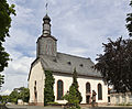
Evangelical Church Ginsheim
Catholic Church of St. Mary

Ship mill from 2011

Bait-ul-Ghafur mosque


_2.jpg)
- Ginsheim-Gustavsburg with the Rhine island Langenau

Main mouth - left of the Rhine - Ginsheim-Gustavsburg with Rhine island Langenau

Ginsheim-Gustavsburg with the Rhine island Langenau, also called Nonnenau

Ginsheim-Gustavsburg, Hofgut Langenau on the Rhine island of Langenau

Ginsheim-Gustavsburg, Hofgut Langenau on the Rhine island of Langenau

Ginsheim-Gustavsburg, Hofgut Langenau on the Rhine island of Langenau


- Sights in Gustavsburg

The town hall in Gustavsburg
Evangelical Gustav Adolf Church

Catholic Sacred Heart Church


Economy and Infrastructure
Land use
The municipal area covers a total area of 1394 hectares, of which in hectares are:
| Type of use | 2011 | 2015 | |
|---|---|---|---|
| Building and open space | 293 | 295 | |
| from that | Living | 148 | 147 |
| Business | 76 | 83 | |
| Operating area | 45 | 45 | |
| from that | Mining land | 0 | 0 |
| Recreation area | 66 | 58 | |
| from that | Green area | 37 | 37 |
| traffic area | 121 | 120 | |
| Agricultural area | 437 | 433 | |
| from that | moor | 0 | 0 |
| pagan | 0 | 0 | |
| Forest area | 47 | 47 | |
| Water surface | 337 | 340 | |
| Other use | 48 | 46 | |
Road traffic
The place is connected to the national road network via the A 60 (from Mainz over the Weisenauer Brücke and from Frankfurt) and A 671 (from Wiesbaden ). The Mainspitz triangle , which connects these two motorways, is located between the two districts . Bundesstraße 43 runs through the Gustavsburg district . The Kostheimer Brücke connects the city with the neighboring Wiesbaden district of Mainz-Kostheim across the Main .
Rail transport

The barrier-free three-track through station Mainz-Gustavsburg on the main line Mainz - Frankfurt is located southwest of the district ( 49 ° 59 ′ 39.9 ″ N , 8 ° 18 ′ 50.5 ″ E ). Since Gustavsburg was a district of Mainz between the world wars and the station was not renamed afterwards, the addition "Mainz-" has been retained. It is served by S-Bahn trains on line S 8 (Hanau - Frankfurt Hbf - Frankfurt Airport - Mainz - Wiesbaden) every half hour and from Monday to Saturday (the trains do not stop here on Sundays) by regional trains on line 75 (Aschaffenburg - Darmstadt - Mainz - Wiesbaden) of the RMV every hour.
Bus transport
The bus line 54 of the Mainz-Wiesbaden transport association (VMW ) operated by the Mainzer Verkehrsgesellschaft (MVG) has been connecting Gustavsburg train station with the Wiesbaden districts of Mainz-Kostheim and Mainz-Kastel as well as with the city of Mainz since the timetable change in December 2019; previously the line had not reached the station. The Ginsheim district is also served by VMW lines 56 and 58 (from Mainz, also via Mainz-Kastel and Mainz-Kostheim). The VMW line 60 connects Ginsheim directly over the Weisenauer Bridge with Mainz. All bus routes are part of the Rhein-Main-Verkehrsverbund .
port
In the Gustavsburg district there is a Rhine port just above the railway bridge to Mainz . He linked as the transfer of goods with siding the federal waterways Rhine and Main with the railway network of the railway junction Bischofsheim and additionally via the fast attainable Mainspitz triangle with the motorways of the Rhine-Main area. From 1967 a large tank farm was built here with 28 high-level tanks for a total of 286,000 cubic meters of petrol, super petrol, super plus, diesel, aviation petrol and heating oil. A pipeline from the port of Rotterdam and a pipeline to Frankfurt am Main Airport are used to handle fuel at the tank farm .
In addition to the tank port, HTAG Häfen und Transport AG handles 650,000 tons of goods annually in port basin IV on 100,000 square meters of storage and water area and 1200 meters of quays. It also operates two sidings in the port area, which ensure fast and efficient block train handling . There are various loading facilities such as loading ramp, cranes or your own shunting locomotive. In 2016, a container terminal for ship and road traffic went into operation in the immediate vicinity of the mouth of the Main.
The first lock on the Main is located in Gustavsburg, coming from the Rhine, although it is in the district, the official name is: Kostheim barrage .
Personalities
- Gustav II Adolf (Sweden) (1594–1632), King of Sweden, founder of the fortress and city of Gustavsburg
- Karl Külb (1870–1943), Lord Mayor of Mainz, in 1930 responsible for the incorporation of Ginsheim and Gustavsburg
- Otto Kirschmer (1898–1967), physicist; Head of the MAN materials testing institute in Ginsheim-Gustavsburg
- Jo Brenneis (1910–1994), painter; Draftsman at MAN Ginsheim-Gustavsburg
- Enno Siehr (* 1947), politician (SPD), councilor and mayor of Ginsheim-Gustavsburg, later district administrator of the Groß-Gerau district
literature
- Literature on Ginsheim-Gustavsburg in the Hessian Bibliography
- Publications about Ginsheim-Gustavsburg in the catalog of the German National Library
Web links
- Website of the city of Ginsheim-Gustavsburg
- Ginsheim-Gustavsburg In: Website of the Groß-Gerau district
- Ginsheim-Gustavsburg, Groß-Gerau district. Historical local dictionary for Hessen. In: Landesgeschichtliches Informationssystem Hessen (LAGIS).
- Information on the community of Ginsheim-Gustavsburg. In: Hessisches Gemeindelexikon. HA Hessen Agentur GmbH , 2016.
- Ginsheim with a history. In: www.rhoischnoke.de. Private website
- Link catalog on the topic of the community of Ginsheim-Gustavsburg at curlie.org (formerly DMOZ )
Individual evidence
- ↑ Hessian State Statistical Office: Population status on December 31, 2019 (districts and urban districts as well as municipalities, population figures based on the 2011 census) ( help ).
- ↑ a b c Ginsheim-Gustavsburg receives city rights. Press release. Hessian Ministry of the Interior and for Sport , February 21, 2013, accessed on August 10, 2015 .
- ↑ a b Cabinet resolution on the community side ( Memento from February 22, 2014 in the Internet Archive ) (accessed on February 22, 2012)
- ↑ rhoischnoke.de , accessed on September 23, 2013
- ↑ Erhard Nietzschmann: The free in the country. Former German imperial villages and their coats of arms. Melchior, Wolfenbüttel 2013, ISBN 978-3-944289-16-8 , p. 35.
- ↑ a b c Ginsheim, Groß-Gerau district. Historical local lexicon for Hesse (as of July 23, 2012). In: Landesgeschichtliches Informationssystem Hessen (LAGIS). Hessian State Office for Historical Cultural Studies (HLGL), accessed on November 13, 2012 .
- ^ A b c Georg Wilhelm Justin Wagner : Statistical-topographical-historical description of the Grand Duchy of Hesse: Province of Starkenburg . tape 1 . Carl Wilhelm Leske, Darmstadt October 1829, OCLC 312528080 , p. 85 ( online at google books ).
- ^ Association of Historical Rheinschiffsmühle Ginsheim e. V.
- ^ Georg W. Wagner: Statistical-topographical-historical description of the Grand Duchy of Hesse: Province of Starkenburg . tape 1 . Carl Wilhelm Leske, Darmstadt October 1829, p. 94 ( online at Google Books ).
- ↑ Chronicle Gustavsburg. Retrieved January 23, 2015 .
- ^ Georg Seiring (ed.) / Marta Fraenkel : 10 years of exhibition work in Dresden . Dresden 1931, pp. 142-145
- ^ A b Gustavsburg, district of Groß-Gerau. Historical local lexicon for Hesse (as of November 8, 2010). In: Landesgeschichtliches Informationssystem Hessen (LAGIS). Hessian State Office for Historical Cultural Studies (HLGL), accessed on November 13, 2012 .
- ↑ Law concerning the ... union of the rural communities of Bischofsheim, Ginsheim-Gustavsburg, Bretzenheim and Weisenau with the city of Mainz of December 12, 1929 . In: Hessisches Gesamtministerium (Hrsg.): Hessisches Regierungsblatt. 1929 No. 18 , p. 193–195 ( online at the information system of the Hessian state parliament [PDF; 23.1 MB ]). also corresponding announcement by the Hessian Ministry of the State of the same date and announcement by the Hessian Minister of the Interior of December 13, 1929 (Reg.-Bl. No. 20 pp. 213-214)
- ^ MAN settlement in Ginsheim-Gustavsburg
- ↑ IGS Integrated Comprehensive School Mainspitze
- ^ Federal Statistical Office (ed.): Historical municipality directory for the Federal Republic of Germany. Name, border and key number changes in municipalities, counties and administrative districts from May 27, 1970 to December 31, 1982 . W. Kohlhammer, Stuttgart / Mainz 1983, ISBN 3-17-003263-1 , p. 366 .
- ↑ a b c Ginsheim-Gustavsburg, district of Groß-Gerau. Historical local dictionary for Hessen. (As of March 23, 2018). In: Landesgeschichtliches Informationssystem Hessen (LAGIS).
- ^ Michael Rademacher: German administrative history from the unification of the empire in 1871 to the reunification in 1990. State of Hesse. (Online material for the dissertation, Osnabrück 2006).
- ^ Grand Ducal Central Office for State Statistics (ed.): Contributions to the statistics of the Grand Duchy of Hesse . tape 1 . Darmstadt 1866, p. 43 ff . ( online at Google Books ).
- ↑ Population according to nationality groups: Gernsheim, Stadt. In: Zensus2011. Bavarian State Office for Statistics , accessed in May 2015 .
- ↑ Migration background in%: Gernsheim, city. In: Zensus2011. Bavarian State Office for Statistics , accessed in May 2015 .
- ^ Households by family: Gernsheim, city. In: Zensus2011. Bavarian State Office for Statistics , accessed in May 2015 .
- ↑ Hessen-Darmstadt state and address calendar 1791 . In the publishing house of the Invaliden-Anstalt, Darmstadt 1791, p. 121 ( online in the HathiTrust digital library ).
- ↑ Hessen-Darmstadt state and address calendar 1800 . In the publishing house of the Invaliden-Anstalt, Darmstadt 1800, p. 122 ( online in the HathiTrust digital library ).
- ↑ List of offices, places, houses, population. (1806) HStAD inventory E 8 A No. 352/4. In: Archive Information System Hessen (Arcinsys Hessen), as of February 6, 1806.
- ^ Ph. AF Walther : Alphabetical index of the residential places in the Grand Duchy of Hesse . G. Jonghaus, Darmstadt 1869, OCLC 162355422 , p. 30 ( online at google books ).
- ^ Local elections 1972; Relevant population of the municipalities on August 4, 1972 . In: The Hessian Minister of the Interior (ed.): State Gazette for the State of Hesse. 1972 No. 33 , p. 1424 , point 1025 ( online at the information system of the Hessian state parliament [PDF; 5.9 MB ]).
- ↑ Local elections 1977; Relevant population figures for the municipalities as of December 15, 1976 . In: The Hessian Minister of the Interior (ed.): State Gazette for the State of Hesse. 1976 No. 52 , p. 2283 , point 1668 ( online at the information system of the Hessian state parliament [PDF; 10.3 MB ]).
- ^ Local elections 1985; Relevant population of the municipalities as of October 30, 1984 . In: The Hessian Minister of the Interior (ed.): State Gazette for the State of Hesse. 1984 No. 46 , p. 2175 , point 1104 ( online at the information system of the Hessian state parliament [PDF; 5.5 MB ]).
- ↑ local elections 1993; Relevant population of the municipalities as of October 21, 1992 . In: The Hessian Minister of the Interior (ed.): State Gazette for the State of Hesse. 1992 No. 44 , p. 2766 , point 935 ( online at the information system of the Hessian state parliament [PDF; 6.1 MB ]).
- ↑ a b community data sheet: Ginsheim-Gustavsburg. (PDF; 222 kB) In: Hessisches Gemeindelexikon. HA Hessen Agency GmbH
- ^ The population of the Hessian communities (June 30, 2005). (No longer available online.) In: Hessisches Statistisches Landesamt . Archived from the original .
- ^ The population of the Hessian communities (June 30, 2010). (No longer available online.) In: Hessisches Statistisches Landesamt . Archived from the original .
- ^ Population numbers : Gernsheim, city. In: Zensus2011. Bavarian State Office for Statistics , accessed in May 2015 .
- ^ The population of the Hessian communities (June 30, 2015). (No longer available online.) In: Hessisches Statistisches Landesamt . Archived from the original .
- ^ Religious affiliation : Gernsheim, city. In: Zensus2011. Bavarian State Office for Statistics , accessed in May 2015 .
- ^ Result of the municipal election on March 6, 2016. 433005 Ginsheim-Gustavsburg, Stadt. Hessian State Statistical Office, accessed in April 2016 . Attention: The number of seats of the Greens and FDP has been swapped!
- ^ Result of the municipal election of March 27, 2011. 433005 Ginsheim-Gustavsburg, Stadt. Hessian State Statistical Office, accessed in October 2019 .
- ^ Result of the municipal election of March 26, 2006. 433005 Ginsheim-Gustavsburg, Stadt. Hessian State Statistical Office, accessed in October 2019 .
- ^ Hessian Statistical Office: direct elections in Ginsheim-Gustavsburg
- ^ Ginsheim-Gustavsburg: Beginning of the mayor's term of office , accessed on August 2, 2016.
- ↑ Ginsheim-Gustavsburg: Richard von Neumann hands over the official business to his successor Thies Puttnins-von Trotha ( memento from September 15, 2016 in the Internet Archive ), accessed on August 2, 2016
- ^ Cramer-Klett workers' settlement
- ↑ Houses made of steel in FAZ of August 16, 2013, p. 62
- ↑ On the history of the Burgfest at Pentecost in Gustavsburg
- ↑ Press report about the foundation and the open day in the mosque
- ↑ Rhein-Main-Presse reports on an interreligious reading ( Memento from January 16, 2014 in the Internet Archive )
- ↑ Website of the Alevi community Gustanvsburg , accessed in September 2018th
- ↑ Rüsselsheim success story in matters of integration. In: Mainspitze from 2015.
- ↑ Hessisches Statistisches Informationssystem In: Statistics.Hessen.
- ↑ Interactive route network map for the 2020 timetable change. Mainzer Verkehrsgesellschaft, accessed on December 21, 2019 .
- ^ Port of Gustavsburg
