Montmacq
| Montmacq | ||
|---|---|---|
|
|
||
| region | Hauts-de-France | |
| Department | Oise | |
| Arrondissement | Compiègne | |
| Canton | Thourotte | |
| Community association | Deux Vallées | |
| Coordinates | 49 ° 29 ′ N , 2 ° 54 ′ E | |
| height | 32-42 m | |
| surface | 7.25 km 2 | |
| Residents | 1,082 (January 1, 2017) | |
| Population density | 149 inhabitants / km 2 | |
| Post Code | 60150 | |
| INSEE code | 60423 | |
Montmacq is a French commune with 1,082 inhabitants (as of January 1 2017) in the department of Oise in the region of Hauts-de-France . It belongs to the Arrondissement Compiègne and the canton Thourotte (until 2015: canton Ribécourt-Dreslincourt ). The inhabitants are called Montmacquois .
geography
Montmacq is located about 16 kilometers north-northeast of Compiègne on the Oise , which borders the municipality to the west and north. Montmacq is surrounded by the neighboring communities of Cambronne-lès-Ribécourt in the north and west, Ribécourt-Dreslincourt in the north, Pimprez in the north-east, Saint-Léger-aux-Bois in the east, Le Plessis-Brion in the south and south-west and Thourotte in the west and south-west .
Population development
| year | 1962 | 1968 | 1975 | 1982 | 1990 | 1999 | 2006 | 2013 |
| Residents | 505 | 858 | 929 | 1,116 | 1,241 | 1,175 | 1,143 | 1,064 |
Attractions
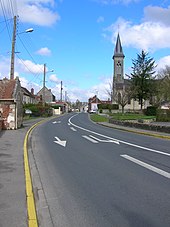
- Saint-Pierre-Saint-Paul Church
Web links
Commons : Montmacq - collection of images, videos and audio files

