
Vieux-Moulin (Oise)
| Vieux-Moulin | ||
|---|---|---|

|
|
|
| region | Hauts-de-France | |
| Department | Oise | |
| Arrondissement | Compiègne | |
| Canton | Compiègne-2 | |
| Community association | Région de Compiègne et de la Basse Automne | |
| Coordinates | 49 ° 24 ' N , 2 ° 56' E | |
| height | 35-130 m | |
| surface | 17.65 km 2 | |
| Residents | 644 (January 1, 2017) | |
| Population density | 36 inhabitants / km 2 | |
| Post Code | 60350 | |
| INSEE code | 60674 | |
| Website | http://www.vieux-moulin.fr/ | |
_mairie_2.JPG) Town hall (Mairie) of Vieux-Moulin |
||

Vieux-Moulin is a northern French municipality with 644 inhabitants (as of January 1 2017) in the department of Oise in the region of Hauts-de-France . It belongs to the Arrondissement Compiègne and the canton Compiègne-2 (until 2015: canton Compiègne-Sud-Est ). The inhabitants are called Vieux-Moulinois .
geography
Vieux-Moulin is located about nine kilometers east-southeast of Compiègne in the middle of the Compiègne forest . Vieux-Moulin is surrounded by the neighboring communities of Compiègne in the north and west, Trosly-Breuil in the east and northeast, Cuise-la-Motte in the east, Pierrefonds in the southeast and Saint-Jean-aux-Bois in the south and southwest.
Population development
| year | 1962 | 1968 | 1975 | 1982 | 1990 | 1999 | 2006 | 2013 |
|---|---|---|---|---|---|---|---|---|
| Residents | 505 | 426 | 409 | 418 | 495 | 579 | 628 | 626 |
| Source: Cassini and INSEE | ||||||||
Attractions
See also: List of Monuments historiques in Vieux-Moulin (Oise)
- Saint Mellon Church
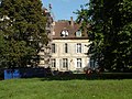
- Empress Eugénie's pavilion from 1857
- Coelestine priory in Saint-Pierre-des-Chastres
- Forward house of Saint-Pierre-des-Chastres
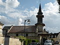
Saint Mellon Church

Empress Eugenie's pavilion

Coelestine Priory
Forester's house


Personalities
- Eugène Lefèvre-Pontalis (1862–1923), art historian and archaeologist