Golancourt
| Golancourt | ||
|---|---|---|

|
|
|
| region | Hauts-de-France | |
| Department | Oise | |
| Arrondissement | Compiègne | |
| Canton | Noyon | |
| Community association | Pays Noyonnais | |
| Coordinates | 49 ° 42 ' N , 3 ° 4' E | |
| height | 61-92 m | |
| surface | 4.13 km 2 | |
| Residents | 391 (January 1, 2017) | |
| Population density | 95 inhabitants / km 2 | |
| Post Code | 60640 | |
| INSEE code | 60278 | |
| Website | http://www.golancourt.fr.sitew.com/ | |
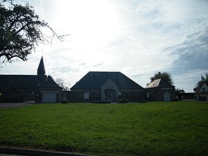
 View of Golancourt |
||
Golancourt is a French municipality with 391 inhabitants (as of January 1 2017) in the department of Oise in the region of Hauts-de-France (before 2016 Picardy ). It belongs to the canton of Noyon (until 2015 Guiscard ) and to the municipality association Pays Noyonnais .
geography
Golancourt is located in the Pays Noyonnais about 50 kilometers northeast of Compiègne . Golancourt is surrounded by the neighboring communities of Muille-Villette in the north, Brouchy in the east and northeast, Berlancourt in the southeast, Le Plessis-Patte-d'Oie in the south, Flavy-le-Meldeux in the southwest and Esmery-Hallon in the west and northwest.
Population development
| year | 1962 | 1968 | 1975 | 1982 | 1990 | 1999 | 2006 | 2013 |
|---|---|---|---|---|---|---|---|---|
| Residents | 300 | 317 | 332 | 364 | 418 | 404 | 406 | 371 |
| Source: Cassini and INSEE | ||||||||
Attractions
- Saint-Rémi Church (see also: List of Monuments historiques in Golancourt )
Web links
Commons : Golancourt - collection of images, videos and audio files
