
Rotary radio beacon


A rotary radio beacon (English abbreviation VOR [ ˌviːˌəʊˈɑː ] ) is a radio beacon for aviation navigation . It sends out a special radio signal from which a receiver in the aircraft can determine the direction to the radio beacon. The aircraft does not need a direction finding system for this, as the directional information is encoded into the signal by the transmitter.
The abbreviation VOR stands for V HF O mnidirectional R adio Range. VHF means V ery H igh F requency, the English name for the ultra-short wave (FM). Omnidirectional Radio Range means “all-round radio location” in German. The German term "VHF rotary radio beacon" for a VOR is hardly used in flying practice.
The actual VOR is the ground station, the signal of which can be evaluated by the VOR receiver in the aircraft and read as directional information on a display device. For the sake of simplicity, however, the recipient is also referred to as VOR.
Knowledge of navigation to VOR is required in the examination for the issue of an aircraft radio certificate.
Working principle
The special feature of the VOR compared to simple (non-directional) radio beacons is that the receiver “looks” at the received signal from which direction it is coming; it looks different from another direction. To show how this is technically achieved, first a small thought experiment:
Analogy to the lighthouse

The graphic on the right shows a lighthouse that emits the following light signals:
- a light signal of blue color that rotates clockwise as a strongly focused beam and
- a second, all-round emitting light signal of green color, which lights up briefly whenever the rotating blue beam points exactly north.
An observer at any position sees one green and one blue flash of light per revolution. The direction to the lighthouse results directly from their phase shift : If he sees them at the same time, he is standing north of the lighthouse; if he sees them alternately, he stands south.
This comparison is just a model to show how directional information is encoded into the signal. In the VOR, this principle is implemented in a technically more complex and precise manner with radio waves.
IN FRONT
The transmitter system generates a complex signal, consisting of:
- a directional component rotating at 30 revolutions per second. Due to the directional characteristics of the transmitting antenna, the VOR device in the aircraft receives a signal whose amplitude increases and decreases 30 times per second - a 30 Hz amplitude modulation ;
- an omnidirectional component, also modulated at 30 Hz (30 Hz frequency modulation of a 9960 Hz subcarrier);
- a Morse code;
- (optional) an audio channel. VOR transmitters in the vicinity of large commercial airports sometimes broadcast the current approach information (ATIS) for the airport.
The phase difference (0… 360 °) between the two 30 Hz modulations is measured in the receiver and displayed as a radial (azimuth angle 0… 360 °). The radial corresponds to i. d. R. the magnetic direction from the VOR station to the aircraft.
Example: If the aircraft is to the east (90 °) of the VOR, the phase difference between the directional and the non-directional signal is 90 °. The tip of the indicator needle of the radio compass (RMI R adio M agnetic I ndicator) points to the angle value 270 °, because the VOR is west. At a position west of the VOR (270 °) the phase difference is 270 °. The tip of the needle of the radio compass points to the angle value 90 °, because the VOR is to the east of the aircraft.
DVOR (Doppler VOR)
DVOR is an acronym for D Hoppler V ery High Frequency O mnidirectional R adio Range = Doppler VHF omnidirectional radio range. Such systems generate the same signal in a different technical way with greater precision.
In contrast to the conventional VOR, with the DVOR the 30 Hz AM component (amplitude modulation) is sent by a stationary omnidirectional antenna, now as a reference signal, while the 9960 Hz subcarrier is quickly switched between 50 antennas on a circle with 13, 5 m diameter are arranged, is radiated. This simulates an almost continuous counterclockwise circular movement of the subcarrier radiation center. In the receiver, the movement of the radiation center causes a 30 Hz frequency modulation with a frequency deviation of ± 480 Hz, the phase of which is direction-dependent (circular signal), due to the Doppler effect .
In the conventional VOR, the reference signal is broadcast as 30 Hz FM from a stationary antenna; the variable signal is generated as 30 Hz AM by a rotating directional antenna. In DVOR, the roles of the reference and variable signals are exactly the opposite: the reference signal is 30 Hz AM from a stationary omnidirectional antenna and the variable signal, 30 Hz FM, is generated by the Doppler effect of the surrounding radiation center. Because the reference signal and the variable signal of the DVOR are reversed compared to the conventional VOR, the signal on the circular group antenna runs counter-clockwise.
Compared to the conventional VOR, a DVOR transmitter achieves two to three times the accuracy: With DVOR, the radial error rarely exceeds a value of 1 °, while with normal VOR it can be up to 2.5 °.
Examples
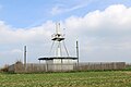
Standard VOR
Standard VOR are relatively small and only take up a few square meters on the floor. They can also be set up and operated temporarily as a mobile unit.

Standard-VOR TAI in the Taunus, which replaced the Doppler-VOR TAU 400 m to the northeast in autumn 2019

Container-VOR at the location of VOR SAS in Sarstedt
VORTAC Nattenheim (NTM). The top transmitter is the TACAN, a military system that works similarly but is more precise.


;_VORTAC_Nattenheim_NTM_b.jpg)
Doppler VOR
Doppler VOR are significantly larger and more complex than standard VOR, as they generate the rotating signal components via a ring of individually controlled antennas, which is also visually striking with its 13.5 m diameter. As a rule, they stand permanently on fenced-in properties of the order of 40 × 40 m. In most cases, the antenna system is completely mounted on an approximately 30 m large ground plane elevated by several meters in order to keep the effects of the terrain and vegetation on the radiation low.

DVOR Michaelsdorf (MIC)

Detailed view of the DVORTAC Dinkelsbühl (DKB) with the assembly and wiring of the antenna ring

Unusually tall DVOR at Yao Airport, Osaka, Japan


history
The first radio beacon was the Telefunken compass transmitter (1908). The transmitter began with the omnidirectional (undirected) transmission of its identifier. After receiving the last letter of the identifier, a special stop watch was started in the receiver and stopped again at the signal maximum.
In the further development it turned out to be advantageous to evaluate the minimum of the rotating signal, since it can be determined much more precisely than the signal maximum .
During the First World War in Western Europe there were stations in Tønder (then Germany), List on Sylt , Nordholz , Borkum and a station in Houtave in West Flanders , near Bruges in Flanders , Belgium . In addition to these directional transmission systems, there were two systems in Cleve and Tønder, which broadcast omnidirectional signals at intervals. All of these (rotating) radio beacons were used to navigate airships. Aircraft were not yet equipped with receivers for this system.
During the Second World War, highly developed German systems were built on the entire western front under the name Bernhard .
The first modern VOR systems were put into operation in Germany in the early 1950s. The basic network at that time consisted of eight stations.
According to the German Radio Navigation Plan (DFNP) of the Federal Ministry of Transport, Building and Urban Development (BMVBS), the VORs and DVORs have been successively dismantled since 2005. According to the German air traffic control, "for security and redundancy reasons" it is assumed that "we will continue to have at least one" backup network "of terrestrial infrastructure in the future."

Frequencies
The VOR ground station transmits on a frequency in the range of 108.00 MHz to 117.95 MHz (according to ICAO Annex 10) published in aeronautical charts and in the aeronautical manual . The channel spacing is 50 kHz, so the channels are 108.00, 108.05, 108.10… 117.95 MHz; however, the frequencies 108.10, 108.30, 108.50… 111.90 MHz and 108.15, 108.35, 108.55… 111.95 MHz are reserved for instrument landing system landing course transmitters .
Azimuth and radial

The VOR system, consisting of a ground transmitter and an on-board receiver, supplies information, namely the azimuth of the aircraft from the VOR transmitter, i.e. H. the angle between the (magnetic) meridian running through the ground station and the line connecting the ground station to the aircraft. VOR transmitters are i. d. Usually aligned so that the 360 ° radial points in the magnetic north direction ( magnetic ). VORs in the vicinity of the magnetic poles with high variation , however, are aligned with the geographic north pole (true).
A radio station line directed away from the VOR transmitter with a given azimuth is called a radial . There are 360 radials for the practice of flight navigation. Decimal places are not used, only whole numbers. A radial is thus a directed vector (but only with directional information, without size) with the direction away from the beacon. Because in contrast to a light beam from the lighthouse, our radio control line (e.g. R-040) also transmits beyond the center point in the opposite direction (i.e. direction 220 ° = 40 ° + 180 °). In this other direction, however, it is by definition referred to as R-220.
Like all course information and compass information, the directional information of the radial is always written and spoken in three digits. All three digits are pronounced individually. The words one hundred or ten, twenty, thirty, etc. are not used. Example: 40 ° is R-040 and is pronounced: Radial zero-four-zero. Radial 0 ° (i.e. north) is usually only referred to as R-360 (radial three-six-zero).
Positioning
An exact position determination is technically not possible with a VOR alone, since it only provides information about the radio position line on which the position is located. The exact position on this baseline must be determined separately, either by cross bearing or by a separate distance measurement to the VOR.
Cross bearing
With this method, a second VOR is targeted and its base line is determined. Your own position results from the intersection of the two base lines. The precision of this measurement is highest when the two base lines are at right angles to each other.
DME
A VOR is often also combined with a radio navigation system for distance measurement - the DME . In Germany, this is the case with around three quarters of all rotary radio beacons. DME ( D istance M easuring E quipment - distance measuring device) shows the distance to the DME transponder in nautical miles (NM). There is a second device for the DME display in the aircraft, the reception frequency of which is linked to the VOR receiver so that only the VOR frequency has to be set. If the set VOR has no DME, the DME unit in the aircraft remains without a display.
Rule of thumb
With a stopwatch, the distance to a VOR can be estimated as follows, even without a DME:
You turn on a course where the VOR is at 90 ° or 270 ° ( i.e. flies at right angles to the base line) and determines the time after which a certain course deviation occurs , for example 2 °. The distance to the VOR is then obtained using the small-angle approximation to ( in radians) or ( in degrees).


Appropriate shaping of the fraction results in the following sufficiently precise and manageable rule of thumb:

The result is to be interpreted depending on the unit of speed: speed in knots gives nautical miles, speed in km / h gives kilometers. For example, if you reach a 3 ° course deviation in half a minute at a speed of 80 knots, the distance to the VOR is approximately

That is less than five percent next to the geometrically calculated value of:

Cones of silence

When the aircraft is directly above the VOR station, the transmitted radio waves can be received, but the phase difference cannot be evaluated because the method is optimized for the horizontal plane. This silence cone (English cone of silence or cone of confusion ) also exists in the NDB and has an opening angle of approximately 10 °, thus having a diameter of about 1.5 for a commercial airliner in 15 km altitude nautical miles has.
Since the display of the VOR instrument in the silence cone is not reliable, a red warning flag is shown in the display field.
VOR names

VORs have a real name and a three-letter code. For example: Gardermoen-VOR or GRD (this is the international airport of Oslo / Norway). The three letters are i. d. R. derived from real names. The three letters are usually pronounced in the international aviation alphabet (ICAO alphabet) - i.e. Golf-Romeo-Delta. In flight radiotelephony, VOR is always simply said and not VOR / DME or VORTAC. If it is clear that it is a VOR, usually just the name is said - without the addition "VOR". Example: "cleared to Frankfurt via Nienburg and Warburg".
The name of Intersections is given as five letters to make them clearly distinguishable from VOR. Example: the route BUDDA-DERFA-VISLA-PRG-WERLA leads through exactly one VOR: the PRG-VOR.
Name duplications rarely occur, and then mostly only on different continents. So this only becomes an issue when you create flight routes from global databases of navigation systems. This is usually followed by an interim query in which the type and coordinates of the two radio systems of the same name are displayed. There are also name collisions with NDBs .
The name and the location where the VOR is located do not necessarily have to be the same. The VOR WIL ( Willisau ) in Switzerland is located a few municipalities further in Grossdietwil .
Map display

There are separate symbols for on aeronautical charts
- IN FRONT
- VOR with DME
- VORTAC
There is no distinction between VOR and DVOR.
In the compass roses around VORs on the aeronautical chart, the magnetic declination is already taken into account.


Ground facilities
Range; Categories of VORs
VORs are divided into three categories according to their range ( service volume ) in the USA, depending on how far the guaranteed, clear signal reception without interference extends.
- High Altitude VOR (HVOR) - maximum range 130 NM at 45,000 ft
- Low Altitude VOR (LVOR) - range 40 NM at 18,000 ft
- Terminal VOR (TVOR) - range 25 NM at 12,000 ft, is generally used as an approach aid.
Here follows the breakdown of the ranges according to the altitude.
- HVOR:
- 1,000 to 14,500 ft - 40 NM
- 14,500 to 18,000 ft - 100 NM
- 18,000 to 45,000 ft - 130 NM
- 45,000 to 60,000 ft - 100 NM
- LVOR: 1,000 to 18,000 ft - 40 NM
- TVOR: 1,000 to 12,000 ft - 25 NM
The ATIS can often be received from a TVOR station .
Container-VOR
If a VOR fails for a long period of time (e.g. conversion, renewal), DFS will set up a container VOR that will take over operation during the downtime. The container VOR is usually given its own frequency and therefore does not transmit on the frequency of the VOR to be replaced. The replacement frequency and the duration of the replacement as well as any restrictions in range and accuracy will be published by NOTAM .
Test-VOR (VOT)

The functionality of the VOR receivers must be checked at regular, prescribed intervals. On the one hand, this can be done more frequently at airfield positions whose coordinates are known. It can also be tested by setting the frequency of a test VOR on the VOR receiver. The VOR instrument then shows a constant Radial 360 and the measured deviation must not exceed 1 °.
For the VOT test, a signal is sent that shows 360 ° FROM (or 180 ° TO) on the receiver. The maximum deviation on the ground is ± 4 °. In the air, the deviation may not exceed ± 6 °. If there are two VOR receivers in the aircraft, the display difference between the two receivers must not exceed 4 °.
Combined ground facilities
VOR / DME
A VOR is often combined with a radio navigation system for distance measurement - the DME ( distance measuring equipment ) (around three quarters of all rotary radio beacons in Germany have DME). VOR indicates the direction from the ground station to the aircraft; DME shows the distance to the DME transponder in nautical miles (NM). The combination of VOR and DME enables position determination with the help of a single ground station.
VORTAC
TACAN (Tactical Air Navigation) is a military rotary radio beacon and works similarly to a VOR, but is more precise by a factor of 1.2 to 2. In addition, the DME functionality is always integrated in the TACAN signal. TACAN transmits in the UHF range (962 to 1213 MHz). If the VOR and TACAN ground station are in the same place, the combination is referred to as VORTAC.
On-board system
In addition to power supply and cabling, the on-board system consists of the following components. Depending on the installation situation, several modules can be combined in one housing.
Control unit
The frequency of the desired VOR ground station is set here. Some VOR devices offer the option of setting two frequencies: the currently active frequency and a preselected frequency (stand-by frequency). You can swap the two frequencies at the push of a button.
If the aircraft is equipped with ILS , this also sets the frequency of the glide slope transmitter (frequency band 329.15… 335.00 MHz).
If the aircraft is equipped with DME , i. d. Usually, the sending and receiving frequencies of the DME (frequency band 960… 1215 MHz) are set at the same time.
Display instrument
Different types of display devices can be used:
- Radio Magnetic Indicator (RMI). A pointer rotates on a compass map and points to the VOR ground station; the compass map, in turn, is rotated by the course gyro and shows the magnetic heading. The pilot can read both the magnetic bearing to the VOR ground station (QDM) and the relative bearing of the VOR ground station (left / right) on the RMI.
-
Course Deviation Indicator (CDI). Depending on the design, the indicator needle rotates around the topmost point, or moves it to the right or left by parallel displacement. The indicator needle points to a scale with a central point and 5 points each to the right and left. Each point corresponds to a deviation of 2 ° from the target course.
The desired course is set using the OBS (Omni Bearing Selector) knob.
Further displays (triangle upwards TO , triangle downwards FR (OM) ) indicate whether the aircraft is on a radial towards or away from the VOR. It has nothing to do with the actual direction of flight. A warning flag appears if reception is disturbed. - Cross pointer instrument . If the aircraft is equipped with ILS , a cross-pointer instrument is used instead of the CDI. The vertical needle (deflection left / right) has the same function as with the CDI. The horizontal needle (deflection up / down) shows the deviation from the glide path.
- Horizontal Situation Indicator (HSI). The HSI combines the function of the CDI with the course gyro display.
- Electronic Flight Instrument System (EFIS). Information from the VOR receiver can be shown in the navigation display of the EFIS. Often, traditional electromechanical instruments such as RMI and CDI are mimicked in the EFIS.


Rotary radio beacons are very useful in densely populated countries with flat landscapes because of their limited range. In narrow valleys, VORs are unsuitable because of the strong reflection of VHF signals on the mountains, where you have to rely on NDBs , such as at Innsbruck Airport .
For cost reasons, the convenient but expensive VOR navigation is reserved for highly developed countries; in sparsely populated (developing) countries, NDBs are indispensable for flight navigation. Islands like Tuvalu cannot be found without an NDB, there will probably not be a VOR there in the future either.
Global Navigation Satellite Systems (GNSS) are gradually displacing VOR / DME. In Germany, VOR / DME are still the primary instruments required by law for instrument navigation.
Airways
Airways were originally mainly guided by radio navigation systems, including VOR radio beacons, and their course was defined by these. The branching of airways often took place at VORs. Since the introduction of area navigation ( RNAV ), airways and reporting points (intersections) have been increasingly defined independently of ground-based radio navigation systems such as VORs, which significantly increases the capacity of the airspace.
The connecting line between two radio beacons (VOR, NDB, etc.) necessarily results in a course due to their unchangeable position, which is also called the OBS course. This course can be found on the flight map next to the airway; it should not be confused with the radial of the VOR (for example R-345), which shows the opposite course (± 180 °) to the actual course.
If you move towards a radio beacon on an airway, this is called “inbound”, if you move away from it, it is called “outbound”.
List of VORs in Germany

List of VORs in Austria

| |||||||||||
Locations of all 11 VORs in Austria |
List of VORs in Switzerland

| Identifier | Type | Surname | Frequency / channel | Coordinates | location | |
|---|---|---|---|---|---|---|
| BLM | DVOR / DME | Basel / Mulhouse | 117.45 | 47 ° 37 '58.00 " N , 007 ° 29' 58.00" O | Near Bartenheim; on French territory, as Basel Mulhouse Freiburg Airport is operated jointly by two countries | |
| FRI | VOR / DME | Friborg | 110.85 | 46 ° 46 ′ 42.00 ″ N , 007 ° 13 ′ 24.00 ″ E | Between Sankt Ursen and Rechthalten, Canton of Friborg | |
| GRE | DVOR / DME | Grenchen | 115.45 | 47 ° 10 '59.00 " N , 007 ° 25' 05.00" O | at Grenchen Airport | |
| GVA | DVOR / DME | Geneva | 115.75 | 46 ° 15 '14.00 " N , 006 ° 07' 56.00" O | at Geneva Airport | |
| HOC | DVOR / DME | High forest | 113.2 | 47 ° 28 '00.00 " N , 007 ° 39' 54.00" O | near Gempen, Canton Solothurn | Repealed since 2016 |
| LOO | DVOR / DME | Balls | 114.85 | 47 ° 27 '42.00 " N , 008 ° 33' 00.00" O | at Zurich Airport | |
| MOT | DVOR / DME | Montana | 115.85 | 46 ° 18 ′ 48.00 ″ N , 007 ° 30 ′ 12.00 ″ E | 16 km northeast of Sion Airport | Repealed since 2012 |
| PAS | DVOR / DME | Passeiry | 116.6 | 46 ° 09 '48.00 " N , 006 ° 00' 06.00" O | Municipality of Chancy, in the far west of Switzerland | |
| SIO | DVOR / DME | Sion | 112.15 | 46 ° 12 ′ 54.00 ″ N , 007 ° 17 ′ 18.00 ″ E | 3 km west of Sion Airport | |
| SPR | VOR / DME | St-Prex | 113.9 | 46 ° 28 ′ 07.00 ″ N , 006 ° 26 ′ 53.00 ″ E | in Lake Geneva approx. 1 km south of Saint-Prex | |
| TRA | DVOR / DME | Trasadingen | 114.3 | 47 ° 41 ′ 22.00 ″ N , 008 ° 26 ′ 13.00 ″ E | 27 km NNW from Zurich Airport | |
| WIL | VOR / DME | Willisau | 116.9 | 47 ° 10 ′ 42.00 ″ N , 007 ° 54 ′ 21.40 ″ E | near Grossdietwil, Canton Lucerne | |
| ZUE | DVOR / DME | Zurich East | 110.05 | 47 ° 35 '32.00 " N , 008 ° 49' 03.00" O | 25 km northeast of Zurich Airport |
See also
- RSBN (Russian rotary radio beacon system with a similar principle)
Web links
- techn. Details of VOR and DVOR - radio navigation method: Navtec (PDF; 88 kB)
- VOR - simulation for training for radio navigation
- Arthur O. Bauer: Some historical and technical aspects of radio navigation in Germany over the period 1907 to 1945; Diemen (NL), 2004 (PDF; 1.03 MB)
- Radio telegraphy and direction finder radio in German war aviation
Individual evidence
- ↑ Example: Exam questions on BZF I and II, from page 46 , PDF from the Federal Network Agency, accessed on July 2, 2020
- ^ Beacon in Tuvalu
- ↑ https://www.dfs.de/dfs_homepage/de/Services/Customer%20Relations/Kundenbereich%20IFR/29.05.2019%20-%20Planung%20ILS-NAV-Infektur%202019-20/ILS-NAV-Planung% 202% 20Hj% 202019% 20u.% 20Outlook% 202020.pdf