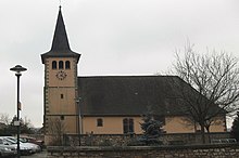
Rauwiller
| Rauwiller | ||
|---|---|---|

|
|
|
| region | Grand Est | |
| Department | Bas-Rhin | |
| Arrondissement | Saverne | |
| Canton | Ingwiller | |
| Community association | Alsace Bossue | |
| Coordinates | 48 ° 49 ' N , 7 ° 6' E | |
| height | 275-332 m | |
| surface | 4.89 km 2 | |
| Residents | 209 (January 1, 2017) | |
| Population density | 43 inhabitants / km 2 | |
| Post Code | 67320 | |
| INSEE code | 67386 | |
Rauwiller ( German : Rauweiler ) is a French commune with 209 inhabitants (as of January 1, 2017) in Crooked Alsace in the Bas-Rhin department in the Grand Est region (until 2015 Alsace ). It belongs to the Arrondissement of Saverne .
geography
The village is located near the border with the Moselle department . The Autoroute A4 ( Autoroute de l'Est ) runs a few kilometers to the east . After Saverne in the east is about 25 km, Strasbourg in the southeast is about 70 km away.
history
The place is first mentioned as Rugwiller in 1288, in a document from 1344 it is called Ruwiller . In the 15th century the place was deserted and in 1599 it was settled again by Huguenot refugees. During the Thirty Years' War the place was badly destroyed by imperial troops. From 1871 until the end of the First World War , Rauwiller belonged to the German Empire as part of the realm of Alsace-Lorraine and was assigned to the district of Zabern in the district of Lower Alsace . In autumn 1944 the place suffered from devastation in the course of the fighting to liberate France towards the end of the Second World War .
Population development
| year | 1910 | 1962 | 1968 | 1975 | 1982 | 1990 | 1999 | 2007 | 2017 |
| Residents | 422 | 191 | 216 | 222 | 189 | 178 | 187 | 212 | 209 |
literature
- Le Patrimoine des Communes du Bas-Rhin . Flohic Editions, Volume 1, Charenton-le-Pont 1999, ISBN 2-84234-055-8 , pp. 336-337.
Web links
- Rauwiller at the Communauté de communes d'Alsace Bossue (French)

