
Hettstedt
| coat of arms | Germany map | |
|---|---|---|

|
Coordinates: 51 ° 39 ' N , 11 ° 31' E |
|
| Basic data | ||
| State : | Saxony-Anhalt | |
| County : | Mansfeld-Südharz | |
| Height : | 200 m above sea level NHN | |
| Area : | 36.93 km 2 | |
| Residents: | 13,885 (Dec. 31, 2019) | |
| Population density : | 376 inhabitants per km 2 | |
| Postal code : | 06333 | |
| Area code : | 03476 | |
| License plate : | MSH, EIL, HET, ML, SGH | |
| Community key : | 15 0 87 220 | |
| LOCODE : | DE HTD | |
City administration address : |
Market 1–3 06333 Hettstedt |
|
| Website : | ||
| Mayor : | Dirk Fuhlert ( FBM ) | |
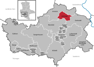
| Location of the city of Hettstedt in the district of Mansfeld-Südharz | ||
  |
||

Hettstedt is a town in the eastern Harz foreland in the district of Mansfeld-Südharz , Saxony-Anhalt , about 40 km northwest of Halle (Saale) . The city is known for earlier copper mining and non-ferrous metallurgy that is still important today.
geography

Hettstedt is located in the Federal Republic of Germany in the state of Saxony-Anhalt , about 50 km south of the state capital Magdeburg and about 40 km northwest of Halle (Saale) . Hettstedt is located on the south-eastern edge of the Harz on the Wipper .
geomorphology
Hettstedt is located on the border of the Lower Harz and Harz foreland. The old town of Hettstedt lies in the valley of the Wipper, other parts of the city extend onto the valley slopes and the surrounding plateau. The plateau is the raised clod of the Lower Harz Mountains, into which the Wipper and its tributaries cut deeply. This means that the hills - in contrast to mountains and hills in the real sense - do not drop significantly on at least one side, but merge into the hilly plateau of the Lower Harz. The relatively large height differences give the urban area a mountainous character.
- The lowest point in town : the Wipper river bed near the sports field on the Silbergrund +139 m
- Highest point in the city : South-western part of the “Mansfelder Land” techno and industrial park +244 m
geology
Hettstedt is located on the prominent Harz floe on the northeastern edge of the Mansfeld basin. Under a layer of sandstone and limestone lies a layer of copper-containing claystone known as copper shale . Under this layer lies another layer of limestone and / or very fine-grained sandstone, red-colored by iron oxide, known as the red lying . Both rocks are partially mixed as a conglomerate . This sequence of layers emerges to the north and west of Hettstedt to the surface and drops to greater depths to the southeast.
The valley of the Wipper cuts through this sequence of layers. Thus the copper slate comes to the surface three times near Hettstedt: north and west of the city as the layers run out, and on the western and eastern slopes of the Wipper valley. The valley floor of the Wippertal is formed by river sediments .
Neighboring communities

Neighboring communities are Arnstein in the north, Gerbstedt in the southeast and Mansfeld in the southwest.
City structure


The unified community consists of the core town of Hettstedt and the localities of Ritterode and Walbeck (both incorporated on September 1, 2010).
| Locality | Residents | Districts |
  |
|---|---|---|---|
| Hettstedt | 14,427 | see below | |
| Ritterode | 320 | Ritterode and Meisberg | |
| Walbeck | 882 | Walbeck |
Districts
- Old town
Located on the western bank of the Wipper. The Jacobi Church, the market square, the Brückor (code cart), the Sugar Loaf or Witches Tower, the Saigertor and the Freimarkt are located here. The district consists mainly of older two to three-story buildings. The buildings on Markt and Freimarkt have often been restored and have shops on the ground floor. To the north of the old town there is an outdoor swimming pool and numerous allotment gardens in the Wipper valley . The former Saigerhütte follows even further north in the Wipper valley . The area is named Silbergrund with reference to the earlier silver production in the Saigerhütte. The Saigertor, the town's landmark, got its name according to a theory from its orientation towards the Saigerhütte.
- Copper mountain
Located east of the old town and the Wipper on the eastern slope of the valley. In this part of the village lies the Gangolf Church, which, according to legend, was built where the first copper was found. The relatively small chapel is the oldest church in the region. Until 1879, Kupferberg was a separate village and was then incorporated into the municipality. The Kupferberg belongs to the old town area, which mainly consists of older residential buildings. The closer you get to the eastern outskirts, the younger the development tends to be. There are allotment gardens on the south-eastern edge of the district.
- Molmeck
Located southwest of the old town in the Wipper valley and on the western slope of the valley. The district consists mainly of one to two-story residential buildings that date from before the Second World War . The south-eastern part of Molmeck in the Großörner district is bordered by a large industrial area that houses the remaining parts of heavy industry.
- Burgörner-Neudorf
Located southeast of the old town and east of the Wipper in the valley and on the eastern slopes of the valley. The train station and the clubhouse, an event building with a swimming pool, are located in this district. The district consists mainly of one to two-story residential buildings that date from before the Second World War.
- Burgörner-Altdorf
Located southeast of the old town and east of the Wipper in the valley and on the eastern slopes of the valley. The Mansfeld Museum and the Machine Monument are located in this district . The district consists mainly of one to two-story residential buildings that date from before the Second World War. To the south-east of the district is an overburden dump from the late 19th century with an area of around 200,000 m².
- Vineyard
Located west of the old town on a hill. Among other things, the municipal cemetery is located here. The district consists mainly of single-family houses, with age tending to decrease towards the outskirts. To the west of the Weinberg district, on the outskirts of the city, is the industrial park Ritteröder Straße.
- 1. Residential complex
Located northwest of the old town and south of the B 180 on a hill. Also called 1. WK (“First WeKa”) for short. In this part of the village there is, among other things, the fairground with the flame of friendship. The district consists mainly of standardized, three-story apartment buildings with a pointed roof from the 1950s. The streets in this area of the district are mainly named after writers. Single-family houses are connected to the west, and an allotment garden section further west. The northwest to the first residential complex closes techno and industrial park "Mansfeld" on.
- 2. Residential complex
Located north of the 1st residential complex and the B 180 on a hill. The second residential complex is also called 2nd WK ("Second WeKa") for short. The district consists mainly of standardized, four-story apartment buildings with a pointed roof from the 1950s and 1960s. On the eastern edge of the district is the Scheuberg, a terrain spur that protrudes into the Wipper valley and is also built with apartment blocks. The streets in the district are mainly named after writers.
- 3. Residential complex
Located northeast of the 2nd residential complex on a hill. The 3rd residential complex is also called 3rd WK ("third WeKa") for short. The district is separated from the second residential complex by a small forest, the Walzwerkhölzchen. The district forms the northern outskirts of Hettstedt and in places borders directly on the neighboring municipality of Wiederstedt. It mainly consists of the WBS-70 panel structures typical of East Germany . This was built at the beginning of the 1980s. Since the end of the 1990s, almost every second prefabricated building has been demolished due to the high vacancy rate. The streets in the OT are named after composers, which earned him the nickname "Musikantenviertel".
- 4. Residential complex
Located northwest of the 2nd residential complex on a hill. The fourth residential complex is also known as the 4th WK ("Vierter WeKa") for short. Like the 3rd residential complex, it mainly consists of WBS-70 panel buildings. The construction of the apartment blocks began in the late 1980s and was only completed after the fall of the Wall. The Kolping Vocational Training Center and the Mansfelder Land Clinic are located on the northeastern edge of the district and the city . Single-family house settlements were created both in the immediate vicinity of the clinic and on the northeastern edge of the district. The streets in the OT were named after tree species, in the northeastern single-family housing estate after flowers, in the single-family housing estate near the clinic after doctors and biologists.
Recreation areas
- Walbeck Zoo
The Walbeck Zoo is located in the north-east of Walbeck in the wooded valley of the Walbke . Since 1965, visitors there have had the opportunity to see native animals up close. More than 26 species of animals live in naturally designed outdoor enclosures.
- Recreation area Ölgrundteich
Located northeast of the 3rd and north of the 4th residential complex. The local recreation area is part of a forest area of around 150 hectares, which extends westward along the valley of the Walbke brook to Walbeck. In the area lies the artificially created, approximately 3 hectare large oil pond , which is fed by the Walbke. From there you can take relaxing walks and short hikes. A sports center with 2 football stadiums, four tennis courts and a riding arena forms the transition to the third residential complex.
- Hadeborn Valley
Coming from Ritterode and Meisberg, it extends from the west to the old town. The Hadebornbach flows in the valley and flows into the Wipper near the Saigertor. In the old town area, the stream flows under Hadebornstrasse through a pipeline system. Close to the old town, the valley is dominated by dense development with two-story residential buildings, which, however, become looser up the valley and merge into single-family houses with large gardens. There are numerous allotment gardens on the northern slope of the valley and in the valley itself . The valley ends abruptly on the outskirts, as it has been filled in over a length of around 300 meters by a landfill. The Hadebornbach passes under the landfill in a tunnel. The landfill is now closed and is currently being renatured.
- Tone hole
Located near Burgörner-Neudorf on the south-eastern outskirts. The clay hole is a former pit in which clay was extracted, which was used as raw material for the nearby and now closed brickworks. Today the clay hole is a pond about 1 hectare in size with trees growing on its banks. The nearby spoil heaps offer a good view.
climate

Due to its sheltered location on the eastern edge of the Harz Mountains, Hettstedt is in the wind and rain shadow of this low mountain range. The average annual precipitation of 504.1 mm is far below the German average (800 mm / year). This means that the climate is significantly drier than the average for all regions in Germany (see picture description). The summer months are the wettest months, with the maximum of 62.7 mm being reached in June. Hettstedt is in the transition area from the maritime to the continental climate and is assigned to the subcontinental climate. Compared to other German cities, the local climate shows above-average temperature fluctuations between summer and winter months.
history
Beginnings of the place (1046–1199)
Hettstedt was built at a ford over the Wipper. The time of the first settlement is not known. 1046 Hettstedt was in a deed of gift from Heinrich III. first mentioned to the diocese of Meißen as "Lokus" (village, place, market town) called Heichstete. Name researchers assume that the name refers to the first name Heiko or Heco. This could have been the name of a local resident, whereupon the place was called "Heiko's place". In 1181 the place was destroyed by Heinrich the Lion (of Braunschweig).
First bloom through mining (1199–1560)
According to legend, the brothers Napian and Neucke 1199 found in Hettstedt copper . Significant amounts of silver were also produced during its extraction . Although copper dominated in terms of quantity, silver initially represented the main part of production in terms of value. In 1223 the place was first mentioned as a village and in 1283 as a city. Due to the lucrative copper and silver mining and smelting , the population of the place grew rapidly due to immigration. In 1334 city rights were granted. In 1341 the Bishop of Halberstadt conquered Hettstedt in a War of Succession with Count von Regenstein and in 1394 he pledged the castle for 4400 guilders to the Count of Mansfeld. From 1430 to 1439 the city received a city wall with three gates: Saigertor to the north, the bridge gate over the Wipper to the east and the Molmeck gate to the southwest. After the citizens of the city had occupied the moated castle, the city was besieged and conquered in 1439 by the Count of Mansfeld and his allies. Hettstedt subsequently became part of the County of Mansfeld and experienced a decade of decline. The city's upswing began again from 1450 through the granting of some privileges and the introduction of the Saiger process . The silver could now be separated from the copper with less effort. Hettstedt also benefited as a market place where grain and cattle from the Magdeburg Börde and the Saale region were handled for the miners in the region.

Economic decline (1560-1644)
A lack of wood as a result of the increasing deforestation of the Harz Mountains, increasing problems with the groundwater in the ever deeper shafts and the fall in silver prices due to silver imports from the Spanish colonies in South America caused a decline in production from around 1560. In 1573 the city came back under the Saxon upper fiefdom as a debt service, but the mining remained formally under the control of the Counts of Mansfeld. Around 1600 the city had a little over 2,000 inhabitants. In the Thirty Years War , mining came to a standstill for the time being. Due to acts of war, famine and the outbreak of the plague, the population of the city fell to around 500 by 1644, with only eleven houses remaining.
Economic recovery (1644–1785)
With the construction of new drainage tunnels using gunpowder , mining slowly got going again after the Thirty Years War, and the population of Hettstedt rose again as a result. Due to the fall in the price of silver, copper was now the main product of the mining and metallurgical industries in terms of value. Due to the increasing depth of the tunnels, however, water uplift became an ever greater problem, which slowed down economic development. With the death of the last male Mansfeld Count Josef Wenzel Nepomuk von Mansfeld-Vorderort-Bornstedt, Hettstedt fell back to the feudal lords, mining in the area around the city to Prussia in 1780 , while Saxony initially took over direct control of the city.

Industrialization and second bloom (1785–1929)
In 1785, a steam engine from Watten was built to drain the tunnels near Hettstedt , the construction plans of which were acquired by industrial espionage from Boulton & Watt . Thus Hettstedt became the location of the first Wattsch steam engine in Prussia. Due to the increasing use of steam engines, mining could be expanded dramatically in the following decades. By 1790, Hettstedt had a population of 2,900 again. After the Napoleonic Wars , the city of Hettstedt became part of the Prussian province of Saxony in 1815 . In the following 120 years, Hettstedt developed into an important heavy industry location on the basis of mining and copper smelting . It emerged alongside copper smelters and engineering, among others, a plant for the production of sulfuric acid from sulfur-containing exhaust gases of the huts (around 1850), a steel - mill (1908), a copper and brass factory (1909) and an aluminum plant (1935-36). Mining and heavy industry caused considerable environmental pollution in the city, mainly through the release of heavy metals, dust and sulfur compounds from the smelting of the sulfur-containing copper shale.
Subsidized continuation 1929–1989
Since the Great Depression in 1929, copper mining was no longer profitable, and state subsidies were still paid in the Weimar Republic to prevent mass layoffs. The subsidies were maintained and steadily increased both in the “ Third Reich ” and in the GDR due to the drive for self-sufficiency and a lack of foreign currency .
Despite the concentration of war-important industrial companies, the city was only attacked once by US bombers on April 11, 1945 during World War II . No industrial facilities were hit, but bombs in the old town killed 51 citizens and destroyed 30 buildings with 109 apartments, and a further 117 buildings were damaged. American troops occupied the city a few days later, but withdrew a few weeks later , according to the Yalta Declaration . Soviet troops occupied the area that became part of the Soviet occupation zone and later the German Democratic Republic (GDR).
On July 1, 1950, the previously independent municipality of Burgörner was incorporated. In 1952 the city became the district town of the newly founded district of Hettstedt. Large housing estates were built in the north of the city. Mining and large parts of heavy industry and mechanical engineering in the region were combined to form the Mansfeld combine, one of the largest combines in the GDR. After the local deposits were increasingly depleted, mining relocated to the Sangerhausen region , approx. 20 km away, between 1951 and 1969 , which triggered a lively commuter traffic among the Hettstedt miners. Heavy industry and mechanical engineering remained in Hettstedt, but hardly any investments were made in the facilities in the GDR , so that some machines from 1908 were used until 1989. Attempts were made to reduce the still serious environmental pollution in the city, but due to a lack of capital, little success was achieved. As a result of the incorporation, immigration and the birth surplus, the population rose to 16,316 by 1950, and again to over 21,000 by 1989.
The difficult new beginning (1989 to today)
At the end of the 1980s, the production costs of Mansfeld copper were around ten times the world market price for copper. After the German reunification , no more subsidies were paid, whereupon the mining was stopped. The industrial plants of the Mansfeld combine were for the most part outdated, so that they too were shut down due to a lack of profitability. After no investor was found for the entire company operating under the name "Mansfeld AG", it was divided into several parts from 1993 onwards. The search for investors was unsuccessful in some cases, other parts of the company changed hands several times, which caused uncertainty among the population. Within a few years, the number of people employed in industry fell to less than a quarter. This was one of the main reasons why Hettstedt had and still has one of the highest unemployment rates in Germany for years.
Today the remaining local industry has stabilized. The environmental impact of industry has decreased significantly. The water quality of the Wipper is now so good that it is populated in the urban area by ducks, fish and nutrias . The air quality has also improved significantly despite the increasing pollution from car exhaust fumes. However, there is still heavy soil pollution by heavy metals, especially in the area of the spoil heaps and the former steelworks. In this area, Hettstedt and the surrounding area have become a test field for soil remediation, for example using genetically modified plants.
The city lost in 1994 after merging of county Hettstedt and county Eisleben to Mansfeld county land their status as county seat to the Eisleben . Due to strong emigration and falling birth rates, the population fell below 15,000 inhabitants by 2008. As a result of the incorporation of the neighboring communities of Walbeck and Ritterode on September 1, 2010, the population rose again to 15,343.
Population development

After a low point after the Thirty Years' War, the population of Hettstedt rose sharply over the centuries until 1989. After the fall of the Berlin Wall, the population began to decline sharply and continue to do so. The number of inhabitants had declined by a quarter of the value in 1989 by 2010.
|
|
|

Religions
The religious community with the largest number of members in the city is the Evangelical Lutheran Church . There is also a Catholic community.
politics
City council
After the last local election on May 26, 2019 , the following parliamentary groups were formed in the city council: (As of September 2019)
| fraction | Seats |
| CDU , BSH, fire brigade | 9 |
| The left | 9 |
| FBM | 4th |
| AFD | 3 |
| SPD | 2 |
mayor
- In November 2011, Danny Kavalier (CDU) was elected to succeed Jürgen Lautenfeld in the first ballot. After Kavalier's death on the night of September 1, 2018, the office of mayor was initially vacant. In October 2018, Dirk Fuhlert (independent) was elected mayor.
Incorporations
- 1879 : Kupferberg
- 1950 : Burgörner
- 2010 : Walbeck and Ritterode
coat of arms
Blazon : "In silver a nimbly black-bearded man in natural colors, dressed in a gold robe with a black belt and a right-hand belt pouch with a silver shell, a green overcoat and a pilgrim's hat decorated with a silver shell, black sandals and a black pilgrim's staff in the crook of the right arm, each holding a coat of arms in the outstretched hands, on the right seven times divided by silver and red, on the left silver quartered, one and four six times divided by silver and red, in two and three two touching red diamond bars of three diamonds each. "
The nimbly man is Saint James the Elder , the church patron, with the Querfurt coat of arms in the right hand and the coat of arms (before 1481) of the Counts of Mansfeld-Querfurt in the left hand. The coat of arms was designed by the municipal heraldist Jörg Mantzsch based on a historical template .
Town twinning
- Voehringen , Bavaria
- Bergkamen , North Rhine-Westphalia (friendship between cities)
Culture and sights
Museums

- Mansfeld Museum in Humboldt Castle
Located in the district of Burgörner, this museum offers an insight into the history of the Mansfeld copper slate mining. Erected at a historic site - the Humboldt Castle - one can gain insights into the social and technical development of copper ore mining and the metallurgy of this region in a large open space. One attraction is the true-to-original replica of the first German steam engine built from German material and built by German workers and engineers.
A steam-powered museum railway is operated on part of the formerly extensive network of mining railways in the Mansfelder Land .
Buildings

Saigertor
The Saigertor is the northern gate of the city. It opens the way to Freimarkt, to Wiederstedt and Aschersleben. The gate is considered a landmark of the city, it dominates with its appearance over the rear part of the market place. The Saigertor was built in 1535 and got its name from the Mansfeld expression for clock "colander". It was destroyed in a fire on March 25, 1651 and rebuilt in 1721 and 1722. It is unmistakable thanks to the Welsche dome , which was adjusted to the dome of the church tower of St. Jakobi to unify the cityscape. When it was rebuilt, the tower was given a striking clock that had a non-striking predecessor as early as 1627. The tower is provided with arched curtain windows in frame framing, four Mansfeld coats of arms were attached to its north side, the year 1537 was immortalized above and below, with the inscription "verbvm domini manet in eternvm" next to it. Before the city's 950th anniversary celebrations, the Saigertor was restored and now shines again in its old splendor.
Coordinates: 51 ° 38 ′ 48.8 " N , 11 ° 30 ′ 49.5" E
Sugar Loaf Tower / Hexenturm
Defense tower of the former city fortifications. The Sugar Loaf is located on the most heavily fortified east side of the city wall. The tower was built in 1434, it takes its name from the wedge-shaped tower that served as a back protection for the defenders of the city. In the Middle Ages, people believed that the witches were locked up in this tower, hence the alternative name as the witch's tower. A witch was never locked in this tower, because it was not until the second half of the 18th century that a two-storey residential and prison building was added to the tower made from the remains of the city wall, which was used as a prison until the 1930s. A battlements led from the Saiger Gate to the Sugar Loaf so that it could be occupied as quickly as possible in the event of an attack. Today there is a gallery in the Sugar Loaf called the Artificial Sugar Loaf, which made it possible to restore the Sugar Loaf, which was in a catastrophic state until a few years ago. Exhibitions and workshops take place there regularly.
Coordinates: 51 ° 38 ′ 46 " N , 11 ° 30 ′ 50.5" E

Sugar Loaf Tower

Bridge gate


Bridge gate / code cart
The easternmost entrance to the city was the bridge gate, it was built around 1556. At that time, a wooden drawbridge was built over the Wipper, the simple water gate was demolished and reinforced with a gate tower. It owes the name bridge gate to the fact that it is the only gate that has a bridge. But it is also called “code cart”, the name probably comes from the time of the French occupation. Because in 1810 a company of French grenadiers was stationed as a guard in the bridge gate. Since then it has been called "Corps de Garde" or simply "French Tower". In 1716 the wooden bridge was torn down and replaced by a stone one, an inscription on the bridge still testifies to it.
Coordinates: 51 ° 38 ′ 43 " N , 11 ° 30 ′ 47.6" E
Molmeck Gate
The Molmecker Tor opens the way to Meisberg and the suburb of Molmeck. The gate, built in 1434, does not get its name from the former village of Molmeck, but it is more likely that the name comes from its builder. According to legend, the grain dealer Jacob Molmiß is said to have driven up the prices for grain so that hardly anyone could still afford grain. The citizens of Hettstedt joined forces and, as a punishment, forced Molmiß to bear the costs of the Molmecker Gate. During the construction period, Molmiß began to raise prices again, so the citizens locked him in his own tower. Trying to escape, he got caught on a ledge, starved to death, and turned to stone. In fact, a stone figure is attached to the tower that was once used as a prison. This figure is a gargoyle mounted on an ornate corbel. The figure of a man forms the last piece of the stone and is placed so that it carries the gargoyle on its back.
Coordinates: 51 ° 38 ′ 42.2 " N , 11 ° 30 ′ 40" E
Saint Gangolf Church

In 1199 the miners Nappian and Neucke discovered the copper shale ore on the copper mountain near Hettstedt. Since many people came there to look for ore as a result of this discovery, it became necessary to build a chapel. According to the legend, two oaks were felled and sawn on the Kupferberg in order to build a simple wooden chapel with a small cross on its top. This first place of worship on the Kupferberg, a Marienkapelle, became too small and demolished with the strong increase in the population. A small church was built from coal and slate.
At that time, Hettstedt and its surroundings were still under the rule of the Counts of Arnstein . The counts had donated a hospital in their ancestral seat in Arnstedt , but it had been destroyed by wars. Around 1204, Count Albrecht I von Arnstein (1175–1235 / 36) decided to move the Arnstedter Hospital to the Kupferberg. The hospital was connected to the existing Lady Chapel. In 1223, according to the document issued by Count Albrecht I von Arnstein, the chapel was removed from the parish area of St. Georg in the presence of Count Albrecht I von Arnstein and the Hettstedt pastor Heinrich von Drohndorf. Since then the chapel has served as a hospital church and has its own pastor. The hospital was dedicated to Saint Gangolf. There was constant unrest in the hospital as people were illegally admitted who were not in need. In 1254, the widow of Albrecht I von Arnstein, Mechthild von Arnstein (1196–1264) took advantage of this unrest. Together with her relative, Lucardis von Wernigerode, she founded a women's monastery association on the Kupferberg that belonged to the Augustinian women. In 1259 the monastery was moved to Oberwiederstedt . The vacant buildings on the Kupferberg were used as a farm yard, the ruins of which could still be seen until 1812.
Around 1400, the Romanesque chapel of St. Maria was converted into the Gothic village church of St. Gangolf. A vestibule was added to the west of the building and Gothic pointed arched windows replaced the Romanesque arched windows. In 1879 the Kupferberg was incorporated into Hettstedt, in 1884/86 the Kupferberg also came to Hettstedt as a church.
Coordinates: 51 ° 38 ′ 43.3 " N , 11 ° 30 ′ 53.7" E
Saint Jacobi Church

The St. Jakobi Church is the second church in Hettstedt. Its predecessor was a simple wooden church whose patron was St. George. St. George was the main lord , who was surely replaced bit by bit by the co- lord , St. James the Elder. A pastor was named at this church as early as 1223 in the document with which the copper mountain was released from the Hettstedts parish. According to a document from 1436, the St. Jakobi Church was a daughter church of the St. Eustachius Church in what is now the desert of Wesenstedt. The Abbess of the Servatiusstiftes in Quedlinburg had the patronage right. Since when is unknown, but it can be assumed that she had the right of patronage since the beginning of the church, because as early as 1351 Bishop Albrecht II of Halberstadt (1325-1358) announced that “dat husz and de stad to Hestede and all dat dar to gehort [Molmeck and Wesenstedt] “were possessions of the Servatiusstift. A few years later, the Abbess of Quedlinburg appointed a new pastor for Hettstedt, because she was entitled to the right of patronage. In 1434 the St. Jakobi Church incorporated its mother church St. Eustachius, because in the then almost desert Wesenstedt no more people lived. The union took place with the consent of Abbess Kunigunde von Walbeck . This can be explained by the fact that the farmers from Wesenstedt settled near Hettstedt in order to find greater protection there. Due to this increase in population, Hettstedt needed a larger church, the construction of which had already started in 1418. First the choir was built and completed in 1429 and the nave in 1445. The fact that it took so long to begin with the ship can be explained by the cost and time invested in the construction of the tower, which began in 1428 and on which the spire was added on July 27, 1475; the vault of the nave was not closed until 1517.
In the great fire of 1697, in which only 27 houses were spared, the St. Jakobi Church also burned. Since the church tower burned out internally, the bells melted, but the walls of the church remained standing so that they are still preserved today. The restoration of the church continued until 1706. During the renovation of the church in 1905, the two corner turrets on the east side of the tower were removed; these had previously served the turrets as apartments. A new tower clock was also installed.
Coordinates: 51 ° 38 ′ 43.3 " N , 11 ° 30 ′ 41.4" E
town hall


The oldest town hall of Hettstedt, mentioned in 1428, stood in the middle of today's market, where the monument square is. In the first big fire in the city in 1506, the town hall and the adjacent row of houses were destroyed. In 1520 the rear part of the town hall was rebuilt, and the front part followed in 1526. The shape of the second town hall is similar to today's one, but it was smaller. After being destroyed in the Thirty Years War, it was only poorly repaired in 1667 and a new bell tower was added in 1684. The town hall remained in this form until 1879. When it had become dilapidated, the town decided to build a new town hall. The third town hall was built in the neo-classical style, small corner turrets were added and stepped gables were built. A council cellar was set up on the ground floor. In 1913 this was also replaced by a new town hall. The fourth town hall in Hettstedt's history has, just like its predecessor, a restaurant on the ground floor, the Ratskeller, but in recent years an adjoining house has been connected as a citizens' office.
Coordinates: 51 ° 38 ′ 44.9 " N , 11 ° 30 ′ 42.9" E
Old Heise printing company
The printing company founded in 1889 published the first edition of the "Hettstedter Zeitung" in the same year. Their printing was discontinued in 1941 and continued as a commercial printing company. Both the building and the equipment are under monument protection.
Coordinates: 51 ° 38 ′ 42 " N , 11 ° 30 ′ 38.3" E
Machine monument
Monument at the site of the first German steam engine, Wattscher design.
Coordinates: 51 ° 37 ′ 59.3 " N , 11 ° 31 ′ 32.5" E
Schmalzgrund Viaduct
Not far from the clubhouse is an architectural masterpiece of the time, the first arched bridge in Europe to go around a curve.
Coordinates: 51 ° 38 ′ 5.2 " N , 11 ° 30 ′ 26.3" E
Memorials
Monumental memorial for the first use of Soviet natural gas in Hettstedt's industry in 1974.
- OdF memorial stele
Monument from 1950 in the city park for the victims of fascism
- Gravesites for victims of forced labor
Five Poles , known by name , who were deported to Germany during the Second World War and were victims of forced labor, were buried in the cemetery on St.-Jacobi-Straße
- Grave site for prisoners of war
A Polish prisoner of war known by name was buried in the cemetery in the Neudorf district
Sports
- Many sports clubs, including the SV "Blau-Weiß" e. V. with several departments (including swimming / water polo, gymnastics, athletics, wrestling), a diving club (TC Atlantis Hettstedt e.V.), karate club Heiwa e. V. or the Budovereinigung Mansfelder Land., MSV Hettstedt (including table tennis)
- The marching band "Blau-Weiß" Hettstedt 1919 e. V., is the most successful music train in Hettstedt. In 2001, 2003, 2007, 2015, 2018 and 2019, the association won the title of "National Champion of the Department of Music and Minstrels". In addition, in 2004 the marching band became the "German master of the sports marching band" in Apolda . The club became known throughout Germany in 2017. In Palm Springs, California USA, it became "WAMSB Parade Band Champion" and thus world champion. In 2018, the club was able to build on this great success and achieved the title "European Open Champion" at the Championships in Rastede .
- The Hettstedter Fanfarenzug e. V. is the most successful fanfare march in the Mansfeld-Südharz area and beyond and defended its championship title from 2007 and was again national champion of fanfare marches in Saxony-Anhalt in 2008 and 2009.
- The FSV Hettstedt is one of the most successful football clubs in the region. After bankruptcy, the new soccer club FC Hettstedt was founded in 2015.
- There are also shooting clubs in the copper city, one of which is the Bürgererschützen-Firma Hettstedt 1441 e. V .
- The MC Geländesport Mansfeld-Südharz eV, founded in 2011, organizes an annual motorcycle off-road ride "Through the Mansfelder Land", with start / finish in the copper town of Hettstedt.
Regular events
- Steam spectacle
Annual trips on the weekend after Ascension Day on the Mansfeld mine railway (see museums )
- International model steam days
Annual exhibition with international participation on the penultimate weekend in August in the Mansfeld Museum . All types of steam-powered machines are shown in action, including steam tractors and steam-powered models of ships and trains. During the International Model Steam Days, trips on the Mansfeld mine railway also take place.
- Onion market
Every year in mid-October there are nostalgic market days with the election of the onion queen.
- Christmas Market
Market days every year in December.
- Wipper water world championship
Annually Maundy Thursday in the Hafenbar / small world.
Economy and Infrastructure
According to the state development plan, Hettstedt is considered a basic center with partial functions of a medium-sized center .
Established businesses
On the basis of copper slate mining, which was previously operated, an important non-ferrous metal industry has developed in the city since the late Middle Ages . Even today, the city is regarded as an important site of NE - metallurgy in Europe . In addition, there are several mechanical engineering companies that often emerged as suppliers to the mines and heavy industry or within the framework of vertical integration as buyers of metal products. These companies used to be concentrated on the southwestern outskirts, but since the 1990s they have been relocating to the industrial parks on the northwestern and western outskirts.
- Mansfelder Kupfer und Messing GmbH (MKM) - copper / brass pipes, sheets, strips, plates, rods and wire . With over 1000 employees, it is the largest company in the city. In 2006, 272,590 t of metal were processed and sales of € 1,366 million were achieved.
- Aluwerk Hettstedt GmbH - aluminum bolts and aluminum bars in various alloys and dimensions
- Mansfelder Aluminumwerk GmbH (MAW) - aluminum sheets
- HMT Höfer Metall Technik GmbH & Co. KG (HMT) - extruded aluminum profiles
- ALKU elements GmbH - window frames and doors made of plastic and aluminum
- Hettstedter catenary and bronze wire GmbH (HFB) - catenary and bronze wire
- Universelle Maschinen- und Anlagenbau GmbH (UNIMA) - machine and plant construction
- Unterschütz Sondermaschinenbau GmbH (Unterschütz SMB) - machines for aluminum, brass and copper industries, environmental technology
- Wildfang Präzisionsschmiedetechnik GmbH & Co. KG - components made of non-ferrous metals
Transport links
Street
The most important road connections are the federal highway 180 ( Frankenberg / Saxony near Chemnitz - Wanzleben near Magdeburg ) and the federal highway 86 (Hettstedt - Straussfurt ). A western bypass directs the through traffic of the B 180 and B 86 around the city. The 8.6 km long section between Mansfeld, Meisberg / Ritterode and Walbeck was opened to traffic on September 13, 2006, the section between Mansfeld and the B242 (Harzhochstraße) at the end of 2009. The next motorway connections are the Plötzkau exit on the A 14 (Magdeburg - Dresden) and the Eisleben / Rothenschirmbach exit on the A 38 (Leipzig - Göttingen), each approx. 20 km from Hettstedt.
railroad

The Berlin – Blankenheim line is the city's most important rail link; the connection to Heiligenthal branching off here was discontinued in 1998. The Hettstedt train station is served by the Regional Express line 10 ( Magdeburg - Sangerhausen - Erfurt ).
Bus transport
Local public transport is provided by the PlusBus and TaktBus of the Saxony-Anhalt state network . The following connections lead from / through Hettstedt:
- Line 410: Aschersleben ↔ Quenstedt ↔ Hettstedt ↔ Siersleben ↔ Eisleben
- Line 420: Hettstedt ↔ Mansfeld ↔ Klostermansfeld ↔ Benndorf ↔ Eisleben
- Line 460: Hettstedt ↔ Wippra ↔ Grillenberg ↔ Sangerhausen
Hettstedt is also a traffic junction in the bus network of the Südharz transport company .
media
- PUNKTum Fernsehen GmbH & Co. KG - Local TV station
Public facilities
- Helios Clinic Hettstedt
- Clubhouse pool - indoor swimming pool
- Stadtbad - outdoor pool
- library
- Mansfeld Museum in Humboldt Castle - Museum of mining and town history - see museums
education
- three elementary schools
- a secondary school
- "Wilhelm and Alexander von Humboldt Gymnasium Hettstedt" (formerly "Gymnasium am Markt Hettstedt")
- Kolping vocational training center
- School for the mentally handicapped
- School for people with learning disabilities
Personalities
Honors
In February 2008 a public square in Bergkamen was renamed “Platz von Hettstedt”. This should underline the good city partnership.
literature
- Berent Schwineköper (Hrsg.): Handbook of the historical sites of Germany . Volume 11: Province of Saxony-Anhalt (= Kröner's pocket edition . Volume 314). 2nd, revised and expanded edition. Kröner, Stuttgart 1987, ISBN 3-520-31402-9 .
- Cyriacus Spangenberg: Mansfeld Chronica. The fourth part. On behalf of the Society for History and Antiquities of the County of Mansfeld, hersg. v. Carl Rühlemann, Eisleben 1913.
- Hermann Großler : Descriptive representation of the older architectural and art monuments of the Mansfeld mountain range. Hall 1893.
- Hermann Großler: The older documents of the city of Hettstedt, In: Mansfelder Blätter 8 (1894), pp. 1–102.
- Otto Spieler: Hettstedt in facts and figures. Hettstedt 1984.
- Otto Player: 950 years of Hettstedt , 6 booklets; Hettstedt 1995.
- Erich Neuss : walks through the county of Mansfeld. In the heart of the county ; Halle 2001, esp. Pp. 290–341.
- Eva Scherf: Hettstedt. Wealth of the Province - Cities in Central Germany, Volume 2. Hasenverlag Halle / Saale 2013. ISBN 978-3-939468-78-3 .
Web links
- Official website of the city
- Information, pictures and much more about Hettstedt / Burgörner-Altdorf- and Neudorf
Individual evidence
- ↑ State Statistical Office Saxony-Anhalt, population of the municipalities - as of December 31, 2019 (PDF) (update) ( help ).
- ↑ StBA: Area changes from January 01 to December 31, 2010
- ^ Database census 2011, Hettstedt, Stadt, age + gender
- ↑ State Statistical Office Saxony-Anhalt: Preliminary results of the 2019 local elections (online) , accessed on September 12, 2019.
- ↑ hettstedt.de : website of the city Hettstedt with fraction information. Last accessed on September 12, 2019.
- ↑ http://www.augsburger-allgemeine.de/illertissen/Der-neue-Buergermeister-heisst-Kavalier-id17725656.html
- ↑ https://www.mz-web.de/hettstedt/buergermeister-von-hettstedt-gestorben-danny-kavalier-ergende-einem-herzinfarkt-31200394
- ↑ Dirk Fuhlert wins mayoral election in Hettstedt. In: mdr.de. October 28, 2018, accessed February 26, 2019 .
- ^ Aiko: http://www.hettstedter-spielmannszug.de. Retrieved August 18, 2018 .
- ^ MC Geländesport Mansfeld-Südharz eV
- ^ Homepage of the grammar school
Ahlsdorf | Allstedt | Arnstein | Benndorf | Berga | Blankenheim | Bornstedt | Bridge minced puffle | Edersleben | Gerbstedt | Helbra | Hergisdorf | Hettstedt | Kelbra (Kyffhäuser) | Klostermansfeld | Lutherstadt Eisleben | Mansfeld | Sangerhausen | Lake Mansfelder Land | South Harz | Wallhausen | Wimmelburg