
Coudes
| Coudes | ||
|---|---|---|
|
||
| region | Auvergne-Rhône-Alpes | |
| Department | Puy-de-Dôme | |
| Arrondissement | Issoire | |
| Canton | Vic-le-Comte | |
| Community association | Agglo Pays d'Issoire | |
| Coordinates | 45 ° 37 ' N , 3 ° 13' E | |
| height | 340-465 m | |
| surface | 4.66 km 2 | |
| Residents | 1,249 (January 1, 2017) | |
| Population density | 268 inhabitants / km 2 | |
| Post Code | 63114 | |
| INSEE code | 63121 | |
 Town hall (Mairie) of Coudes |
||

Coudes is a French commune with 1,249 inhabitants (as of January 1 2017) in the department of Puy-de-Dôme in the region Auvergne Rhône-Alpes . It belongs to the Arrondissement of Issoire and the Canton of Vic-le-Comte (until 2015: Canton of Issoire ). The inhabitants are called Coudois .
location
Coudes is located about 20 kilometers south-southeast of Clermont-Ferrand on the Allier , which borders the municipality in the east and into which the Couze Chambon flows here, in Limagne . Coudes is surrounded by the neighboring communities of Montpeyroux in the north, Parent in the northeast, Yronde-et-Buron in the east, Sauvagnat-Sainte-Marthe in the south, Neschers in the southwest and Plauzat in the west and northwest.
The A75 autoroute crosses the municipality.
Population development
| year | 1962 | 1968 | 1975 | 1982 | 1990 | 1999 | 2006 | 2013 |
| Residents | 765 | 768 | 760 | 762 | 767 | 865 | 1,079 | 1,180 |
| Source: Cassini and INSEE | ||||||||
Attractions
- Saint-André church
- Bridge over the Couze Chambron from the 14th century
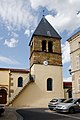
Saint-André church

Bridge over the Couze Chambron

