
Égliseneuve-d'Entraigues
| Égliseneuve-d'Entraigues | ||
|---|---|---|
.svg)
|
|
|
| region | Auvergne-Rhône-Alpes | |
| Department | Puy-de-Dôme | |
| Arrondissement | Issoire | |
| Canton | Le Sancy | |
| Community association | Agglo Pays d'Issoire | |
| Coordinates | 45 ° 25 ′ N , 2 ° 50 ′ E | |
| height | 877-1,358 m | |
| surface | 56.43 km 2 | |
| Residents | 352 (January 1, 2017) | |
| Population density | 6 inhabitants / km 2 | |
| Post Code | 63850 | |
| INSEE code | 63144 | |
| Website | http://www.egliseneuvedentraigues.fr/ | |
 View of Égliseneuve-d'Entraigues |
||

Égliseneuve-d'Entraigues is a French municipality with 352 inhabitants (at January 1, 2017) in the department of Puy-de-Dôme in the region Auvergne Rhône-Alpes (before 2016 Auvergne ). It belongs to the Arrondissement of Issoire and the canton of Le Sancy (until 2015 Besse-et-Saint-Anastaise ).
location
Égliseneuve-d'Entraigues is located about 44 kilometers south-southwest of Clermont-Ferrand on the Rhue River in Limagne . Égliseneuve-d'Entraigues is surrounded by the neighboring communities of Picherande in the north, Besse-et-Saint-Anastaise in the northeast, Compains in the east, Espinchal in the southeast, Chanterelle and Condat in the south, Montboudif in the southwest and Saint-Genès-Champespe in the west.
Population development
| year | 1962 | 1968 | 1975 | 1982 | 1990 | 1999 | 2006 | 2013 |
| Residents | 1,226 | 1,127 | 1.010 | 783 | 694 | 561 | 488 | 450 |
| Source: Cassini and INSEE | ||||||||
Attractions
- Saint-Austremoine church, originally from the 10th century, monument historique since 1969
- Notre-Dame de la Font-Sainte chapel
- water falls
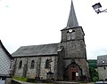
Saint-Austremoine church

Saint-Diéry Castle

Entraigues waterfall

Waterfall on the Bois de Chaux


