Auzat-la-Combelle
| Auzat-la-Combelle | ||
|---|---|---|

|
|
|
| region | Auvergne-Rhône-Alpes | |
| Department | Puy-de-Dôme | |
| Arrondissement | Issoire | |
| Canton | Brassac-les-Mines | |
| Community association | Agglo Pays d'Issoire | |
| Coordinates | 45 ° 27 ' N , 3 ° 19' E | |
| height | 389-705 m | |
| surface | 12.74 km 2 | |
| Residents | 2,076 (January 1, 2017) | |
| Population density | 163 inhabitants / km 2 | |
| Post Code | 63570 | |
| INSEE code | 63022 | |
| Website | http://www.commune-auzat-la-combelle.fr/ | |
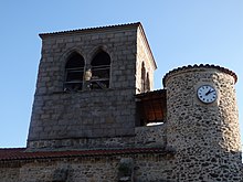
 Town hall (Mairie) of Auzat-la-Combelle |
||
Auzat-la-Combelle is a French commune in the department of Puy-de-Dôme in the region Auvergne Rhône-Alpes with 2,076 inhabitants (as of January 1 2017). The municipality belongs to the Arrondissement of Issoire and the canton of Brassac-les-Mines (until 2015: canton of Jumeaux ).
The municipality consists of the two districts of Auzat-sur-Allier and La Combelle .
geography
Auzat-la-Combelle is about 40 kilometers south-south-east of Clermont-Ferrand on the banks of the Allier , into which the Alagnon flows here. Auzat-la-Combelle is surrounded by the neighboring communities of Lamontgie in the north, Esteil in the east, Jumeaux in the south and southeast, Brassac-les-Mines in the south, Beaulieu in the west and Nonette-Orsonnette with Orsonnette in the northeast.
Population development
| 1962 | 1968 | 1975 | 1982 | 1990 | 1999 | 2006 | 2012 |
|---|---|---|---|---|---|---|---|
| 3.215 | 2,910 | 2,632 | 2,468 | 2.156 | 2,044 | 2,030 | 2,077 |
Attractions
- Saint-Géraud church
- Ruins of Cocu Castle on the Allier
- Ruins of the windmill
- Remains of the La Combelle colliery and the miners' chapel
Personalities
- Émile Clermont (1880-1916), writer
- Émile Antonio (born 1928), football player

