
Saint-Floret
| Saint-Floret | ||
|---|---|---|
.svg)
|
|
|
| region | Auvergne-Rhône-Alpes | |
| Department | Puy-de-Dôme | |
| Arrondissement | Issoire | |
| Canton | Le Sancy | |
| Community association | Agglo Pays d'Issoire | |
| Coordinates | 45 ° 33 ' N , 3 ° 6' E | |
| height | 476-929 m | |
| surface | 12.16 km 2 | |
| Residents | 251 (January 1, 2017) | |
| Population density | 21 inhabitants / km 2 | |
| Post Code | 63320 | |
| INSEE code | 63342 | |

Saint-Floret is a French municipality with 251 inhabitants (at January 1, 2017) in the department of Puy-de-Dôme in the region Auvergne Rhône-Alpes . It belongs to the Arrondissement of Issoire and the Canton of Le Sancy .
Population development
| year | 1962 | 1968 | 1975 | 1982 | 1990 | 1999 | 2007 |
| Residents | 243 | 276 | 251 | 219 | 259 | 248 | 266 |
Attractions
- Medieval bridge that spans the Couze Pavin .
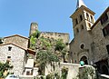
- Ruins of the fortress (13th century) with the donjon and a building with Tristan-und-Isolde - frescoes (14th century)
- Romanesque chapel (12th century) with the surrounding cemetery
Saint-Flour church
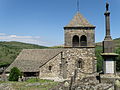
Upper Church ( Église Haute or Église du Chastel )


literature
- Charles-Laurent Salch: Dictionnaire des châteaux et des fortifications du Moyen Age en France. Éditions Publitotal, Strasbourg 1979, p. 1028 (Reprint. Ibid 1987, ISBN 2-86535-070-3 ).
Web links
Commons : Saint-Floret - Collection of images, videos and audio files