
Les Pradeaux
| Les Pradeaux | ||
|---|---|---|
|
||
| region | Auvergne-Rhône-Alpes | |
| Department | Puy-de-Dôme | |
| Arrondissement | Issoire | |
| Canton | Brassac-les-Mines | |
| Community association | Agglo Pays d'Issoire | |
| Coordinates | 45 ° 31 ' N , 3 ° 18' E | |
| height | 373-452 m | |
| surface | 5.54 km 2 | |
| Residents | 337 (January 1, 2017) | |
| Population density | 61 inhabitants / km 2 | |
| Post Code | 63500 | |
| INSEE code | 63287 | |
.JPG) Town hall (Mairie) of Les Pradeaux |
||

Les Pradeaux is a French municipality with 337 inhabitants (as of January 1 2017) in the department of Puy-de-Dôme in the region Auvergne Rhône-Alpes (before 2016 Auvergne ). It belongs to the Arrondissement of Issoire and the Canton of Brassac-les-Mines (until 2015: Canton of Sauxillanges ).
geography
Les Pradeaux is located about 31 kilometers south-southeast of Clermont-Ferrand . Les Pradeaux is surrounded by the neighboring communities of Parentignat in the north, Saint-Rémy-de-Chargnat in the east, Saint-Martin-des-Plains in the south and southeast, Nonette-Orsonnette in the south and Le Broc in the west.
Population development
| year | 1962 | 1968 | 1975 | 1982 | 1990 | 1999 | 2006 | 2013 |
| Residents | 336 | 313 | 354 | 284 | 273 | 299 | 324 | 320 |
| Source: Cassini and INSEE | ||||||||
Attractions
- Notre-Dame-de-l'Assomption church
- La Grange Fort Castle

Notre-Dame-de-l'Assomption church
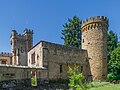
La Grange Fort Castle
.JPG)

Personalities
- Roland de La Poype (1920–2012), aviator and industrialist
Web links
Commons : Les Pradeaux - Collection of images, videos and audio files