
Lamontgie
| Lamontgie | ||
|---|---|---|
.svg)
|
|
|
| region | Auvergne-Rhône-Alpes | |
| Department | Puy-de-Dôme | |
| Arrondissement | Issoire | |
| Canton | Brassac-les-Mines | |
| Community association | Agglo Pays d'Issoire | |
| Coordinates | 45 ° 29 ′ N , 3 ° 20 ′ E | |
| height | 410-676 m | |
| surface | 7.09 km 2 | |
| Residents | 649 (January 1, 2017) | |
| Population density | 92 inhabitants / km 2 | |
| Post Code | 63570 | |
| INSEE code | 63185 | |
.JPG) Lamontgie Town Hall (Mairie) |
||

Lamontgie is a French commune in the department of Puy-de-Dôme in the region Auvergne Rhône-Alpes with 649 inhabitants (as of January 1 2017). The municipality belongs to the Arrondissement of Issoire and the canton of Brassac-les-Mines (until 2015: canton of Jumeaux ).
In addition to the core town of Lamontgie , Mailhat belongs to the municipality.
geography
Lamontgie is about 39 kilometers south-southeast of Clermont-Ferrand . Lamontgie is surrounded by the neighboring communities
- Saint-Martin-des-Plains in the north and north-west,
- Bansat in the north and northeast,
- La Chapelle-sur-Usson in the east, Esteil in the southeast,
- Auzat-la-Combelle in the south,
- Nonette-Orsonnette with Orsonnette in the west and southwest and Nonette in the west and northwest.
Population development
| 1962 | 1968 | 1975 | 1982 | 1990 | 1999 | 2006 | 2013 |
|---|---|---|---|---|---|---|---|
| 557 | 545 | 437 | 405 | 394 | 496 | 543 | 620 |
| Source: Cassini and INSEE | |||||||
Attractions
- Notre-Dame church in Mailhat, built at the end of the 12th century, monument historique
- Lamontgie Church
- Lamontgie Fortress
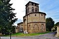
Notre-Dame Church of Mailhat

Lamontgie Church
.JPG)
.JPG)
Web links
Commons : Lamontgie - collection of images, videos and audio files